
Map data acquisition method, device and system for congested road section and storage medium

A technology of map data and collection methods, which is applied to measuring devices, road network navigators, instruments, etc., can solve problems such as missing road section data, missing image point cloud data, and affecting high-precision map production, so as to improve accuracy and efficiency. The effect of solving map data quality problems

Active Publication Date: 2020-06-26
NAVINFO
View PDF11 Cites 1 Cited by
  • Summary
  • Abstract
  • Description
  • Claims
  • Application Information

AI Technical Summary

Problems solved by technology

[0004] However, such a map data collection method is more susceptible to the influence of the external complex environment, which reduces the quality and efficiency of data collection, and affects subsequent high-precision map production.
For example: during the driving process of the mobile acquisition vehicle, it is affected by surrounding vehicles and pedestrians, resulting in the loss of image or point cloud data
In the process of making high-precision maps, it is necessary to manually draw the missing parts, and the manual workload is very large
In particular, there are some road sections that are congested for a long time during the day, and the data loss of these road sections is even more serious
When the incomplete area is large, even manual work cannot map the missing parts that meet the accuracy requirements

Method used


Image

  • Map data acquisition method, device and system for congested road section and storage medium
  • Map data acquisition method, device and system for congested road section and storage medium
  • Map data acquisition method, device and system for congested road section and storage medium

Examples


Embodiment Construction

[0033] In order to make the purpose, technical solutions and advantages of the embodiments of the present invention clearer, the technical solutions in the embodiments of the present invention will be clearly and completely described below in conjunction with the drawings in the embodiments of the present invention. Obviously, the described embodiments It is a part of embodiments of the present invention, but not all embodiments. Based on the embodiments of the present invention, all other embodiments obtained by persons of ordinary skill in the art without making creative efforts belong to the protection scope of the present invention.

[0034] The terms "first", "second", "third", "fourth", etc. (if any) in the description and claims of the present invention and the above drawings are used to distinguish similar objects, and not necessarily Used to describe a specific sequence or sequence. It is to be understood that the data so used are interchangeable under appropriate ci...


PUM


Abstract

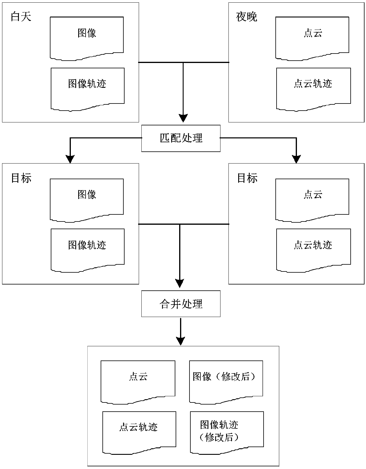
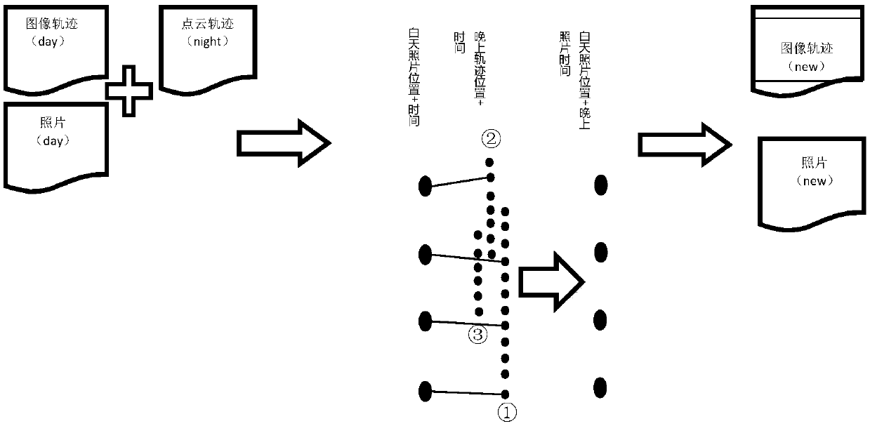
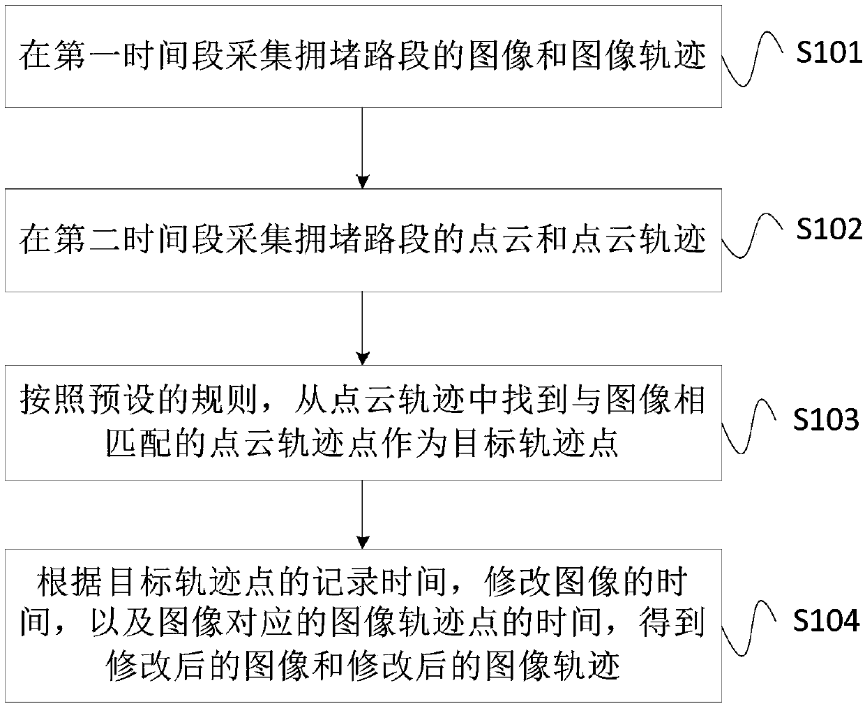
The invention provides a map data acquisition method, device and system for a congested road section and a storage medium, and the method comprises the steps: collecting an image and an image track ofthe congested road section in a first time period; collecting the point cloud and the point cloud track of the congested road section in a second time period; finding a point cloud track point matched with the image from a point cloud track as a target track point according to a preset rule; and obtaining a modified image and a modified image track according to the recording time of the target track point, the time of modifying the image and the time of the image track point corresponding to the image. Therefore, the image and the image track of the congested road section can be collected inthe first time period; the point cloud and the point cloud track of the congested road section are collected in the second time period, and the two parts of data are automatically matched and fused toobtain the map data meeting the precision requirement, so the map data quality problem caused by point cloud data shielding of the congested road section is solved, and the precision and efficiency of subsequent high-precision map making are improved.

Description

technical field [0001] The invention relates to the technical field of high-precision maps, in particular to a method, device, system and storage medium for collecting map data on congested road sections. Background technique [0002] High-precision maps are an indispensable and important supporting technology for autonomous driving, and map data collection relying on multi-sensor integrated mobile collection vehicles is the core channel for high-precision map data acquisition, and it is also one of the important links in its map production. With the increasing demand for high-precision maps, this requires map data collection to provide more accurate and fresher raw data. [0003] At present, map data collection is generally carried out by multi-sensor integrated mobile collection vehicles for field data collection. For example, if a mobile collection vehicle is equipped with various measurement devices such as laser scanners, panoramic cameras, integrated navigation (inert...

Claims


Application Information

Patent Timeline
Patent Type & Authority Applications(China)
IPC IPC(8): G01C21/34
CPCG01C21/3407
Inventor 桑萨尔周勋陈召霞张民岗王志强郭峰肖泓达时慧李训福
Owner NAVINFO
Learn More