Aircraft for unmanned underwater topographic survey

An underwater terrain and aircraft technology, which is applied to underwater ships, underwater operation equipment, special-purpose ships, etc., can solve the problems of restricting large-scale popularization and use, high cost of underwater aircraft, etc., and achieves low fluid resistance and low cost. , The effect of easy waterproof treatment

Inactive Publication Date: 2020-10-09
河南省北纬勘测设计有限公司
View PDF6 Cites 0 Cited by
  • Summary
  • Abstract
  • Description
  • Claims
  • Application Information

AI Technical Summary

Problems solved by technology

However, for underwater topographic surveys for small scientific research institutions or teaching purposes, the cost of the underwater vehicle is too high, which restricts its large-scale promotion and use.

Method used


Image

  • Aircraft for unmanned underwater topographic survey
  • Aircraft for unmanned underwater topographic survey
  • Aircraft for unmanned underwater topographic survey

Examples


Embodiment Construction

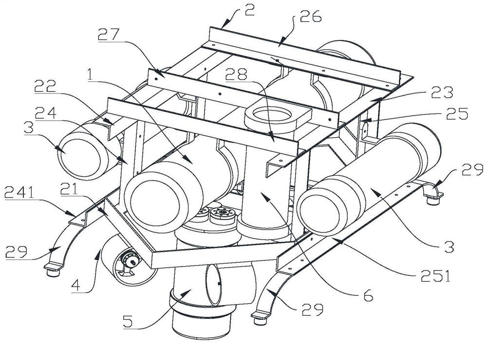
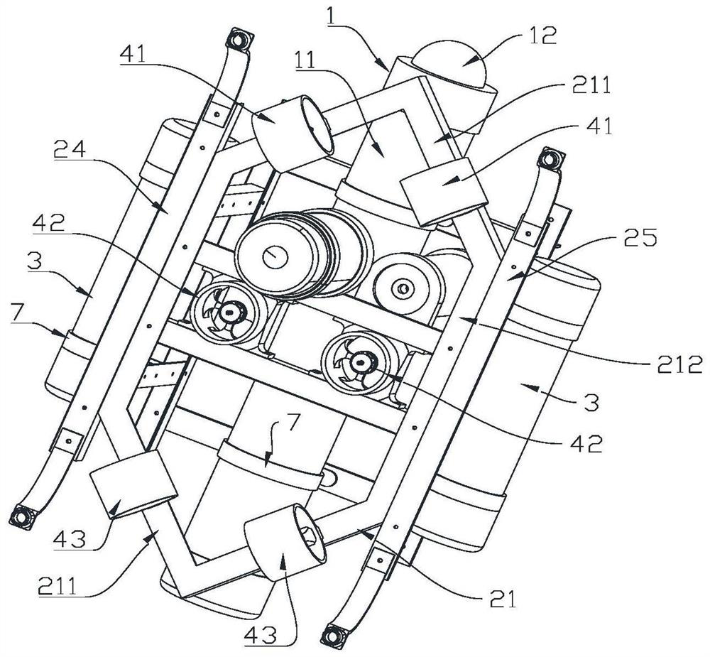
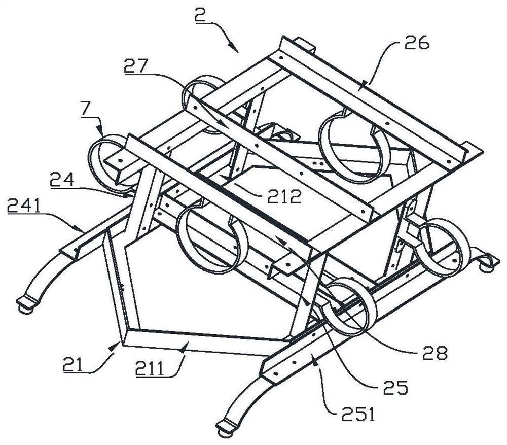
[0033] In order to make the objectives, technical solutions, and advantages of the embodiments of the present disclosure clearer, the technical solutions of the embodiments of the present disclosure will be described clearly and completely in conjunction with the accompanying drawings of the embodiments of the present disclosure.

[0034] Obviously, the described embodiments are part of the embodiments of the present disclosure, rather than all of the embodiments. Based on the described embodiments of the present disclosure, all other embodiments obtained by those of ordinary skill in the art without creative labor are within the protection scope of the present disclosure.

[0035] Unless otherwise defined, the technical terms or scientific terms used in the present disclosure shall have the usual meanings understood by those with ordinary skills in the field to which this disclosure belongs. The words "include" or "include" and other similar words used in the present disclosure me...


PUM


Abstract

The invention discloses an aircraft for unmanned underwater topographic survey. The aircraft comprises a control part which comprises a closed cylindrical body, and a control panel and a power supplyassembly which are arranged in the cylindrical body, and a frame body which is a frame body formed by a plurality of sections of section bars; the frame body comprises a bottom frame and a first sideframe and a second side frame which are arranged on the two opposite sides of the bottom frame; a first top boundary beam is arranged at the top of the first side frame, a second top boundary beam isarranged at the top of the second side frame, the first top boundary beam and the second top boundary beam are parallel to each other, and a first cross beam, a second cross beam and a third cross beam are sequentially arranged between the first top boundary beam and the second top boundary beam; the cylindrical body is connected with the frame body through fixing pieces arranged on the first cross beam and the third cross beam respectively; the aircraft further comprises a buoy, a sonar assembly and a video acquisition assembly. The aircraft for unmanned underwater topographic survey providedby the invention is made of common sectional materials, has relatively small fluid resistance and is low in manufacturing cost.

Description

Technical field [0001] The invention relates to an underwater measuring equipment, in particular to an unmanned aerial vehicle for underwater topographic surveying. Background technique [0002] Underwater topographic survey is a specific survey in engineering surveying. It measures the plane position and elevation of rivers, lakes, reservoirs, harbors, and offshore bottom points to draw underwater topographic maps. One of the important content is water depth measurement. Water depth measurement generally uses sounding rods, sounding hammers, and sonar echo sounders. The bottom elevation is calculated based on the results of water depth measurement and water level observation. Finally, contour lines (or contour lines) are used to indicate the topography of the bottom . For water depth measurement, sonar echo sounders are now commonly used. They have the advantages of high accuracy and efficiency. The maximum sounding depth can reach 10000m. It has developed from single frequenc...

Claims


Application Information

Patent Timeline
Patent Type & Authority Applications(China)
IPC IPC(8): B63C11/52B63G8/00B63G8/38B63G8/39
CPCB63C11/52B63G8/00B63G8/38B63G8/39B63G2008/002
Inventor 李伟刘孔喜齐跃基王凯高大鹏王杰张粉霞张男赵佳佳雒利利
Owner 河南省北纬勘测设计有限公司
Why Eureka
Try Eureka