Road sign intelligent identification aided fusion navigation positioning method and device

A technology that integrates navigation and intelligent identification, applied in the field of navigation and positioning, can solve problems such as the inability to obtain high-precision positioning, achieve high-precision positioning, eliminate navigation and positioning errors, and achieve the effects of easy identification

Pending Publication Date: 2020-10-13
江苏集萃移动通信技术研究所有限公司
View PDF1 Cites 1 Cited by
  • Summary
  • Abstract
  • Description
  • Claims
  • Application Information

AI Technical Summary

Problems solved by technology

[0008] Purpose of the invention: In view of the defect that high-precision positioning cannot be obtained when the satellite navigation system is unavailable in the prior art, the present invention discloses a fusion navigation positioning method and device assisted by intelligent identification of road signs. Integrate into navigation to achieve high-precision positioning in various scenarios

Method used


Image

  • Road sign intelligent identification aided fusion navigation positioning method and device
  • Road sign intelligent identification aided fusion navigation positioning method and device
  • Road sign intelligent identification aided fusion navigation positioning method and device

Examples


Embodiment Construction

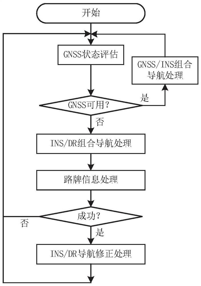
[0051] Below in conjunction with accompanying drawing, this scheme is described and explained further.

[0052] There are a large number of various signs and signs placed in and around urban roads. For example, road traffic signs use text or graphic symbols to convey instructions, prohibitions and other signals to vehicles and pedestrians, or indicate road directions, road names, etc. For another example, there are some signs used for publicity, advertisement, etc. in places near the road. Some of these signs provide information that can be used for orientation. Such signs have the following characteristics:

[0053] 1) The contents of these signs are easy to identify. For example, traffic signs are usually white on a blue background. The content of the signs is mainly text, without complicated patterns, which is easy for computers to recognize.

[0054] 2) These signs are unique within a small area. First of all, road names in a region are generally unique; secondly, ev...


PUM


Abstract

The invention discloses a road sign intelligent identification aided fusion navigation positioning method and device. The method is applied to the technical field of navigation positioning. The methodcomprises the following steps: firstly, evaluating the state of the GNSS; carrying out GNSS / INS integrated navigation under the condition that the GNSS state is good, otherwise carrying out INS / DR integrated navigation, and achieving high-precision navigation positioning through road sign information processing and road sign information auxiliary navigation correction in the INS / DR integrated navigation process. According to the invention, most road signs have the characteristics of uniqueness, easy identification, accurate position information, easy acquisition and the like; in a scene withinsufficient availability of a satellite navigation system, accurate position information provided by a road sign is used for providing position correction for an INS / DR integrated navigation system,and high-precision positioning in a GNSS unavailable scene is achieved.

Description

technical field [0001] The invention relates to the technical field of navigation and positioning, in particular to a fusion navigation and positioning method and device aided by intelligent identification of road signs. Background technique [0002] High-precision positioning has important applications in many fields. For example, with the rapid development of autonomous driving technology, navigation systems need to meet higher requirements, including: high precision, high resolution, high reliability, low cost, low power consumption, and miniaturization. However, none of the current major navigation and positioning technologies can meet these requirements alone. [0003] The Global Navigation Satellite System (GNSS) is currently the main positioning technology, which has the advantages of global coverage, all-weather operation, and high positioning accuracy, and has become the most extensive means of positioning and navigation. However, in some cases GNSS availability i...

Claims


Application Information

Patent Timeline
IPC IPC(8): G01S19/49G01C21/16G01C25/00G01C22/00
CPCG01C21/165G01C22/00G01C25/005G01S19/49
Inventor 刘立刚卜智勇周斌金圣峣
Owner 江苏集萃移动通信技术研究所有限公司
Why Eureka
Try Eureka