
Center line calibration method for underground linear roadway

A calibration method and centerline technology, which is applied to measurement devices, instruments, surveying and mapping, and navigation, etc., can solve the problems of complicated measurement procedures and low work efficiency, and achieve the effect of saving measurement procedures, improving work efficiency, and saving time for calculating data.

Pending Publication Date: 2021-03-26
CHINA HUAYE GROUP
View PDF5 Cites 0 Cited by
  • Summary
  • Abstract
  • Description
  • Claims
  • Application Information

AI Technical Summary

Problems solved by technology

[0003] In view of the above-mentioned problems, the purpose of the present invention is to provide a method for marking the center line of an underground straight roadway, so as to solve the problem that in the prior art, at least two stations need to be set up in the process of marking the center line of a long-distance straight roadway. Complicated procedures and low work efficiency

Method used


Image

  • Center line calibration method for underground linear roadway
  • Center line calibration method for underground linear roadway

Examples


Embodiment Construction

[0025] In the following description, for purposes of explanation, numerous specific details are set forth in order to provide a thorough understanding of one or more embodiments. It may be evident, however, that these embodiments may be practiced without these specific details.

[0026] Aiming at the problems mentioned above, in the current prior art, in the process of center line calibration for long-distance straight roadways, at least two stations need to be set up, the measurement process is complicated, and the work efficiency is low. A center line calibration of underground straight roadways is proposed. method.

[0027] Specific embodiments of the present invention will be described in detail below in conjunction with the accompanying drawings.

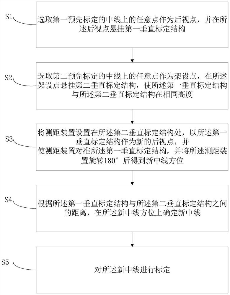
[0028] In order to illustrate the centerline calibration method of the underground straight roadway provided by the present invention, figure 1 The flow chart of the centerline calibration method of the underground straight r...


PUM


Abstract

The invention provides a center line calibration method for an underground straight roadway, which comprises the following steps of: selecting any point on a first pre-calibrated center line as a rearview point, and suspending a first vertical calibration structure at the rear view point; selecting any point on a second pre-calibrated center line as an erection point, and suspending a second vertical calibration structure at the erection point; arranging a distance measuring device at the second vertical calibration structure, taking the first vertical calibration structure as a new rear viewpoint, enabling the distance measuring device to be aligned with the first vertical calibration structure, and rotating the distance measuring device by 180 degrees to obtain a new central line orientation; determining a new center line in the direction of the new center line according to the distance between the first vertical calibration structure and the second vertical calibration structure;and calibrating the new center line. The invention can solve the problems that at least two station instruments need to be erected, the measurement process is complicated, the working efficiency is low and the like in the process of carrying out center line calibration on a long-distance linear roadway in the prior art.

Description

technical field [0001] The invention belongs to the technical field of downhole ranging, and more specifically relates to a method for marking the centerline of downhole straight roadways. Background technique [0002] At present, the downhole center line stakeout is usually a group of 30m to 40m, and the points on the center line to be placed are derived from known control points, and then the center line is determined after setting up instruments on the center line points. This method requires at least two stations of instruments. The whole midline calibration process is relatively complicated. If the above-mentioned method is used for long-distance straight roadways, such as the quasi-slope of the piercing roadway of the quasi-acquisition project, it will take a lot of time, the measurement process is complicated, and the work efficiency is low. Contents of the invention [0003] In view of the above problems, the purpose of the present invention is to provide a method ...

Claims


Application Information

Patent Timeline
Patent Type & Authority Applications(China)
IPC IPC(8): G01C15/00
CPCG01C15/00
Inventor 王健段超林张生良鞠占永刘洋黄晓东吴子晓
Owner CHINA HUAYE GROUP
Learn More