Three-dimensional air route planning method, system and device and medium

A route, three-dimensional technology, applied in image data processing, special data processing applications, 3D modeling, etc., can solve the problem of inability to take into account the height information, and achieve the effect of convenient and fast modification and adjustment, easy to distinguish, and easy to display.

Active Publication Date: 2021-04-23
上海狮尾智能化科技有限公司
View PDF10 Cites 2 Cited by
  • Summary
  • Abstract
  • Description
  • Claims
  • Application Information

AI Technical Summary

Problems solved by technology

[0005] Aiming at the problem that altitude information cannot be taken into account in the route planning process in the prior

Method used


Image

  • Three-dimensional air route planning method, system and device and medium
  • Three-dimensional air route planning method, system and device and medium
  • Three-dimensional air route planning method, system and device and medium

Examples


Embodiment 1

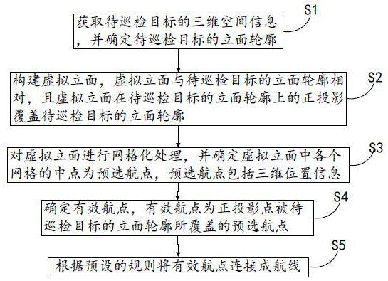
[0064] A three-dimensional route planning method, such as figure 1 As shown, it includes step S1, step S2, step S3, step S4 and step S5.

[0065] Step S1, obtaining the three-dimensional space information of the target to be inspected, and determining the elevation profile of the target to be inspected;

[0066] In this embodiment, the three-dimensional space information of the object to be inspected is obtained through the three-dimensional map, and the outline boundary line of the object to be inspected is obtained through the top view, and then the height information of the object to be inspected is obtained, so that the boundary line of the outline and the height of the object to be inspected are obtained. The information can determine the facade contour of the target to be inspected. For example, for a building, the facade contour of the target to be inspected is the side of the building, and any point on the facade contour of the target to be inspected contains Longitud...

Embodiment 2

[0103] A three-dimensional route planning method, such as Figure 10 shown, including the following steps:

[0104] Step S21, obtaining the three-dimensional space information of the target to be patrolled, and determining the outer envelope surface of the target to be patrolled;

[0105] Wherein, the outer envelope surface refers to the outer surface of the target to be inspected, and preferably refers to the circumferential outer surface in the horizontal direction.

[0106] Step S22, constructing a virtual base surface, which is obtained by equidistantly amplifying the outer envelope surface of the target to be inspected;

[0107] That is, the virtual base surface is the same as the outer envelope surface in shape, and can be regarded as the enlarged outer envelope surface of the target to be inspected. There is a certain distance between the virtual base surface and the outer envelope surface of the object to be inspected. The virtual base surface surrounds the target to...

Embodiment 3

[0114] The present invention also provides a three-dimensional route planning system, such as Figure 11 shown, including

[0115] An acquisition module, the acquisition module is used to acquire the three-dimensional space information of the target to be patrolled, and determine the facade profile of the target to be patrolled;

[0116] building blocks, the building blocks are used to build virtual facades and virtual bases;

[0117] A processing module, the processing module is used to perform grid processing on the virtual facade and obtain pre-selected waypoints, and to perform segmentation processing on the virtual base surface and obtain a track layer;

[0118] A determination module, the determination module is used to determine a valid waypoint from the pre-selected waypoints, and is used to determine an exit waypoint on the track layer;

[0119] And a planning module, the planning module is used to connect the effective waypoints in the virtual facade into a route, ...


PUM


Abstract

The invention discloses a three-dimensional air route planning method, system device and a medium, and belongs to the field of route planning, and the method comprises the steps of obtaining the three-dimensional space information of a to-be-inspected target, and determining the vertical face contour of the to-be-inspected target; constructing a virtual facade which is opposite to the facade contour of the to-be-inspected target, wherein the orthographic projection of the virtual facade on the facade contour of the to-be-inspected target covers the facade contour of the to-be-inspected target; gridding the virtual facade, and determining the midpoint of each grid in the virtual facade as a pre-selected waypoint; determining a pre-selected waypoint, covered by the vertical surface contour of the to-be-inspected target, of the projection point as an effective waypoint; and connecting the effective waypoints into a route according to a preset rule. According to the invention, accurate facade route planning is facilitated, observation is also facilitated, and the route planning efficiency can be effectively improved.

Description

technical field [0001] The invention relates to the field of route planning, in particular to a three-dimensional route planning method, system, equipment and medium. Background technique [0002] Route design refers to the method of planning the flight trajectory of the aircraft. With the increasing maturity of UAV software and hardware technology, its application scope is becoming more and more extensive. Route design is a particularly important link in the application field of industrial UAVs. Through route design, UAVs can complete intelligent inspection operations according to specified route tasks. [0003] At present, the task applied to UAV route design is implemented on a two-dimensional map. Click a specific location on the map to get a waypoint containing longitude and latitude values, but there is no altitude information for the waypoint, which requires manual input. Accurate height information needs to be obtained from other channels, otherwise, a height value ...

Claims


Application Information

Patent Timeline
IPC IPC(8): G06F30/18G06T17/20G06T7/64G06T7/11
CPCG06F30/18G06T17/20G06T7/64G06T7/11
Inventor 不公告发明人
Owner 上海狮尾智能化科技有限公司
Why Eureka
Try Eureka