Remote sensing identification method for abandoned land

A technology for remote sensing identification and wasteland, which is applied in the field of remote sensing imagery and agricultural remote sensing. It can solve problems such as the difficulty of dynamic changes, the instability of cultivated land abandonment, and the scattered spatial distribution. Effect

Pending Publication Date: 2021-05-04
北京星衡科技有限公司
View PDF0 Cites 1 Cited by
  • Summary
  • Abstract
  • Description
  • Claims
  • Application Information

AI Technical Summary

Problems solved by technology

Due to the gradual change, instability, and scattered spatial distribution of cultivated land abandonment, it is difficult to confirm its information and grasp the dynamic changes of abandoned land

Method used


Image

  • Remote sensing identification method for abandoned land
  • Remote sensing identification method for abandoned land

Examples


Embodiment Construction

[0053] The present invention will be described in further detail below in conjunction with the accompanying drawings.

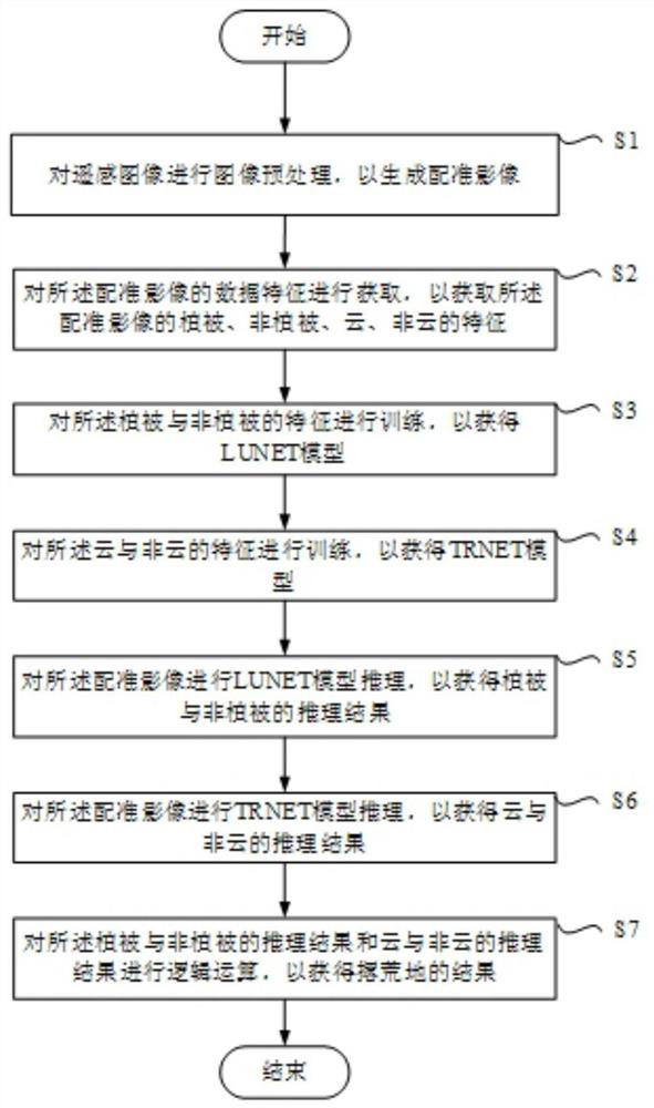
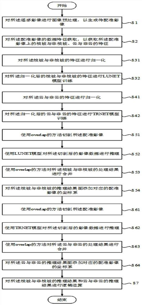
[0054] See figure 1 , a flowchart of a remote sensing identification method for abandoned land in the present invention. In step S1, image preprocessing is performed on the remote sensing image to generate a registration image; in step S2, the data characteristics of the registration image are acquired to obtain the vegetation, non-vegetation, and cloud on the registration image. and non-cloud features; in step S3, the vegetation and non-vegetation features are trained to obtain a LUNET model; in step S4, the cloud and non-cloud features are trained to obtain a TRNET model; In step S5, LUNET model inference is performed on the registered image to obtain the inference result of vegetation and non-vegetation; in step S6, TRNET model inference is performed on the registered image to obtain the inference result of cloud and non-cloud Result; in step S7, logical...


PUM


Abstract

The invention provides a remote sensing recognition method for an abandoned land, and the method achieves the extraction of the abandoned land from a remote sensing image through the steps of image preprocessing, feature extraction, model training, reasoning, logic operation and the like. By means of the abandoned land extraction method, the accuracy of the extracted abandoned land can be greatly improved, the efficiency is greatly superior to that of a manual mode, and the problem that manpower is consumed in abandoned land extraction is solved. In addition, the LUNT model is superior to the UNET model, the good integrality of the model classification result can be guaranteed, and meanwhile, the number of plaques is small. Meanwhile, the generalization of the TRNET model is better than that of the UNET model, and the abandoned land extraction accuracy can be improved under the condition that the characteristic quantity is not increased.

Description

technical field [0001] The invention relates to the technical field of remote sensing images, in particular to a technology for identifying abandoned land in the field of agricultural remote sensing. Background technique [0002] Remote Sensing Image (Remote Sensing Image) refers to the film or photo that records the electromagnetic wave size of various ground features, such as aerial photos and satellite photos. Each remote sensing image contains corresponding geographic coordinates. In other words, each pixel in a remote sensing image can obtain its unique geographic coordinate position. [0003] So far, the research on cultivated land abandonment in my country mainly relies on the collection of statistical data and household survey data for comparative analysis. Due to the gradual change, instability, and scattered spatial distribution of cultivated land abandonment, it is difficult to confirm its information and grasp the dynamic changes of abandoned land. Due to the c...

Claims


Application Information

Patent Timeline
Patent Type & Authority Applications(China)
IPC IPC(8): G06K9/00G06K9/62G06T7/33G06N3/04G06N3/08
CPCG06T7/33G06N3/08G06T2207/10032G06T2207/20081G06T2207/20084G06T2207/30188G06V20/188G06N3/044G06N3/045G06F18/22G06F18/253G06F18/24
Inventor 王建凤黄先梅郎彦
Owner 北京星衡科技有限公司
Why Eureka
Try Eureka