Pavement settlement monitoring system and method based on gnss and inclination sensors

A technology of inclination sensor and settlement monitoring, applied in the direction of instruments, measuring devices, surveying and navigation, etc., can solve the problems of dangerous situation prediction, large error and high measurement cost

Active Publication Date: 2022-03-22
武汉智菱物联科技有限公司
View PDF8 Cites 0 Cited by
  • Summary
  • Abstract
  • Description
  • Claims
  • Application Information

AI Technical Summary

Problems solved by technology

[0002] The measurement of road surface settlement in existing projects is mainly based on total stations and leveling instruments. Such instruments must be operated by manual observation. Basically, it is impossible to realize fully automatic measurement and data transmission, and the errors are relatively large.
The operator is required to operate at the measurement point during the measurement, but generally the measurement points are located on the road with heavy traffic or on a relatively dangerous roadbed, which has no strong guarantee for the safety of the operator, and the measurement cost of each point is thousands of yuan For this reason, various departments have to spend considerable manpower and material resources
[0003] The Chinese patent with publication number CN111926662A disclosed an online monitoring method of road surface settlement on November 13, 2020. By setting the monitoring standard template at the road surface monitoring point, the template standard line is set on the monitoring standard template; Template standard line; align the laser emitting device vertically with the plane where the monitoring standard template is located to obtain the spot; determine the distance between the spot and the standard line of the template, set it as the first distance; after setting the time length, determine the distance between the spot and the standard line of the template The distance between is set as the second distance; if the first distance and the second distance are the same, no road surface settlement occurs; if the first distance and the second distance are different, road surface settlement occurs; obtain the laser emission angle of the inclination measurement module; According to the first distance, the second distance and the laser emission angle, the road surface settlement value of the road surface monitoring point is determined, which solves the problem that the safety of the surveyor cannot be guaranteed, the measurement cost is high, and the road surface settlement data cannot be monitored online in real time in the existing measurement method
The defects in this patent application are: 1) The monitoring point must be equipped with a monitoring standard template and a laser emitting device vertically aligned with the standard template. The error of the standard module, the laser emitting device itself and the error in the vertical alignment process will affect the monitoring accuracy. Cause false alarms; 2) only monitor designated points on the road surface, not suitable for road subsidence monitoring within a long road section, lack of comprehensive consideration of the change trend of road surface subsidence in a long road section; 3) only achieve monitoring, but not Anticipate dangerous situations
However, this patent application lacks a comprehensive consideration of the trend of road surface settlement changes in longer road sections, and does not predict dangerous situations

Method used


Image

  • Pavement settlement monitoring system and method based on gnss and inclination sensors
  • Pavement settlement monitoring system and method based on gnss and inclination sensors

Examples


Embodiment approach

[0055] As an implementation manner, the method further includes judging abnormal inclination:

[0056] Calculate the first-order derivative of the angle data obtained by each inclination sensor, and calculate the rate of inclination change at each monitoring point;

[0057] The rate of inclination change calculated by each monitoring point is compared with the preset rate of change of inclination. If the rate of change of inclination exceeds the preset rate of change of inclination, the corresponding monitoring point is determined as an abnormal area of ​​inclination, and a second alarm message is output.

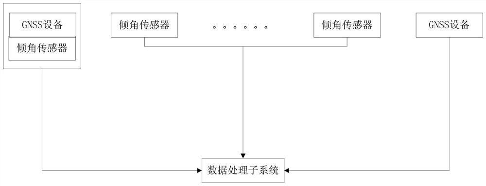
[0058] As an implementation manner, the method further includes: setting the location of the first GNSS device as the first monitoring point, corresponding to the first inclination sensor, and calculating the second inclination sensor using the angle data of the first inclination sensor. The settlement height of the monitoring point, and so on, until the settlement height o...


PUM


Abstract

The invention discloses a road surface settlement monitoring system and method based on GNSS and an inclination sensor. The GNSS equipment at both ends of the monitoring road section obtains the road surface settlement height at the starting point and the end point of the monitoring road section, and the inclination angle of each monitoring point between the two ends is obtained through the inclination sensor. Change, and calculate the road surface settlement height based on the change of inclination angle, compare the road surface settlement height obtained by using GNSS equipment with the calculated road surface settlement height, and when the comparison result does not exceed the threshold value, the iterative error in the calculation is compensated. When the result exceeds the threshold, the settlement alarm area is determined and the alarm information is output; the present invention realizes the real-time monitoring of road surface settlement, and realizes the road curvature by monitoring the road surface settlement data obtained at both ends of the road section and the road surface settlement data obtained based on the change of inclination data. The real restoration makes the road subsidence data of the monitored road section closer to the real road conditions, and provides more accurate data support and risk prediction for road subsidence monitoring.

Description

technical field [0001] The invention relates to the technical field of road surface settlement monitoring, in particular to a road surface settlement monitoring system and method based on GNSS and an inclination sensor. Background technique [0002] The measurement of road surface settlement in existing projects is mainly based on total stations and levels. Such instruments must be operated by manual observation. Basically, it is impossible to realize fully automatic measurement and data transmission, and the errors are relatively large. The operator is required to operate at the measurement point during the measurement, but generally the measurement points are located on the road with heavy traffic or on a relatively dangerous roadbed, which has no strong guarantee for the safety of the operator, and the measurement cost of each point is thousands of yuan Above, each department also has to expend considerable manpower and material resources for this reason. [0003] The Ch...

Claims


Application Information

Patent Timeline
Patent Type & Authority Patents(China)
IPC IPC(8): G01C5/00
CPCG01C5/00
Inventor 黄辉雷俊伍齐林冯喜明叶宏董中蒋清河漆伟朱鹏峰王顺虎鄢子淳费良琴江紫莹李洲
Owner 武汉智菱物联科技有限公司
Why Eureka
Try Eureka