Eureka AIR delivers breakthrough ideas for toughest innovation challenges, trusted by R&D personnel around the world.

GNSS enhancement system suitable for tunnel environment

A technology for enhancing system and tunnel environment, applied in the field of satellite navigation, it can solve the problems of difficult reception of navigation signals, restrictive layout conditions, immaturity, etc., to achieve high-precision indoor timing and improve real-time performance.

Pending Publication Date: 2022-05-10
杭州北斗时空研究院
View PDF0 Cites 0 Cited by
  • Summary
  • Abstract
  • Description
  • Claims
  • Application Information

AI Technical Summary

Problems solved by technology

[0002] With the improvement of people's living standards, people put forward higher requirements for information services. In the field of location services, the GNSS navigation system can usually meet the high-precision positioning and location-based application services outdoors of the crowd. However, due to the GNSS system diagram In the case of shadowing in the space area, it is generally difficult to receive navigation signals, especially in indoor spaces and tunnel spaces. In the past two years, people have put forward higher requirements for the continuity of real-time positioning between tunnels and outdoors. Realize continuous outdoor and tunnel positioning without changing the positioning terminal
There are two existing tunnel positioning technologies, one is radar ultrasonic positioning, which has poor positioning accuracy and has restrictive layout conditions; the other is positioning based on vision and inertial assistance, when there is no characteristic information in the tunnel, Error accumulation will increase rapidly, resulting in invalid positioning
Both methods are currently immature and are still under further study

Method used


Image

  • GNSS enhancement system suitable for tunnel environment
  • GNSS enhancement system suitable for tunnel environment
  • GNSS enhancement system suitable for tunnel environment

Examples


Embodiment Construction

[0022] In order to make the purpose, technical solutions and advantages of the embodiments of the present invention clearer, the technical solutions in the embodiments of the present invention will be clearly and completely described below. Apparently, the described embodiments are some, but not all, embodiments of the present invention. Based on the embodiments of the present invention, all other embodiments obtained by persons of ordinary skill in the art without creative efforts fall within the protection scope of the present invention.

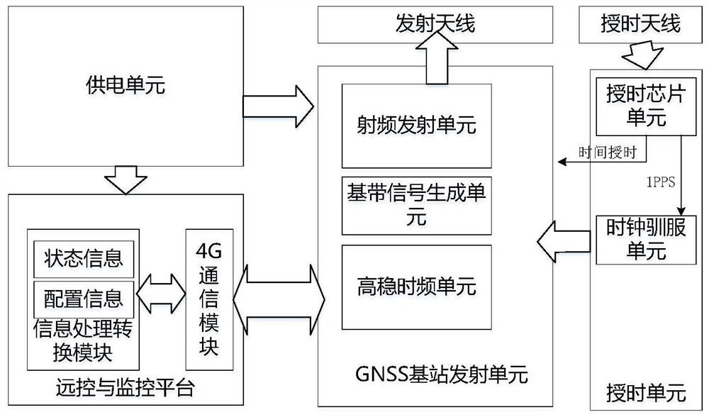
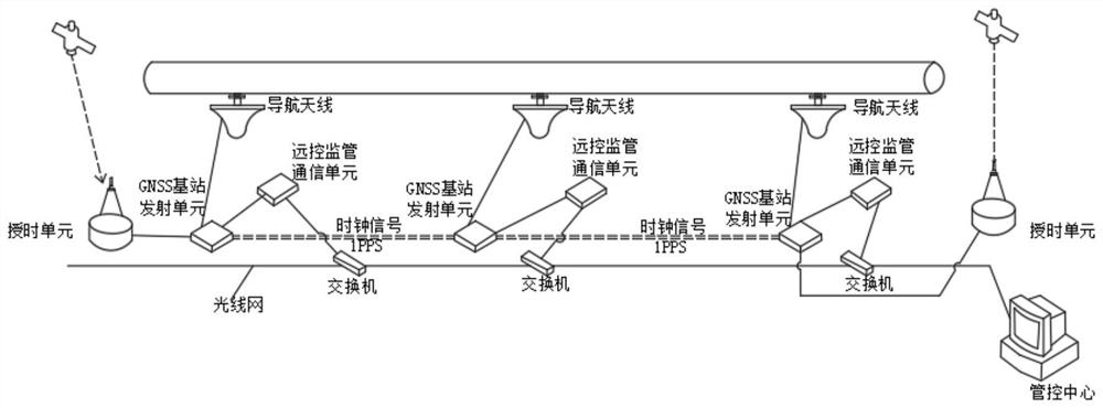
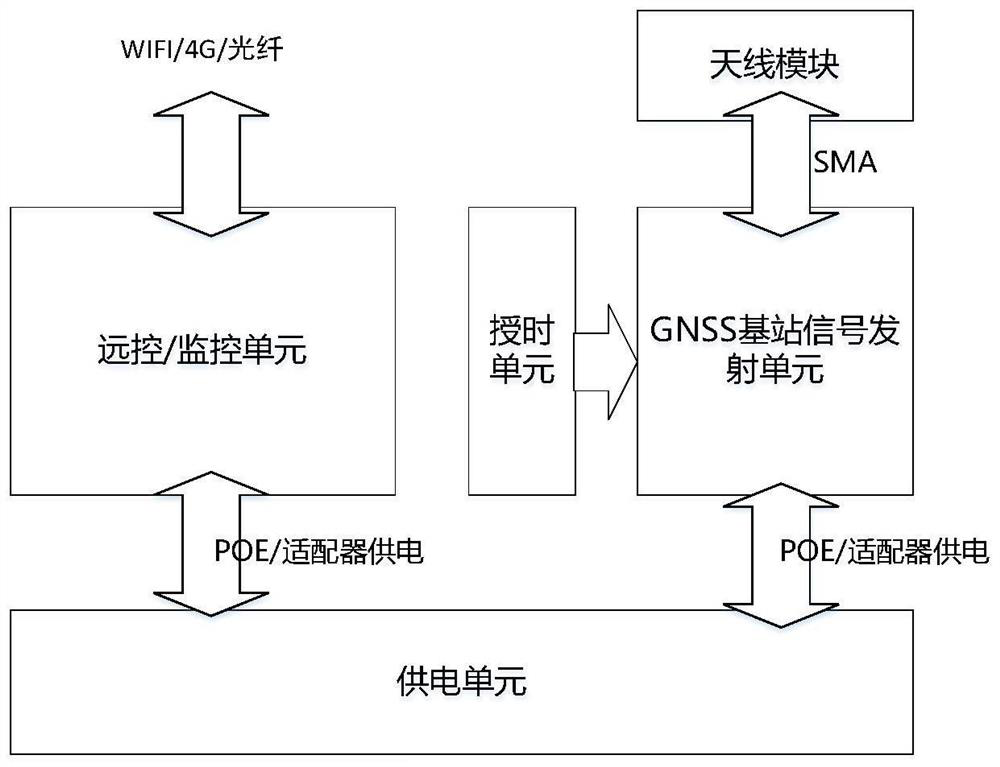
[0023] refer to Figure 1-3 , the present invention will be further described in conjunction with embodiment.

[0024] A GNSS augmentation system suitable for tunnel environments, comprising a timing unit, a GNSS base station transmitting unit, a remote control and monitoring platform, a control center, a timing antenna, a transmitting antenna and a power supply unit;

[0025] The GNSS base station transmitting unit is responsible for ge...


PUM


Abstract

The invention relates to the technical field of satellite navigation, in particular to a GNSS (Global Navigation Satellite System) enhancement system suitable for a tunnel environment, which comprises a time service unit, a GNSS base station transmitting unit, a remote control and supervision platform, a management and control center, a time service antenna, a transmitting antenna and a power supply unit, the navigation signal is radiated to a tunnel space through a navigation signal transmitting antenna; the remote control and monitoring platform mainly completes three aspects of contents: on one hand, remote parameter configuration of each transmitting platform of a subsystem is realized; continuous positioning inside and outside the tunnel is achieved under the condition that navigation signals are not changed, time synchronization control between base stations of a system in the tunnel is effectively achieved, the real-time performance of system supervision and signal parameters is effectively improved, the navigation positioning function of the environment in the tunnel is achieved, high-precision indoor time service is further provided, and the service life of the system is prolonged. And new positioning feasibility is provided for the environment in the tunnel.

Description

technical field [0001] The invention relates to the technical field of satellite navigation, in particular to a GNSS augmentation system suitable for tunnel environments. Background technique [0002] With the improvement of people's living standards, people put forward higher requirements for information services. In the field of location services, the GNSS navigation system can usually meet the high-precision positioning and location-based application services outdoors of the crowd. However, due to the GNSS system diagram In the case of shadowing in the space area, it is generally difficult to receive navigation signals, especially in indoor spaces and tunnel spaces. In the past two years, people have put forward higher requirements for the continuity of real-time positioning between tunnels and outdoors. Continuous outdoor and tunnel positioning can be realized without changing the positioning terminal. There are two existing tunnel positioning technologies, one is radar...

Claims


Application Information

Patent Timeline
Patent Type & Authority Applications(China)
IPC IPC(8): G01S19/03G01S19/12G01S19/14
CPCG01S19/03G01S19/12G01S19/14
Inventor 车洪峰周天乐王艳艳曹亚光
Owner 杭州北斗时空研究院
Why Eureka
Eureka Blog
Learn More