
GPS device and method for displaying raster images

a raster image and gps technology, applied in wave based measurement systems, navigation instruments, instruments, etc., can solve the problems of unprotected paper maps and photographs notoriously difficult to maintain, no stand-alone gps device allows for displaying aerial photographs or other geo-referenced raster images, and achieves easy and quick viewing. , the effect of eliminating disorientation

Inactive Publication Date: 2006-07-20
BUSHNELL
View PDF6 Cites 91 Cited by
  • Summary
  • Abstract
  • Description
  • Claims
  • Application Information

AI Technical Summary

Benefits of technology

[0010] The present invention also allows for toggling between different images while the aforementioned geo-referenced information remains continuously displayed so that the user can easily and quickly view or otherwise investigate prior paths, future paths, waypoints, and other geo-referenced information from a variety of different perspectives without experiencing disorientation.
[0011] The GPS device may include any or all of various obtainment mechanisms, such as an input port, a transceiver, and / or a plurality of exchangeable memory devices, for obtaining desired raster images for display. The input port allows for prior downloading and storing of the raster images from a remote source via a network. The transceiver allows for prior or current downloading and storing of the desired images via a wireless network prior to entering or while in the field. The exchangeable memory devices allow for selecting and carrying a larger number of raster images than would otherwise be possible using only the GPS device's limited onboard memory. More specifically, a large number of raster images can be downloaded and stored on a plurality of the exchangeable memory devices prior to entering the field, and, when a particular stored raster image is desired, the particular memory device on which it is stored can be inserted into the GPS device.
[0012] Thus, it will be appreciated that the GPS device and method of the present invention provides a number of substantial advantages over the prior art, including, for example, allowing for displaying any of a variety of different types of geo-referenced raster images on a small, lightweight, and rugged GPS device, and for integrating said images into a scheme of information which is relevant to navigation and travel generally.
[0013] Furthermore, the present invention advantageously allows for displaying geo-referenced information over or otherwise in association with a displayed raster image, and for continuously displaying said information while toggling between maps, photographs, to other images or views, thereby eliminating disorientation and more fully and usefully integrating the raster image into the information scheme.

Problems solved by technology

Because these enthusiasts often travel on foot or in or on light vehicles, the space requirements for and weight of all such items are important considerations that limit the number and variety of maps and photographs that can be carried into the field.
Furthermore, unprotected paper maps and photographs are notorious difficult to maintain, particularly under adverse weather conditions.
Unfortunately, no stand-alone GPS device allows for displaying aerial photographs or other geo-referenced raster images.
It is possible to download and display such images on computers and personal digital assistants that are coupled or otherwise provided with a GPS module, but these combination devices are too large, heavy, expensive, or fragile for use in the field, particularly under adverse weather conditions.
In fact, the use of computers and PDAs raises many of the same problems and limitations as the aforementioned paper maps and photographs.
While some brands of computers and PDAs offer supplemental enclosures for outdoor use, these enclosures significantly increase the already substantial size, weight, and expense of those devices.
Furthermore, the connection between the computer or PDA and the GPS module requires a USB, Bluetooth, or other connection which further adds to the ungainliness, fragility, and general undesirability of this solution

Method used


Image

  • GPS device and method for displaying raster images
  • GPS device and method for displaying raster images
  • GPS device and method for displaying raster images

Examples


Embodiment Construction

, below.

BRIEF DESCRIPTION OF THE DRAWINGS

[0015] A preferred embodiment of the present invention is described in detail below with reference to the attached drawing figures, wherein:

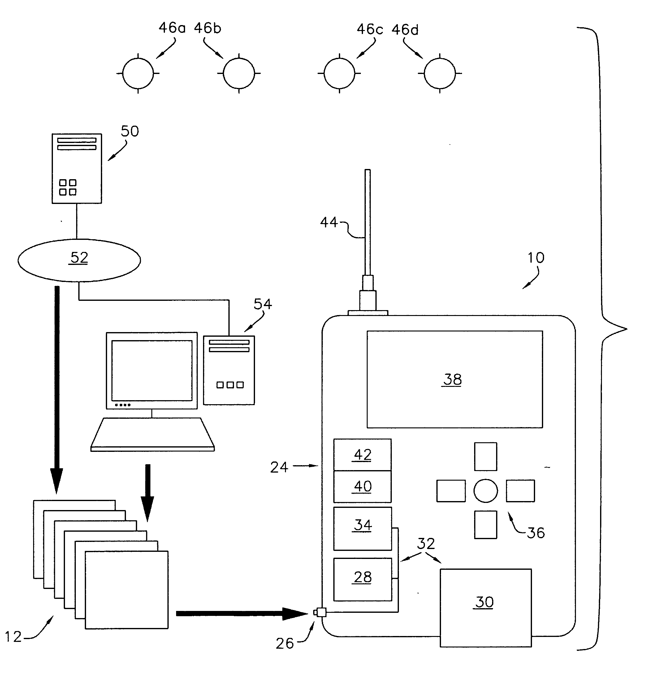
[0016]FIG. 1 is a block-diagram depiction of a preferred embodiment of a GPS device and system of the present invention;

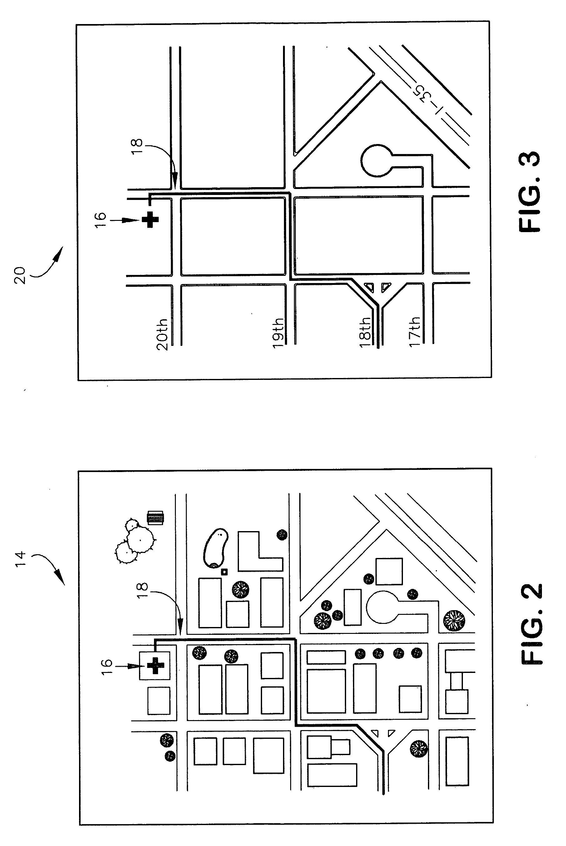
[0017]FIG. 2 is a depiction of a first geo-referenced aerial photograph overlayed with a waypoint and a trail, wherein the geo-referenced aerial photograph is displayed on a display component of the GPS device of FIG. 1;

[0018]FIG. 3 is a depiction of geo-referenced street map overlayed with the waypoint and the trail of FIG. 2, wherein the geo-referenced street map is displayed on the display component of the GPS device of FIG. 1, and wherein a user of the GPS device can toggle between the aerial photograph of FIG. 2 and the street map of FIG. 3 while the overlayed waypoint and trail are continuously displayed;

[0019]FIG. 4 is a depiction of a second geo-referenced aerial photograph ...


PUM


Abstract

A GPS device adapted and operable to download and store, receive, or otherwise obtain and display any of a variety of different types of geo-referenced raster images, such as, for example, aerial photographs, and to integrate those images into a scheme of information which is relevant to navigation and travel generally.

Description

BACKGROUND OF THE INVENTION [0001] 1. Field of the Invention [0002] The present invention relates broadly to hand-held electronic GPS-based navigation aids and related methods for facilitating navigation. More particularly, the present invention concerns a GPS device and method for displaying any of a variety of different types of geo-referenced raster images, such as, for example, aerial photographs, and for fully integrating said images into a scheme for providing information which is relevant to navigation and travel generally. [0003] 2. Description of the Prior Art [0004] Outdoor enthusiasts, such as sportsmen, vacationers, and athletes, have long used a variety of different means to safely navigate while afield. Traditionally, these means comprised compasses, topographical maps, and aerial photographs. Because these enthusiasts often travel on foot or in or on light vehicles, the space requirements for and weight of all such items are important considerations that limit the num...

Claims


Application Information

Patent Timeline
Patent Type & Authority Applications(United States)
IPC IPC(8): G01S1/00G01S19/35
CPCG01C21/20G01S19/14
Inventor CROSS, JOHNLALIK, CHRISTOPHERDECASTRO, JOHNBALL, RICHARD
Owner BUSHNELL
Learn More