Method and system for processing and analyzing digital terrain data

a technology of digital terrain and processing method, applied in the field of data processing, mission execution, digital terrain modeling, etc., can solve the problems of large database production, increased computation complexity and processing time required to analyze a dted, and increased cost of computation tim

Active Publication Date: 2006-08-17
THE STATE OF ISRAEL MINIST OF AGRI & RURAL DEV AGRI RES ORG ARO VOLCANI CENT
View PDF5 Cites 4 Cited by
  • Summary
  • Abstract
  • Description
  • Claims
  • Application Information

AI Technical Summary

Benefits of technology

[0015] The present invention provides a method and a system for processing and analyzing terrain data for mission planning and re-planning. The term “mission vehicle” (e.g., air vehicle) is used herein to refer to transportation means capable of delivering the means required to carry out the mission (e.g., mission force), according to the mission assignment. The terms “vehicle performance” is meant to refer to the characteristics of the transportation means, such as velocity, physical limitations such as shell, and the like.

Problems solved by technology

However, this operation requires processing of each and every point in the DTED of interest, which can result in a costly computation time.
The computation complexity and processing time required to analyze a DTED become even more problematic when there is a need to examine the relations between the DTED points for extracting sophisticated DTMs.
Because of such approach, a vast database is produced, most of which is eventually left unused and is therefore unnecessary.
Other results of this approach are a large amount of memory and processing time required to carry out a specific query in such data bases.
As will be appreciated by those skilled in the art, the generation of such sophisticated DTMs involves many complex computations, and thus results in substantially long computation time which is unacceptable in real time applications.

Method used


Image

  • Method and system for processing and analyzing digital terrain data
  • Method and system for processing and analyzing digital terrain data
  • Method and system for processing and analyzing digital terrain data

Examples


Embodiment Construction

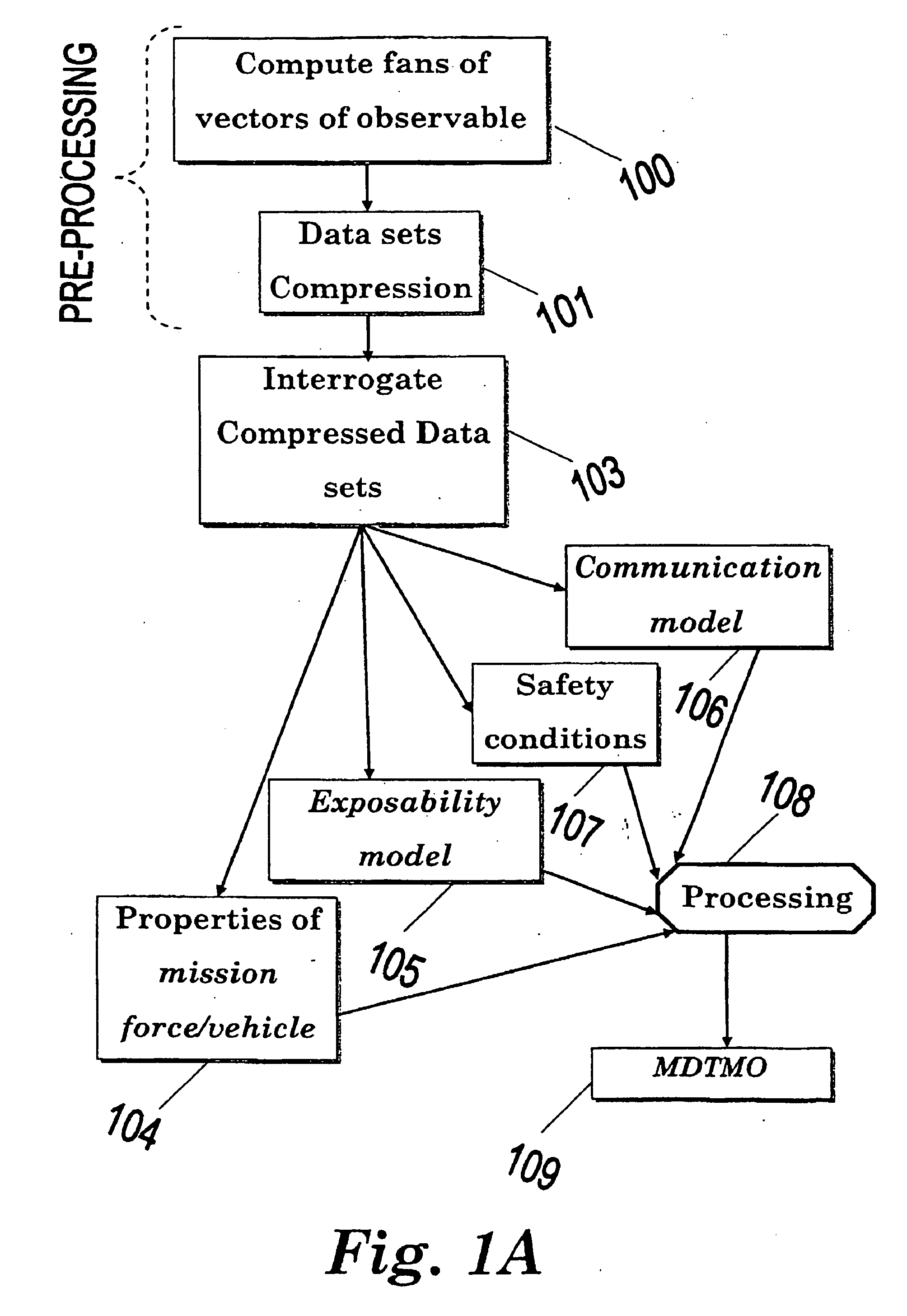
[0049] The present invention is directed to the generation of Mission Digital Terrain Models (MDTMO) required for mission planning, based on the generation of a particular, simplified, and compressed mission model which is created according to mission parameters and terrain information. According to a preferred embodiment of the invention the Digital Terrain Elevation Data (DTED) is utilized to extract an exposability model and a communication model, based on pre-processed directional fans of exposable vectors, which are then combined and processed into a MDTMO, which may be then efficiently used to effectively analyze terrain data with respect to mission specific parameters, in real time.

[0050] As will be explained in details hereinafter, the exposability DTMO is extracted from pre-processed directional fans of vectors of exposable heights, which are analyzed according to mission specific parameters (e.g., azimuth of approach), to reveal exposability DTMO points which satisfy the ...


PUM


Abstract

A method for processing and analyzing digital terrain data utilizing Digital Terrain Elevation Data (DTED). The method comprises defining approach azimuth and visibility limitations angle which are used for defining directional fans by determining fan opening angle, fan azimuth, and maximal range for terrain analysis. At least one directional fan data set is constructed from at least one source point within the DTED, where the directional fan includes line of sight information between said source point and DTED points located within said directional fan. The method further comprises interrogating said data sets by one or more queries to obtain terrain information for given approach conditions.

Description

FIELD OF THE INVENTION [0001] The present invention relates to the fields of data processing, mission planning, mission execution, and Digital Terrain Modeling (DTMO). More particularly, the invention relates to a method and apparatus for processing and analyzing Digital Terrain Elevation Data (DTED) for mission planning and on-line re-planning. BACKGROUND OF THE INVENTION [0002] Digital Terrain Elevation Data (DTED) generally consists of a two-dimensional array of terrain elevation points, each of which specifies the height of a terrain point above sea level. Therefore, it constitutes a convenience terrain map for computer representation and analysis. Unlike regular topographic maps, which represent terrains by continuous contour lines of equal heights, a DTED is, composed of equally distant terrain elevation points, and is analyzed and processed for construction of Digital Terrain Models (DTM) according to the specific requirements of the particular intended use. [0003] For instan...

Claims


Application Information

Patent Timeline
Patent Type & Authority Applications(United States)
IPC IPC(8): G06F19/00F41G7/34G01B21/00G01C21/00G05D1/06G06FG06T15/40
CPCG01C21/005G01C21/20
Inventor MOSCOVITZ, YIGALVICHIC, SERGEYATTIA, MICHELBEN-ARI, RAMI
Owner THE STATE OF ISRAEL MINIST OF AGRI & RURAL DEV AGRI RES ORG ARO VOLCANI CENT
Why Eureka
Try Eureka