Map evaluation system and map evaluation method

a mapping evaluation and map technology, applied in the field of mapping evaluation systems and map evaluation methods, can solve the problem that the accuracy of already stored road data cannot be increased

Inactive Publication Date: 2007-08-23
DENSO CORP
View PDF10 Cites 44 Cited by
  • Summary
  • Abstract
  • Description
  • Claims
  • Application Information

AI Technical Summary

Problems solved by technology

However, this system is intended to add new road data different from the road data already stored in the information center, and not to

Method used


Image

  • Map evaluation system and map evaluation method
  • Map evaluation system and map evaluation method
  • Map evaluation system and map evaluation method

Examples


Embodiment Construction

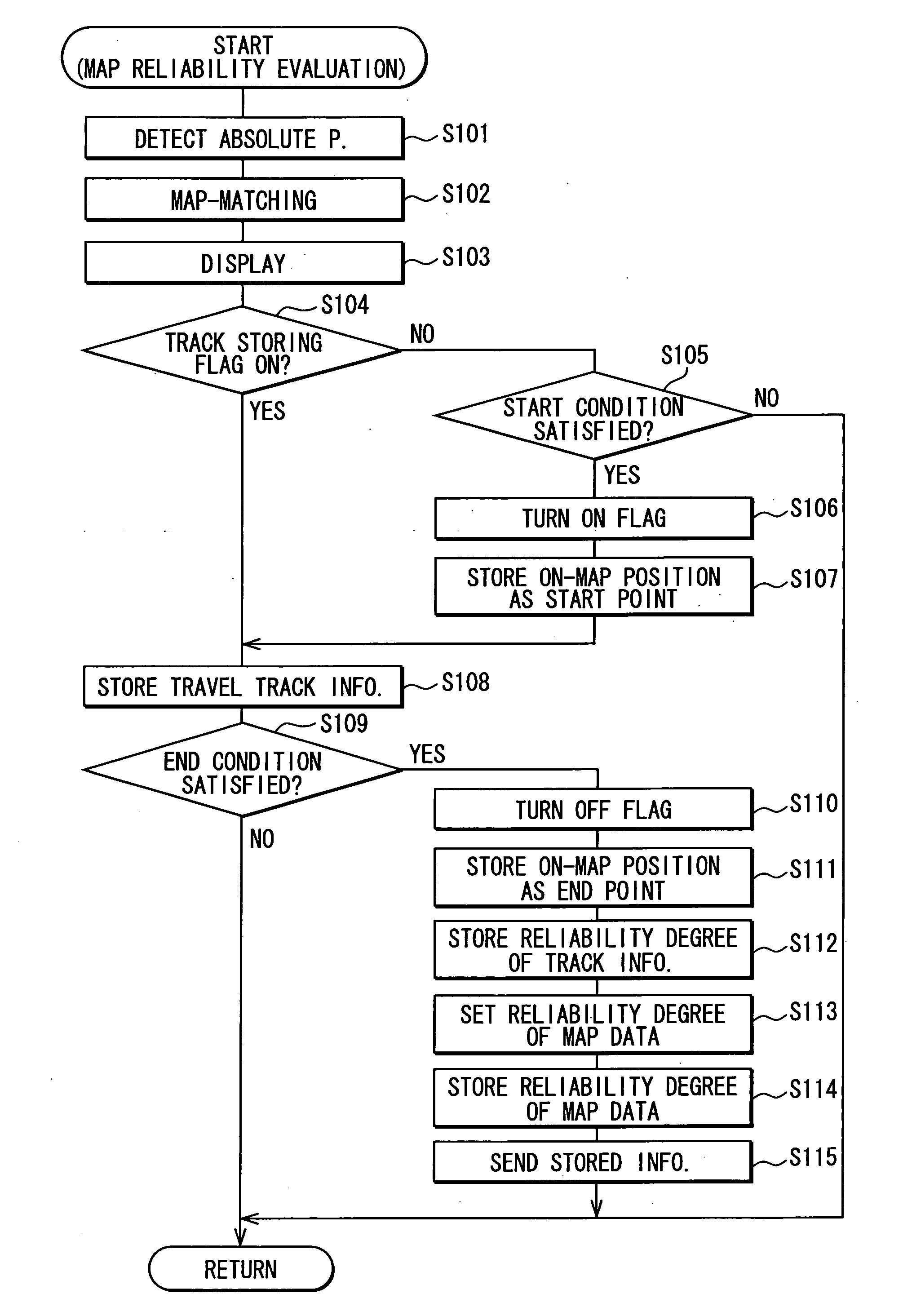
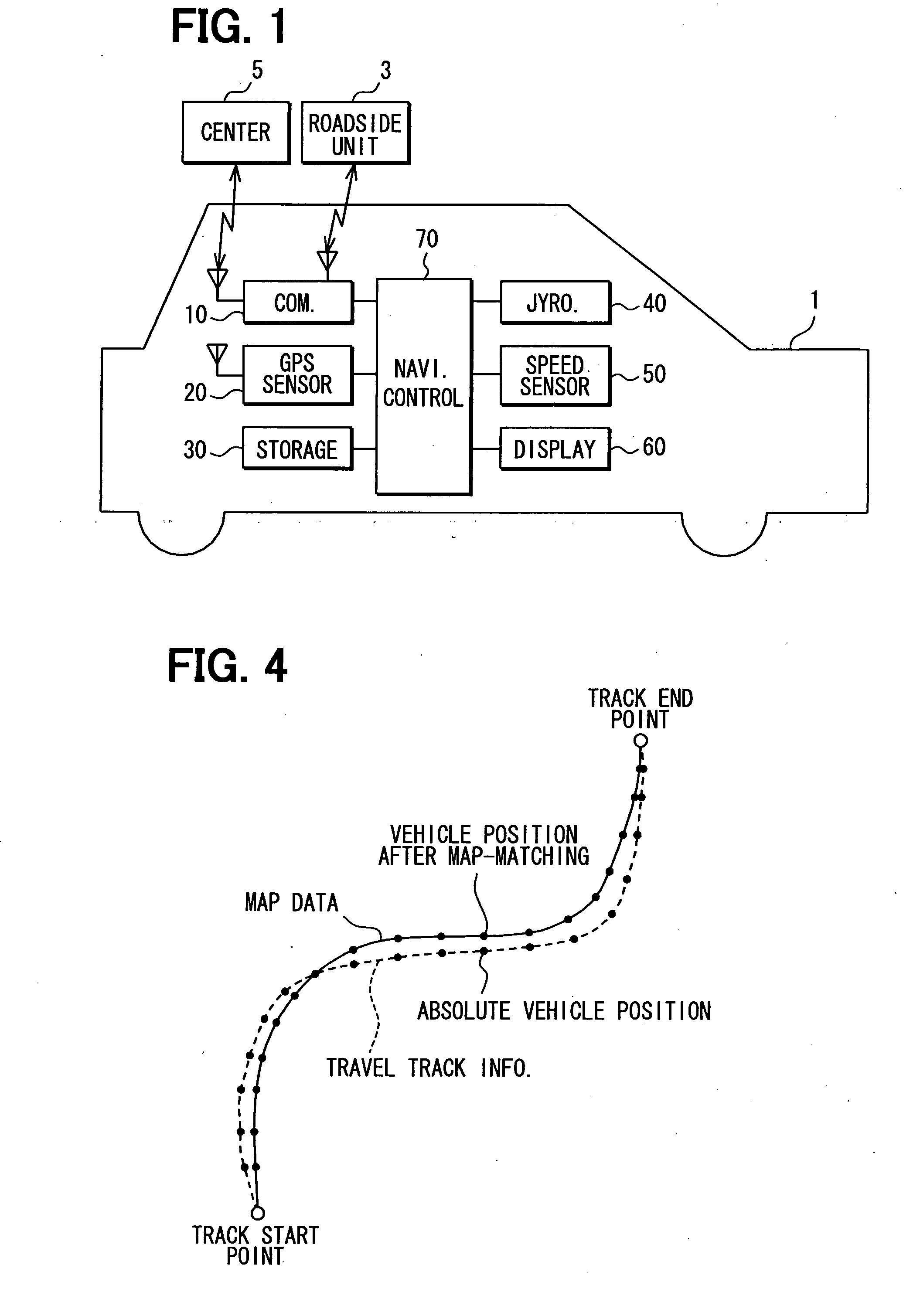
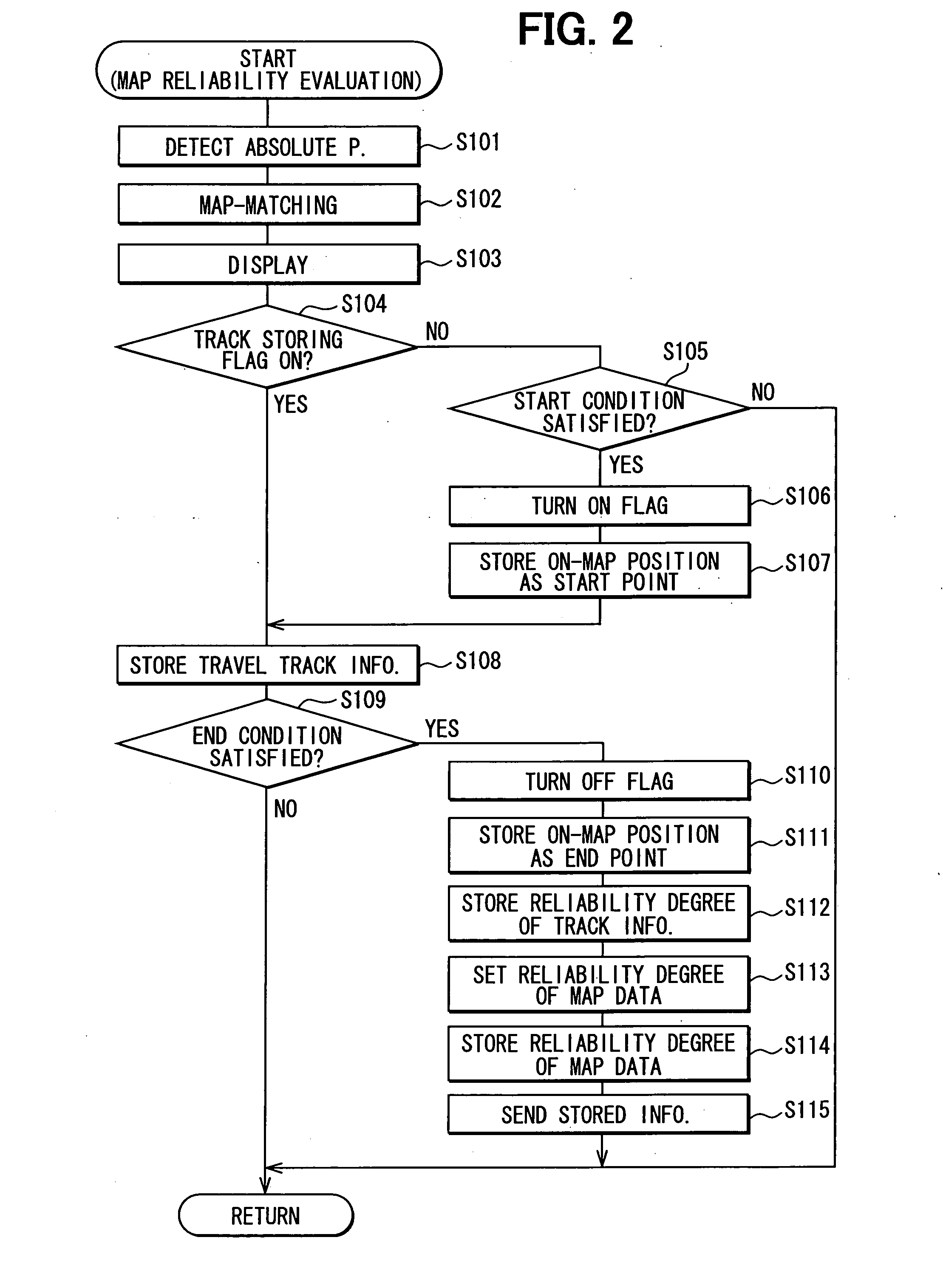
[0015]A navigation device will be explained as an embodiment to which a map evaluation system of the present invention is adapted. An overall structure of the navigation device is illustrated in FIG. 1. The navigation device, which is mounted in a subject vehicle 1 as one of multiple vehicles 1, includes a communications unit 10, a GPS sensor 20, a storage unit 30, a gyro sensor 40, a speed sensor 50, a display unit 60, and a navigation control unit 70. Here, the GPS sensor 20, the gyro sensor 40, and the speed sensor 50 function as absolute position acquisition means.

[0016]The communications unit 10 receives information from one of roadside units 3, which are individually located along roads, via a short range wireless communications. The communications unit 10 further communicates with a center 5 as an external server, which collects information from the navigation device, via a communications network such as the Internet. The roadside unit 3 sends, to the navigation device, infor...


PUM


Abstract

An absolute position detector of a navigation device detects an absolute position of a vehicle. An on-map position of the vehicle is acquired based on the detected absolute position to be on a road map indicated by map data stored in the navigation device. Absolute positions detected by the absolute position detector are stored in association with on-map positions acquired based on the detected absolute positions as travel track information when the vehicle travels. An error of the map data as a reliability degree of the map data is set by comparing the travel track information with the map data.

Description

CROSS REFERENCE TO RELATED APPLICATION[0001]This application is based on and incorporates herein by reference Japanese Patent Application No. 200642181 filed on Feb. 20, 2006.FIELD OF THE INVENTION[0002]The present invention relates to a map evaluation system and a map evaluation method for evaluating a reliability degree of map data used in a navigation device or the like.BACKGROUND OF THE INVENTION[0003]A navigation device displays a current position of a subject vehicle on a road map indicated by map data based on an absolute position detected. This absolute position is detected by using both (i) absolute measurement data based on a satellite navigation method using a GPS sensor and (ii) relative measurement data based on a dead-reckoning navigation method using a gyro sensor, a speed sensor, or the like. Here, if a road map indicated by the map data has an error against the real road, an absolute position of the vehicle does not match with the road map indicated by the map data....

Claims


Application Information

Patent Timeline
IPC IPC(8): G01C21/30G01C21/00G01S19/14G01S19/49G01S19/50G08G1/0969G09B29/00G09B29/10
CPCG01C21/30
Inventor YAMADA, KAZUNAO
Owner DENSO CORP
Why Eureka
Try Eureka