Method and apparatus for merging multiple road map databases

a technology of road map database and merged database, applied in the field of road map databases, can solve the problems of incomplete navtech data set, inability to provide complete and accurate coverage for any significant portion of the united states, and extremely sparse coverage of local roads

Inactive Publication Date: 2003-05-13
TELECOMM SYST INC
View PDF2 Cites 34 Cited by
  • Summary
  • Abstract
  • Description
  • Claims
  • Application Information

AI Technical Summary

Problems solved by technology

However, no provider is known to provide coverage that is both complete and accurate, for any significantly-sized portion of the United States.
However, NavTech's data set is not complete.
Most of the land area of the United States has only partial coverage by NavTech, with data covering only the main highways and extremely sparse coverage of local roads.
However, the incompleteness of the NavTech data set can create customer dissatisfaction.
Customer dissatisfaction can lead to a sign...

Method used


Image

  • Method and apparatus for merging multiple road map databases
  • Method and apparatus for merging multiple road map databases
  • Method and apparatus for merging multiple road map databases

Examples


Embodiment Construction

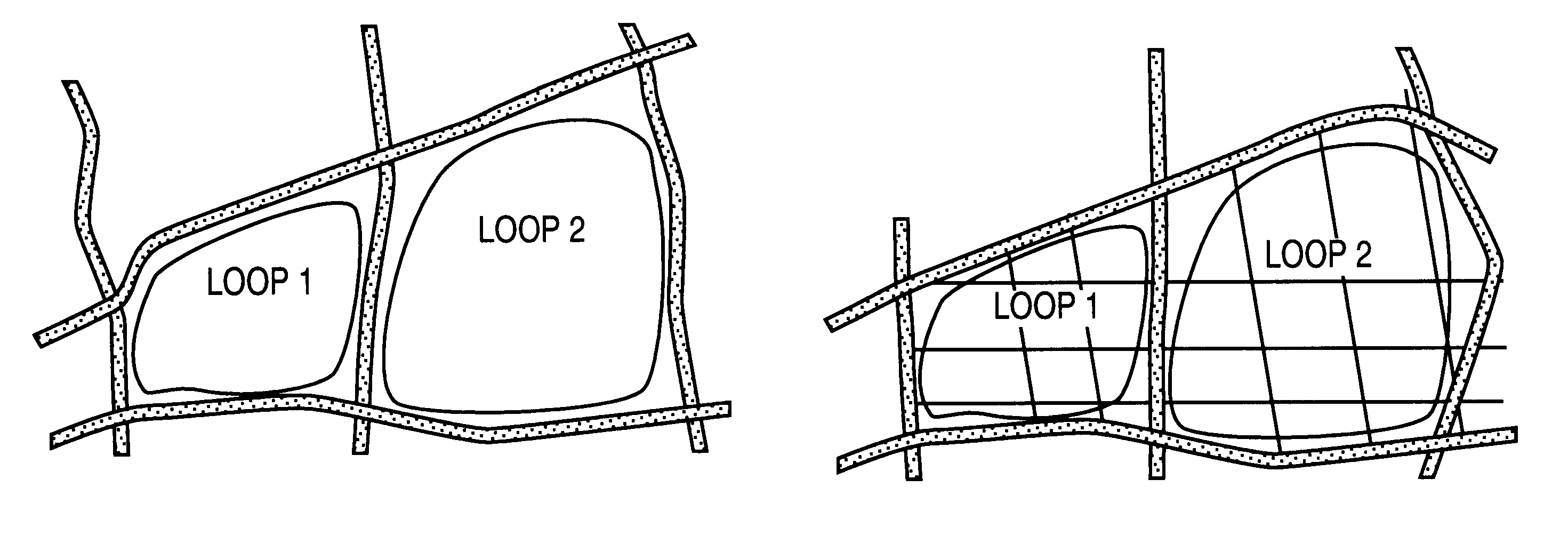
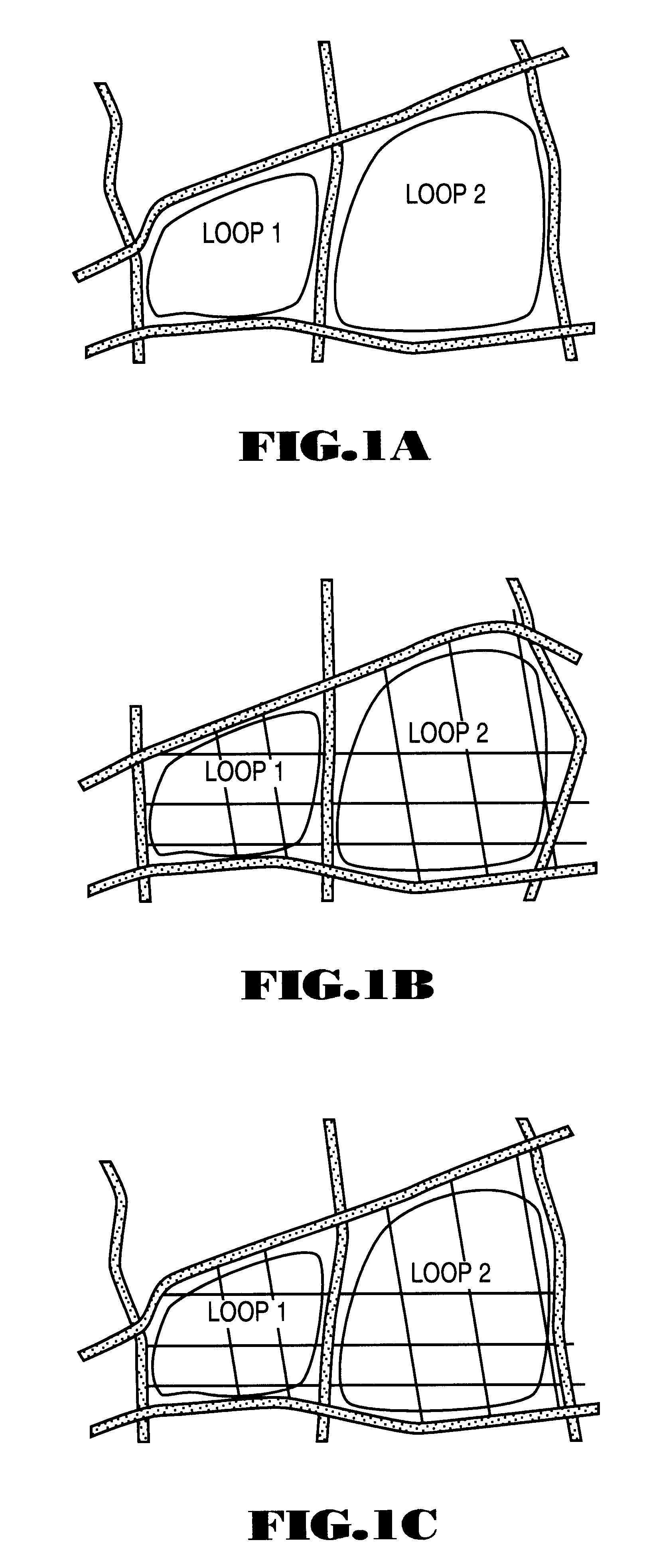
A method and apparatus for combining two road map databases of a geographic region are described. The two road map databases differ in degree of coverage of the geographic region or accuracy of coverage of the geographic region, or both. The described technique can be used to merge the two data sets of two vendors to produce a data set that takes advantage of one vendor's more complete coverage of a geographic region and the second vendor's greater accuracy. In effect, the technique "sews" the data sets together like a patchwork quilt.

I. Overview

As will be described in greater detail below, an embodiment of the technique is as follows: A first set of loops is defined from roads represented in a first of the two road map databases. For each of the first set of loops, a corresponding loop is identified from roads represented in a second of the two road map databases, to define a second set of loops. Each loop of the second set of loops may include one or more links, each of which repr...


PUM


Abstract

A method and apparatus for combining two dissimilar road map databases of a given geographic region are provided. The road map database differ in degree of coverage or accuracy of coverage, or both, of the geographic region. Each database includes data defining a plurality of roads. A first set of loops is defined from roads represented in a first of the two road map databases. For each of the first set of loops, a corresponding loop is identified from roads represented in a second of the two road map databases, to define a second set of loops. Each loop of the second set of loops may include one or more links, and each link represents a portion of a road represented in the second road map database. A set of output loops corresponding to the first set of loops is generated to form an output road map database. Links enclosed within loops of the second set of loops and not represented in the first road map database are then copied into the set of output loops, such that the output road map database represents a combination of the first road map database and the second road map database.

Description

FIELD OF THE INVENTIONThe present invention relates to road map databases for use by map-generation and route-finding devices and the like. More particularly, the present invention relates to techniques for combining multiple road map databases into a single combined database.BACKGROUND OF THE INVENTIONMap generation and route-finding devices and services are becoming increasingly more common and are gaining widespread use in daily life. Common examples of such devices and services are automobile-based and hand-held navigation systems and Internet-based mapping and route-finding services. It is desirable to have the most complete road data as possible for use with such devices and services. Road map data for use in such systems currently is available from more than one provider. However, no provider is known to provide coverage that is both complete and accurate, for any significantly-sized portion of the United States.Two well-known providers of road map data are Navigation Technol...

Claims


Application Information

Patent Timeline
IPC IPC(8): G01C21/32G01C21/28
CPCG01C21/32Y10S707/99948Y10S707/99945G01C21/387G01C21/3815
Inventor WU, XIAOYICOLLIER, W. CLAYTONSYNGHAL, RAJIV K.WHITAKER, JAMES
Owner TELECOMM SYST INC
Why Eureka
Try Eureka