Road map management system

Inactive Publication Date: 2007-02-08
DENSO CORP
View PDF10 Cites 38 Cited by
  • Summary
  • Abstract
  • Description
  • Claims
  • Application Information

AI Technical Summary

Benefits of technology

[0007] It is an object of the present invention to provide a road map management system to manage road map data by detecting a change in a road when a road is opened, closed, or modified and by reflecting on the existing road map data the detected change in roads to upd

Problems solved by technology

Road map data may be created using an aerial photograph or on-site survey result, which needs considerable costs and time.
If a road management entity does not report a road change such as road opening or road closing, the road map data fails to continue to have a practical use.
Therefore, it is very difficult to accurately determine whether a vehicle

Method used


Image

  • Road map management system
  • Road map management system
  • Road map management system

Examples


Embodiment Construction

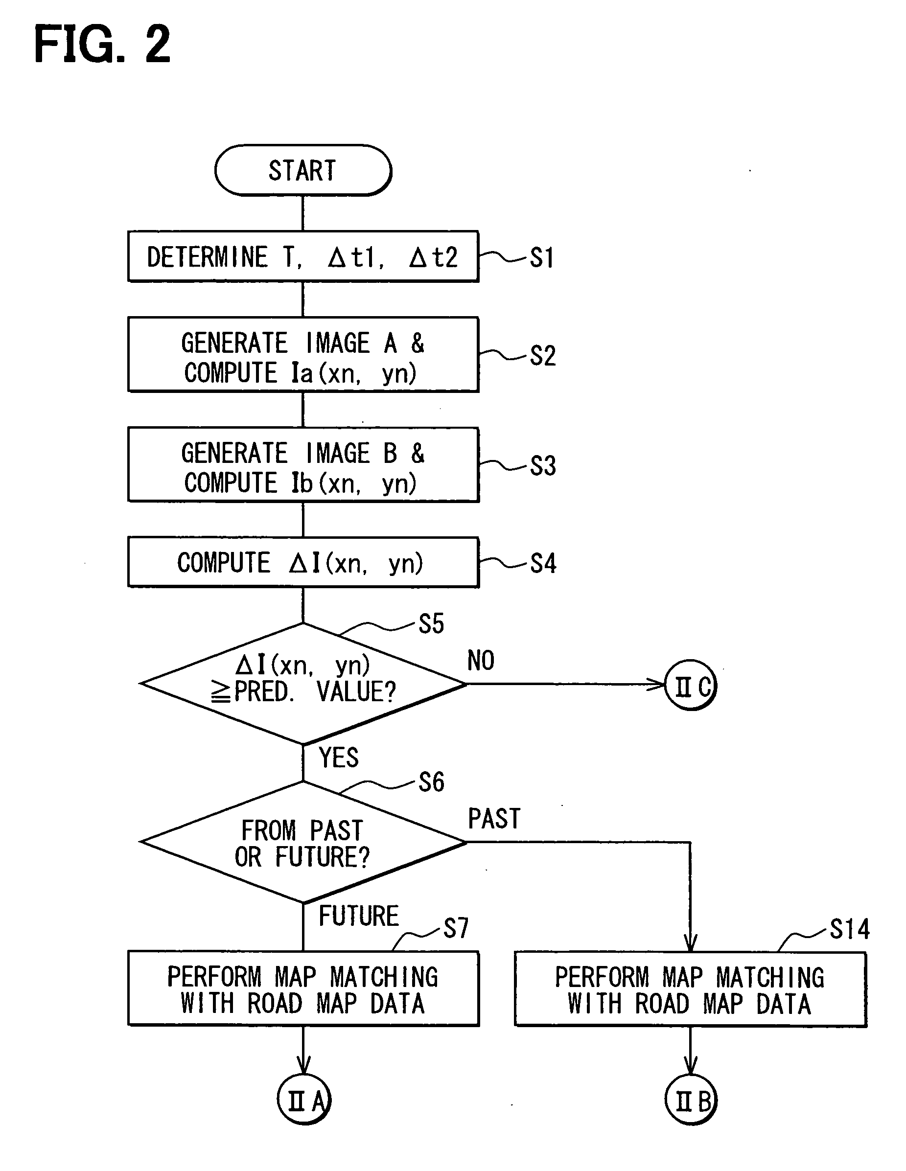
[0025] As an example of an embodiment according to the present invention, a road map management system will be explained with drawings. The road map management system may function as a road detection system and a road map data update system. Traveling position data has errors or encounters noises, evenly in any data collection period. It is assumed that computing difference between data collection periods enables errors to cancel each other.

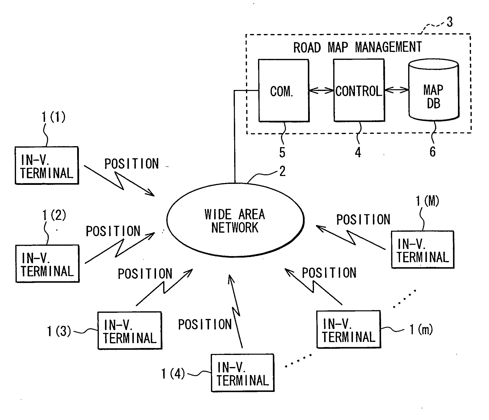
[0026] A road map management system 3 and its peripherals are shown in FIG. 1. Each of multiple in-vehicle terminals 1(m) (m=1 to M) is mounted in an individual subject vehicle, and has a floating car data collection (FCD) function. For instance, each terminal 1(m) transmits traveling position data via a wide area network 2 to the road map management system 3 each time the corresponding subject vehicle travels a predetermined travel distance or each time a predetermined time period elapses. The traveling position data represents a traveling posi...


PUM


Abstract

A road map management system is provided as follows: drawing a past-direction distribution map (Image A) and a future-direction distribution map (Image B) using multiple vehicles' traveling position data collected via a wide area network during a past-direction data collection period and a future-direction data collection period, respectively; comparing the two distribution maps to extract a differential distribution; defining under a predetermined condition as a recently opened or closed road the differential distribution, which is absent from Image A and present in Image B, or present in Image A and absent from Image B, respectively; and reflecting the defined results on the existing road map data to update.

Description

CROSS REFERENCE TO RELATED APPLICATIONS [0001] This application is based on and incorporates herein by reference Japanese Patent Application No. 2005-225427 filed on Aug. 3, 2005. FIELD OF THE INVENTION [0002] The present invention relates to a road map management system, also functioning as a road detection system and road map data update system, to manage road map data by detecting a change in roads when a road is opened, closed, or modified. BACKGROUND OF THE INVENTION [0003] Road map data may be created using an aerial photograph or on-site survey result, which needs considerable costs and time. If a road management entity does not report a road change such as road opening or road closing, the road map data fails to continue to have a practical use. [0004] Patent document 1 discloses a method for updating road map data using navigation devices mounted in vehicles. The navigation device detects a fact that a vehicle track departs from the road indicated by the road map data and s...

Claims


Application Information

Patent Timeline
IPC IPC(8): G01C21/32
CPCG01C21/32G09B29/00G08G1/0969G01C21/3844G01C21/3815G01C21/3841G01C21/3859G01C21/26G08G1/0104G01C21/3848
Inventor GOTO, MASAYUKIYAMADA, SHINICHI
Owner DENSO CORP
Why Eureka
Try Eureka