Object identity and location tracking system

a tracking system and object technology, applied in the field of objects, can solve the problems of large, more expensive systems for tracking the position of delivery trucks, and poor suited to use on smaller objects, and achieve the effects of improving the accuracy of the detection and detection process, and improving the accuracy of detection and detection

Inactive Publication Date: 2008-03-06
PINPOINT PRODIONS L L C AN OKLAHOMA LIMITED LIABILITY
View PDF42 Cites 53 Cited by
  • Summary
  • Abstract
  • Description
  • Claims
  • Application Information

AI Technical Summary

Benefits of technology

[0012]The object identity and location tracking system described in the present disclosure and claimed herein utilizes at least one locator unit and at least one display unit. The locator unit is attached to the object to be tracked and determines the position of the object as follows. A receiver in the locator unit receives satellite position data from a satellite positioning system such as GPS, GLONASS, LORAN, or GALILEO. The locator system measures local position data using one or more sensors such as an accelerometer and a compass. The satellite position data is then augmented with the local position data to generate the current position of the object. Augmented position data and a unique locator ID are then transmitted wirelessly, for example via an RF communications transceiver, to all display units operating on a group ID.

Problems solved by technology

Larger, more expensive systems exist for tracking the position of delivery trucks and the like.
These systems largely rely on vehicle power systems and are thus poorly suited to use on smaller objects.
One especially problematic application of such a system is for tracking relatively small objects or animals, such as domestic pets, hunting dogs, or livestock, which may move in a nearly infinite combination of directions and distances.
Several significant problems remain with the above mentioned systems.
Measuring the strength of radio frequencies is relatively inaccurate and makes it extremely difficult to calculate or display direction of travel.
Further, radio frequency systems are not well suited to differentiating between multiple objects or uniquely identifying such objects.
Positioning systems which rely solely on GPS or other satellite data are susceptible to inconsistent performance in treed or overgrown areas where the GPS receiver cannot maintain simultaneous line-of-sight communication with at least three satellites.
Systems mounted on shorter animals, such as hunting dogs, are even more susceptible to interruption since bushes and tall grasses may obscure the GPS receiver.

Method used


Image

  • Object identity and location tracking system
  • Object identity and location tracking system
  • Object identity and location tracking system

Examples


Embodiment Construction

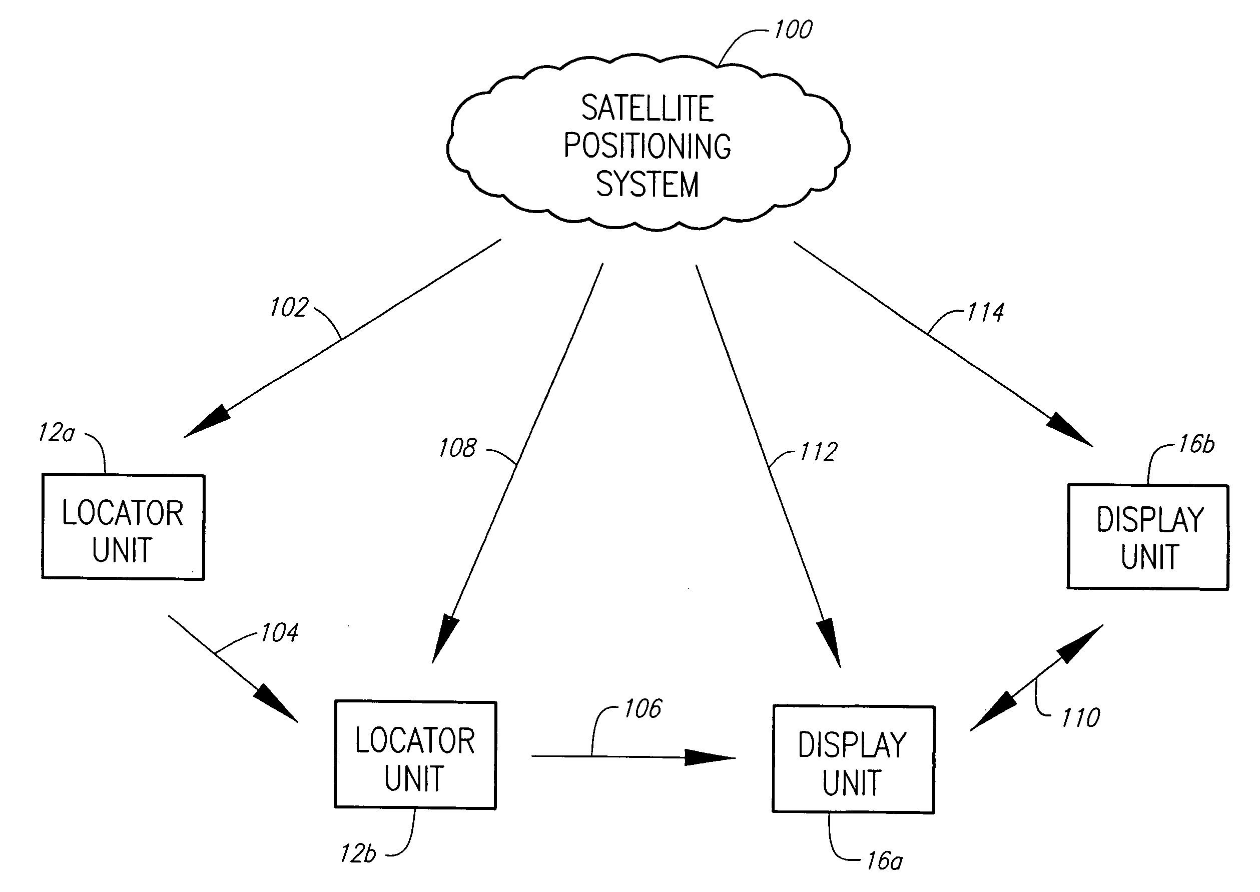
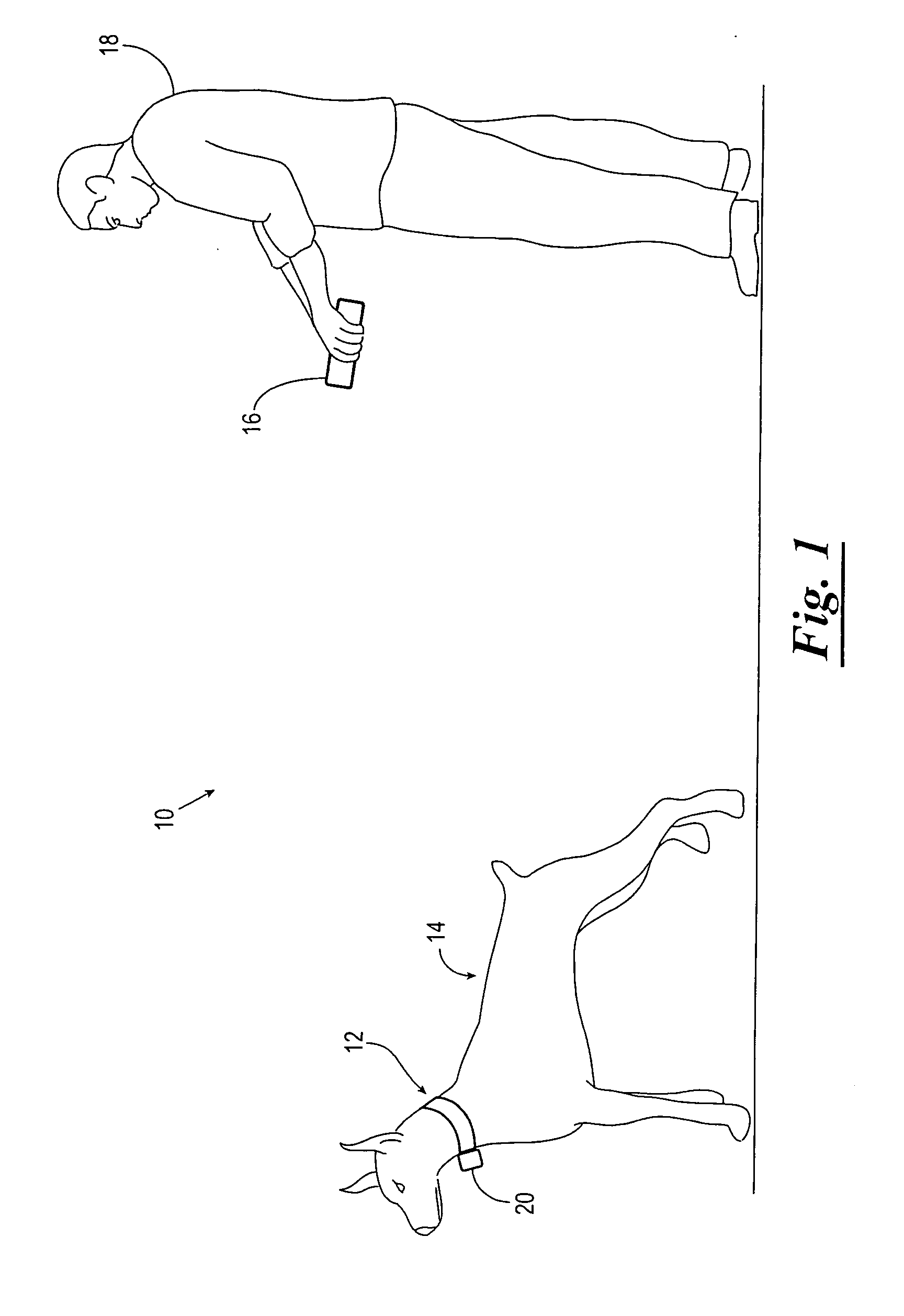
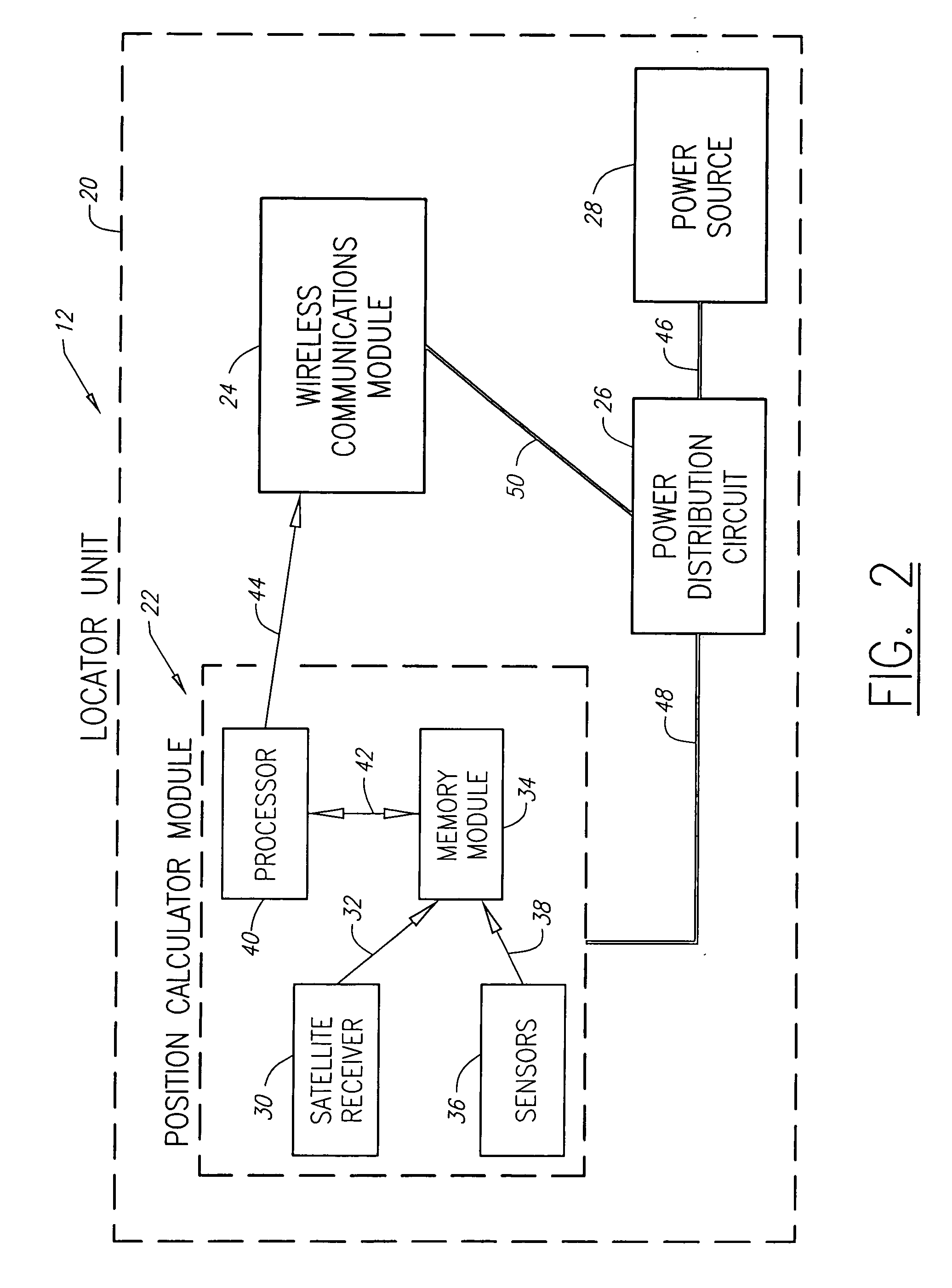
[0019]Referring now to the drawings and more particularly to FIG. 1, an object identity and position tracking system 10 (hereinafter referred to as the system) is shown. The system 10 includes one or more locator units 12, each attached or coupled to an object 14 such as a dog, child, person, car, or the like; and one or more display units 16, each disposed so as to be available to a user 16. The locator unit 12 calculates the position of the object 14 by obtaining satellite position data through known satellite positioning methods. The locator unit 12 then measures local position data, augments the satellite position data with local position data, and outputs augmented position data to the display unit 16.

[0020]The display unit 16 calculates its own position using a similar method and receives the augmented position data from the locator unit 12. The display unit 16 then outputs the position of the locator unit 12 to the user 18 via a user interface. The position of the locator uni...


PUM


Abstract

A system and method for tracking the identity and position of an object. The system includes at least one locator unit that is attached to the object to be tracked. The system also includes at least one display unit carried by or with a user. The locator unit obtains its satellite position data from a satellite positioning system such as GPS, GLONASS, LORAN, GALILEO, or the like. The locator unit then measures local position data with one or more sensors such as accelerometers and compasses and augments the satellite position data with the local position data. The locator unit transmits the augmented position data to a display unit. The display unit calculates its own position in the same way and outputs the augmented position of the locator unit relative to the augmented position of the display unit via a user interface.

Description

CROSS REFERENCE TO RELATED APPLICATIONS[0001]Not applicable.BACKGROUND OF THE INVENTION[0002]1. Field of the Invention[0003]This invention relates generally to a system for identifying and locating an object. More specifically, but not by way of limitation, this invention relates to an electronic system utilizing one or more sensors to measure the motion of an object and augment satellite position data obtained with known satellite positioning methods.[0004]2. Brief Description of Related Art[0005]In recent years, numerous systems and methods have been proposed and developed for tracking the location of an object. Larger, more expensive systems exist for tracking the position of delivery trucks and the like. These systems largely rely on vehicle power systems and are thus poorly suited to use on smaller objects.[0006]One especially problematic application of such a system is for tracking relatively small objects or animals, such as domestic pets, hunting dogs, or livestock, which ma...

Claims


Application Information

Patent Timeline
Patent Type & Authority Applications(United States)
IPC IPC(8): G01S5/14G08B1/08G01S19/48G01S19/13G01S19/49G01S19/51
CPCA01K11/008A01K15/021G01S19/51G01S19/13G01S19/49G01S5/0027
Inventor HENSLEY, CHARLES R.JONES, CHARLESMORAVEC, KIPTON
Owner PINPOINT PRODIONS L L C AN OKLAHOMA LIMITED LIABILITY
Why Eureka
Try Eureka