System for remote data geocoding

a geocoding and remote data technology, applied in the field of geographic information analysis, can solve the problems of more difficult to determine the spatial relationship between the geographic locations specified in the two disparate data sets, the inability to integrate the geographic data from these web sites into a single, unified data set, and the “wholesale” downloading of their geographic data sets. the effect of complexity and knowledg

Inactive Publication Date: 2008-06-05
FIRST AMERICAN REAL ESTATE SOLUTIONS
View PDF6 Cites 51 Cited by
  • Summary
  • Abstract
  • Description
  • Claims
  • Application Information

AI Technical Summary

Benefits of technology

[0030]In accordance with yet another feature of the present invention, a Web-based data source may be capable of generating geographically-registered images where certain pixels of these images are set to known values, thereby designating specific geographic locations. Images in this format can be advantageously used to perform well-known Boolean algebra operations on a per-pixel basis so as to determine spatial relationships with geographical data contained in other images. Alternatively, this image data can also be used to perform calculations in a Cartesian space aligned with the 2D image.
[0031]In accordance with yet another feature of the present invention, the system may be implemented as a remote Web service, thereby allowing users to perform geographic information processing without the expense, complexity and knowledge required to install, use and maintain GIS software.

Problems solved by technology

However, where the location of the building is stored in a first data set, and where the boundaries of the earthquake-susceptible area are stored in a second, disparate data set, it is more difficult to determine the spatial relationship between the geographic locations specified in the two disparate data sets.
However, there are several serious deficiencies to this “standard” approach for determining spatial relationships between geographic locations specified in a plurality of disparate data sets.
First, there are many data sources which only permit access to their geographic data sets via specific queries submitted through the Web.
Thus, these data sources prohibit “wholesale” downloading of their geographic data sets and instead only provide the geographic data in response to specific queries received through the Web.
Thus, it is difficult to incorporate the geographic data from these Web sites into a single, unified data set.
Second, the geographic data present in many data sources may not be in a format which is conducive to performing a desired geographic analysis and, in any case, the geographic data present in the disparate databases may not be in a unified data format.
However, this is frequently not the case.
Geographic data (in this case wetlands area information) is available via the aforementioned Web site, but the Web site provides only a limited set of tools for utilizing this data.
By way of example but not limitation, the aforementioned Web site does not provide any way for a user to query whether a specific geographic location is located within a wetlands area.
Furthermore, there is currently no convenient way to take the geographically-registered images of the aforementioned Web site and use them in a coordinated fashion with additional data held in another, disparate data set, e.g., which uses a different data format.
By way of example but not limitation, there is currently no convenient way to take the geographically-registered images of the aforementioned Web site and use them in combination with another data set (e.g., a portfolio of insured properties specified in longitude / latitude coordinates) so as to determine spatial relationships between the geographic locations specified by the two disparate data sets (e.g., to determine whether a portfolio of insured properties has any structures located within a wetlands area).

Method used


Image

  • System for remote data geocoding
  • System for remote data geocoding
  • System for remote data geocoding

Examples


Embodiment Construction

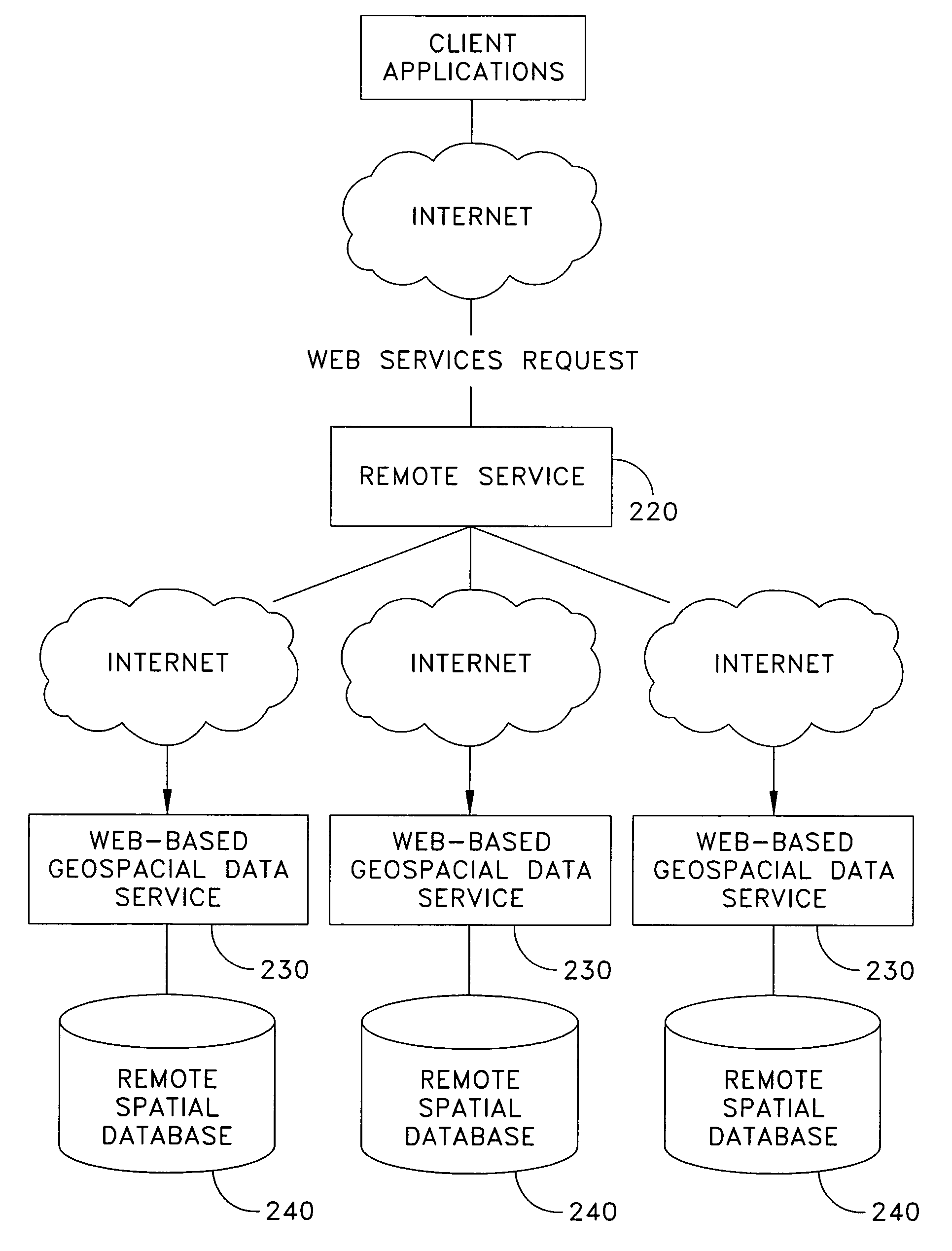
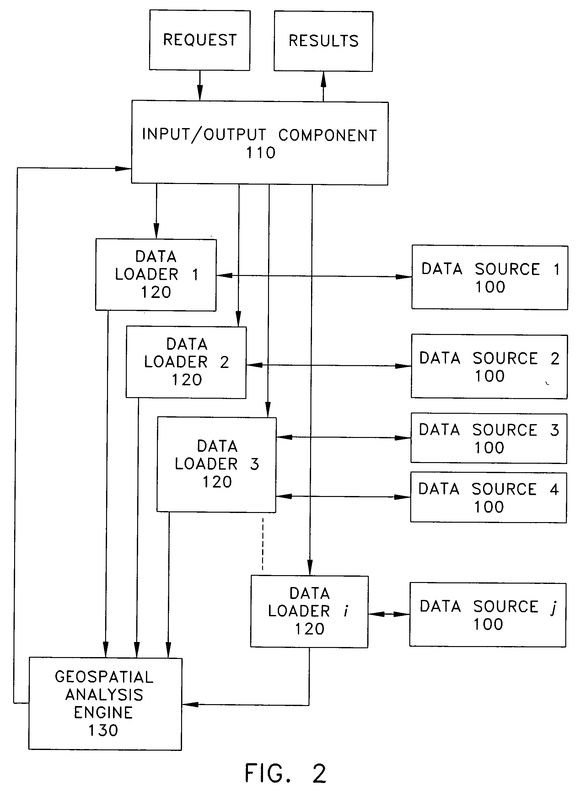
[0064]The present invention is directed to a system for (i) accessing geographical data residing in a plurality of disparate sets, (ii) establishing spatial registration between the geographic data residing in the disparate sets, and (iii) determining spatial relationships between geographic locations specified in the disparate data sets, where any or all of those datasets are remote from the user.

[0065]Referring now to FIG. 2, there is shown a novel system formed in accordance with the present invention. The access addresses for the data sources 100 specified by the user (e.g., URL addresses) are received by the input / output component 110. The access address for each user-specified data source 100 is passed to a data loader component 120. Each data loader component 120 determines what data formats can be provided by its associated data source 100 and then determines the format or formats which are best suited for performing the desired spatial analysis. The data loader component 12...


PUM


Abstract

A system for accessing geographical data residing in a plurality of disparate data sets and determining spatial relationships between geographic locations specified in the disparate data sets, the system comprising: an accessing component for accessing geographical data residing in a plurality of disparate data sets; a registration component for establishing spatial registration between the geographical data residing in the disparate data sets; and a geospatial analysis engine for determining spatial relationships between geographic locations specified in the disparate data sets.

Description

REFERENCE TO PENDING PRIOR PATENT APPLICATION[0001]This patent application claims benefit of pending prior U.S. Provisional Patent Application Ser. No. 60 / 816,158, filed Jun. 23, 2006 by James Aylward for REMOTE DATA GEOCODING (Attorney's Docket No. HDM-7 PROV), which patent application is hereby incorporated herein by reference.FIELD OF THE INVENTION[0002]This invention relates to the analysis of geographic information in general, and more particularly to (i) establishing spatial registration between the data sets of a plurality of disparate geographic information data sources, and (ii) determining spatial relationships between geographic locations specified in the disparate data sets of the plurality of geographic data sources.BACKGROUND OF THE INVENTION[0003]A rich variety of data exists regarding geographic information. Examples of this geographic information include property locations, outlines of real estate parcels, locations of hazard areas, etc.[0004]Users of this geographi...

Claims


Application Information

Patent Timeline
Patent Type & Authority Applications(United States)
IPC IPC(8): G06F17/30G06F40/00
CPCG06F17/30265G06F17/30241G06F16/29G06F16/58
Inventor AYLWARD, JAMES A.DEMPSTER, DOUGLAS G.
Owner FIRST AMERICAN REAL ESTATE SOLUTIONS
Why Eureka
Try Eureka