Manoeuvre and safety system for a vehicle or an installation

a safety system and vehicle technology, applied in the field of vehicles or installations, can solve the problems of not being able to investigate the object further, not being able to give the end-user a quick overview of the heading, and not being able to meet the needs of conventional interfaces and end-user details,

Active Publication Date: 2009-10-29
FLIR SYST LTD
View PDF7 Cites 167 Cited by
  • Summary
  • Abstract
  • Description
  • Claims
  • Application Information

AI Technical Summary

Benefits of technology

[0014]Consequently, the system according to the invention provides a system for obtaining, processing and presenting 3D data sets. It also allows the data to be updated with time, and time therefore provides a fourth dimension.

Problems solved by technology

However, even if the data is presented together, it is typically only combined on a display and the data from the different sensors is typically not processed together.
Moreover, the user-friendliness of conventional interfaces and the detail of the information provided to the end-user are often not satisfactory.
However, there is no possibility of investigating the object further such as investigating whether the object is a buoy or a swimmer.
Moreover, the screen does not typically give the end-user a quick overview of the heading and speed of the object in relation to the ship.
Forward-looking sonar heads have now been developed but they do not provide depth data coherently with range and bearing information.
However, various objects can approach the ship without being detected by these systems, particularly in fog, during the night or when the objects approach below the surface of the water.
Traditional sensors and instrumentation on marine vessels do not adequately protect goods and people.
They are not capable of detecting, tracking and providing details about events such as goods and people falling overboard.

Method used


Image

  • Manoeuvre and safety system for a vehicle or an installation
  • Manoeuvre and safety system for a vehicle or an installation
  • Manoeuvre and safety system for a vehicle or an installation

Examples


Embodiment Construction

System Structure

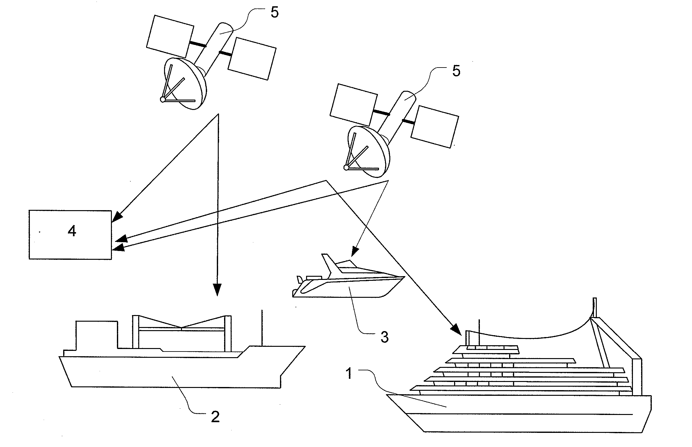
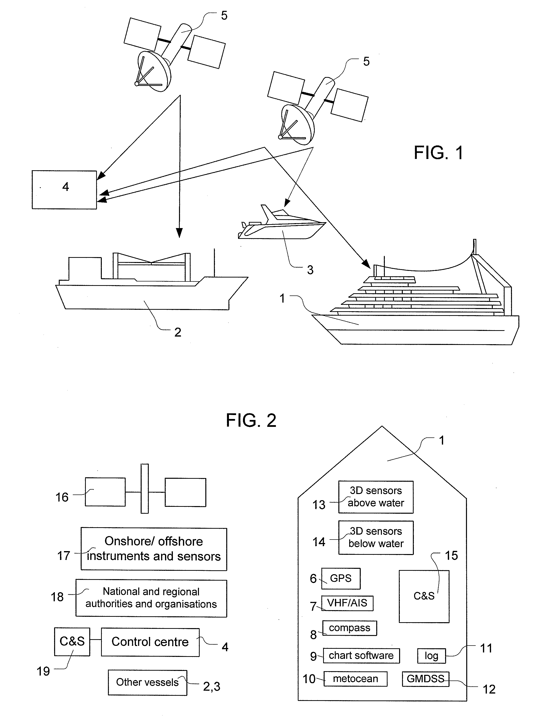
[0052]FIGS. 1 and 2 illustrate a system, which provide a security, safety, navigation, and anti-collision tool for marine vessels. The system includes at least one marine vessel 1, 2 and 3, such as a cruise ship 1, an oil / gas tanker / floating production unit 2, or a pleasure boat 3. It could also include a control centre 4 in communication with the at least one of the marine vessels via a communication link. The communication link may be provided as a satellite link via one or more communication satellites 5. The link may also be a wireless link to the Internet. The control centre 4 receives marine meteorological and oceanographic (metocean) data and ship information from a number of external information sources. Metocean data includes sea state data, such as wind, current and wave data, and sea ice state data, such as ice concentration, ice drift, ice edge and iceberg data. The vessels receive information from a number of sources, including the control centre 4, that...


PUM


Abstract

A system for a vehicle is provided for allowing a user of the vehicle or installation to obtain advanced and up-to-date information about the surroundings of the vehicle or installation and the vehicle or installation itself. The system may be located on a marine vessel and it integrates information from a number of different information sources, located both on and off the vessel, en including information from advanced radar and sonar subsystems on the ship, information from conventional instruments and sensors and information from onshore and offshore installations and EO satellites accessed via a control centre onshore. The system may communicate with the control centre via a communication satellite and/or wireless Internet, if available. A data processing apparatus for processing and presenting the data is also provided. The data is received, processed and presented in three dimensions in space and updated in real time or near real time such that time provides a fourth dimension to the data. A graphical user interface for presenting the data is also provided. The graphical user interface provides functionality for reporting an error in the system if the end user's own observations do not match the presented data. Additionally, a system for collecting data comprising more than one ship, the control centre and means for the ships and the control centre to communicate is provided. The system comprises a catalogue and storage network for storing collected data. All data is stored with an associated quality measure of the data.

Description

TECHNICAL FIELD[0001]The invention relates to system for a vehicle or an installation. More particularly, but not exclusively, it relates to maneuvering, safety and security apparatus for a marine vessel, oil / gas production platform or harbour, which integrates information from a number of different information sources, both on and off the vehicle or installation, and presents the information to the end-user using a graphical user interface. The invention also relates to a system for communicating and storing the information.BACKGROUND OF THE INVENTION[0002]Instruments of different technological complexities can be used to navigate at sea. The most basic navigational tools include nautical charts in paper form, compasses and basic speed meters on the ship, while the more complex tools include chart plotters linked to GPS receivers and interfaces for connecting to Satcoms and / or for connecting to the Internet to obtain up-to-date metrological data.[0003]Usually, a separate user inter...

Claims


Application Information

Patent Timeline
Patent Type & Authority Applications(United States)
IPC IPC(8): G08G3/02G01S13/937
CPCG01S13/9307B63G2009/005G01S13/862G08G3/02G01C21/005G01S13/937G01S13/86
Inventor DOKKEN, SVERRE THUNE
Owner FLIR SYST LTD
Why Eureka
Try Eureka