Method and System for Assessing Insurance Risk

Inactive Publication Date: 2010-03-18
METROPOLITAN PROPERTY & CASUALTY INSURANCE
View PDF13 Cites 40 Cited by
  • Summary
  • Abstract
  • Description
  • Claims
  • Application Information

AI Technical Summary

Benefits of technology

[0008]It is a further object of the invention to eliminate significant diff

Problems solved by technology

The current method does not reflect the fact that expected losses may v

Method used


Image

  • Method and System for Assessing Insurance Risk
  • Method and System for Assessing Insurance Risk
  • Method and System for Assessing Insurance Risk

Examples


working example

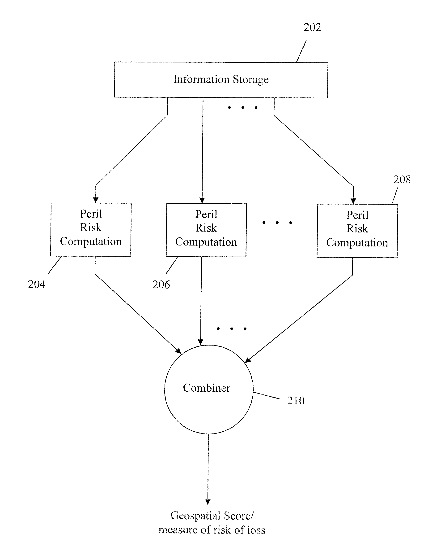
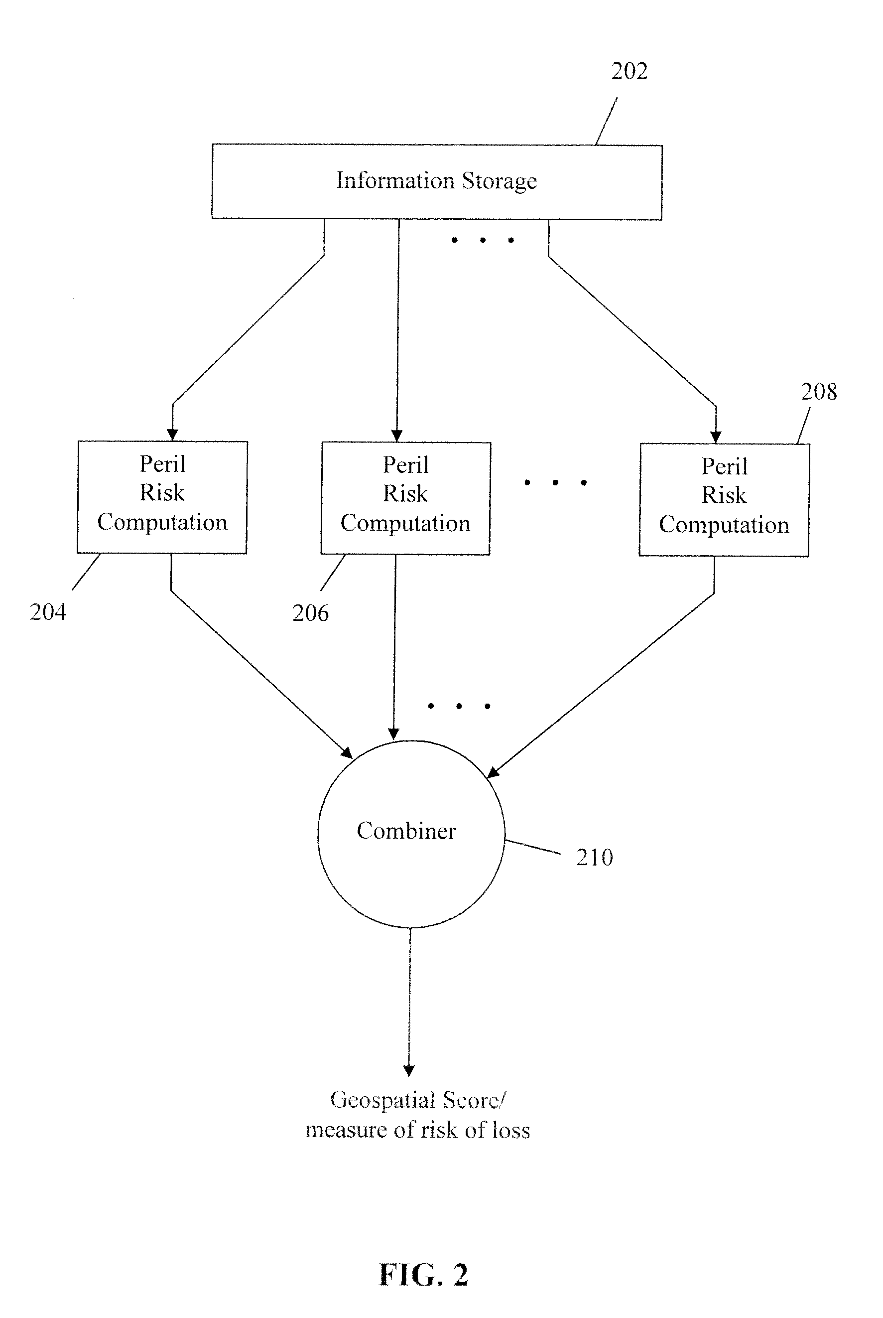
Example of the Improved Match of Risk to Rate Using Geospatial Score Technology

[0038]Although current actuarial ratemaking methodologies used for the pricing of homeowners insurance in the United States include a geographical component, almost all personal lines insurers incorporate geography by varying price by rating territory. These rating territories are typically defined by groupings of zip codes. Zip codes are grouped together based on similar expected loss costs (expected losses for an individual exposure for a policy term). The loss costs used for grouping zip codes are usually on an all perils combined basis. As such, the mix of historical losses by the covered peril is implicitly built into the territorial rates. However, differences do exist in expected loss costs from one property to another within a zip code, due to the differences in risks associated with the topography of the land where the properties are located. The disclosed technology reflects these differences in...


PUM


Abstract

The disclosed technology provides systems and methods for estimating the risk of loss for a location. A computer implemented method in accordance with the disclosed technology accesses one or more geographical characteristics associated with a geographical address, considers a plurality of perils and for each peril, computes a corresponding measure of peril that indicates a risk of loss at the geographical address from that peril. The corresponding measure of peril is computed based on the geographical characteristic(s) associated with the geographical address. The individual measures of peril are combined to form a combined measure that indicates a combined risk of loss at the geographical address from the plurality of perils. In one embodiment, the combined measure is used to compute an insurance premium for property at the geographical address. The disclosed technology also includes a computer executing software, wherein the executed software causes the computer to perform the steps above.

Description

CROSS-REFERENCE TO RELATED APPLICATIONS[0001]This application claims the benefit of priority of U.S. Provisional Patent Application No. 61 / 045,231 filed Apr. 15, 2008, the entire contents of which are hereby incorporated herein by reference.FIELD OF INVENTION[0002]The invention relates generally to methods for using Geocoded data pertaining to the physical environment in combination with historical insurance data to develop more accurate and efficient methods for insurance claim risk assessment at an individual risk level that can be used for more accurately pricing and underwriting insurance. Geocoded data is information assigned to specific geographic locations. More effective individual level risk assessment for an exact location can be accomplished by using the Geocode of the particular location to link risk attributes of various types for the location with historical insurance data. This linked information is then analyzed and an enhanced risk assessment is developed (“Geospati...

Claims


Application Information

Patent Timeline
IPC IPC(8): G06Q40/00G06Q50/00
CPCG06Q40/08G06Q40/02
Inventor DEEDE, MARTIN W.JENNINGS, PHILIP J.MCMICHAEL, DAVID
Owner METROPOLITAN PROPERTY & CASUALTY INSURANCE
Why Eureka
Try Eureka