Report generation for a navigation-related database

a technology of navigation-related database and report generation, applied in the field of geodata and navigation, can solve the problems of errors in geographic data collection, inability to collect geographic data in time, and time-consuming initial collection of road data in a geographic area

Active Publication Date: 2014-11-04
HERE GLOBAL BV
View PDF36 Cites 31 Cited by
  • Summary
  • Abstract
  • Description
  • Claims
  • Application Information

AI Technical Summary

Problems solved by technology

For example, the initial collection of data about the roads in a geographic area may be time consuming.
Also, geographic data used in navigation systems become out-of-date.
There also may be errors in collected geographic data.
Accordingly, end users who have navigation systems may discover that certain geographic data used in their navigation systems are not up-to-date, not correct, or not accurate.
Updating and checking the geographic data may involve significant efforts.

Method used


Image

  • Report generation for a navigation-related database
  • Report generation for a navigation-related database
  • Report generation for a navigation-related database

Examples


Embodiment Construction

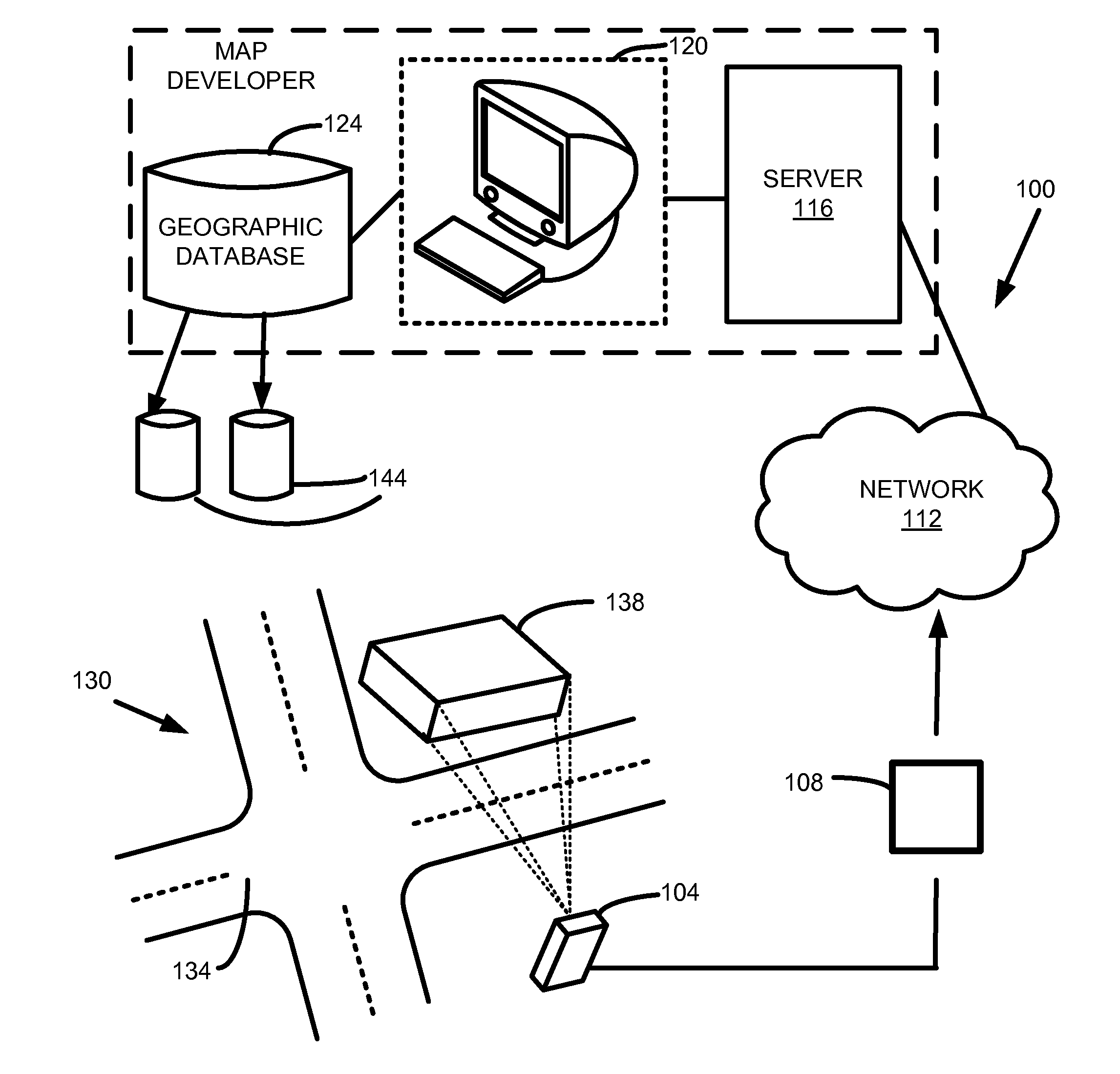
[0018]FIG. 1 shows one embodiment of a system 100 for updating a geographic database and / or reporting discrepancies regarding geographic data. The system 100 includes, but is not limited to, a user device 104, a network 112, a server 116, one or more workstations 120, and a geographic or navigation-related database 124. Additional, fewer, or different components may be provided. For example, a proxy server, a cache server or cache network, a base station, transceiver and / or broadcasting components, a router, a switch or intelligent switch, additional computers or workstations, administrative components, a gateway device, a backbone, ports, network connections, and network interfaces may be provided. While the components in FIG. 1 are shown as separate from one another, one or more of these components may be combined.

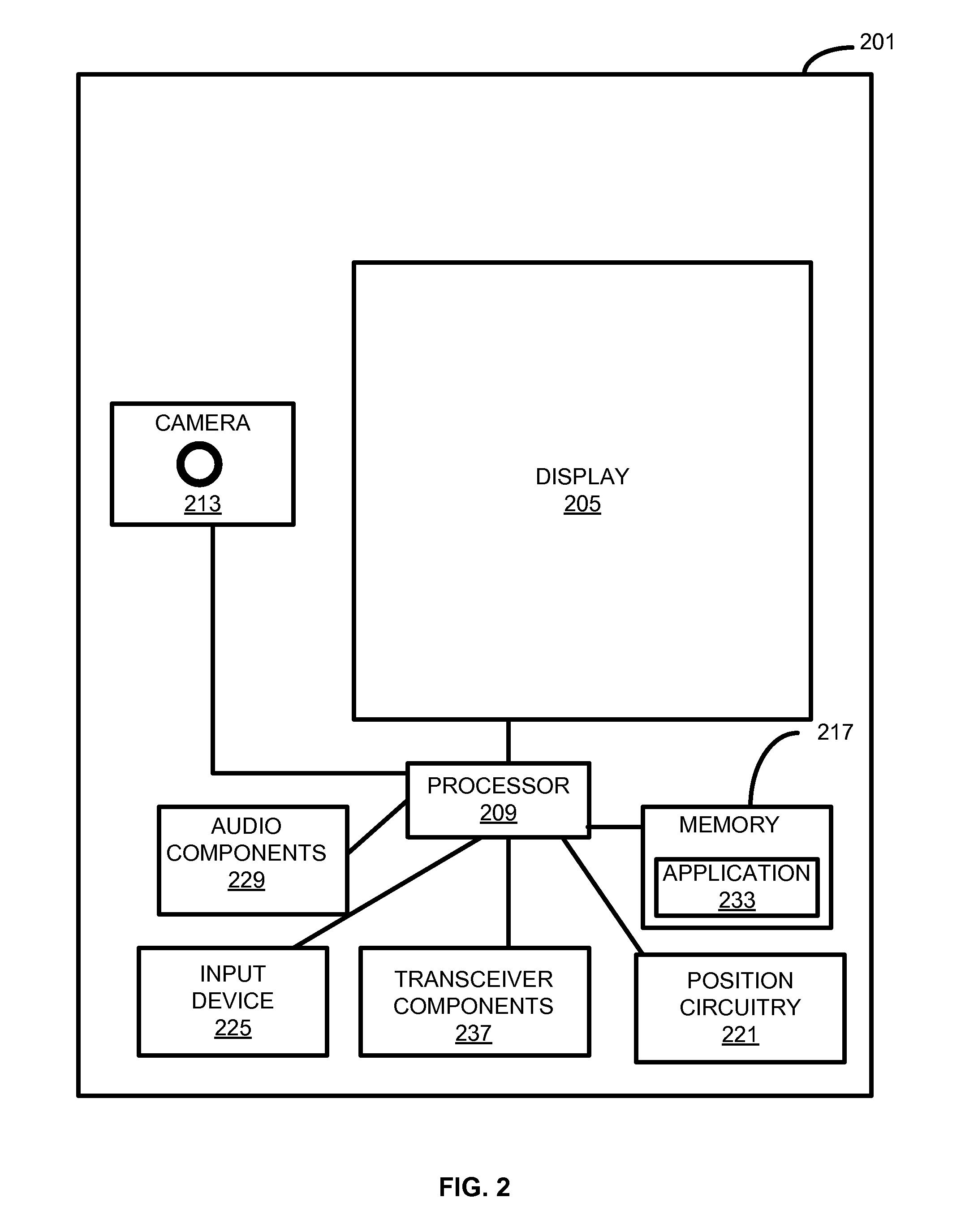
[0019]The user device is a cellular telephone, a mobile phone, a personal digital assistant (“PDA”), a watch, a camera, a computer, a personal navigation device (“PND”),...


PUM


Abstract

Systems, devices, features, and methods for updating a geographic database, such as a navigation-related database, and / or reporting discrepancies associated with geographic data of the geographic database are disclosed. For example, one method comprises capturing a photograph of an observed geographic feature in a geographic region. Comment information corresponding to the observed geographic feature may be stored. The comment information is indicative of a discrepancy between the observed geographic feature and the geographic data corresponding to the geographic region. The comment information may be associated with the photograph to generate a report, and the report is transmitted.

Description

BACKGROUND OF THE INVENTION[0001]The present invention relates to geographic data and navigation and, more particularly, to updating a navigation-related database and / or reporting discrepancies regarding geographic data.[0002]Navigation systems or devices provide useful features, such as calculating routes to desired destinations and providing guidance for following the routes. In order to provide these features, navigation systems use geographic data that include information about the locations of roads and intersections, estimated travel times along road segments, the speed limits along roads, etc.[0003]The collection of geographic data for use in navigation systems may be a significant undertaking. For example, the initial collection of data about the roads in a geographic area may be time consuming. Also, geographic data used in navigation systems become out-of-date. For example, new roads are built, businesses change locations, road construction closes roads, detours are establ...

Claims


Application Information

Patent Timeline
Patent Type & Authority Patents(United States)
IPC IPC(8): G06F17/30G01C21/32
CPCG06F17/30241G01C21/32G06F17/30386G06F17/30345G06F16/24G06F16/23G06F16/29G01C21/3811G01C21/3815G01C21/3848
Inventor PERCZYNSKI, DAVIDFINK, OLIVER
Owner HERE GLOBAL BV
Why Eureka
Try Eureka