Method for positioning by wi-fi signals
a technology of wi-fi signals and positioning systems, applied in the field of positioning systems, can solve the problems of damage to the positioning performance of the sps both in terms of availability and precision, and the positioning system is not, however, fully satisfactory, and achieves the effect of improving the positioning precision
- Summary
- Abstract
- Description
- Claims
- Application Information
AI Technical Summary
Benefits of technology
Problems solved by technology
Method used
Image

Examples
first embodiment
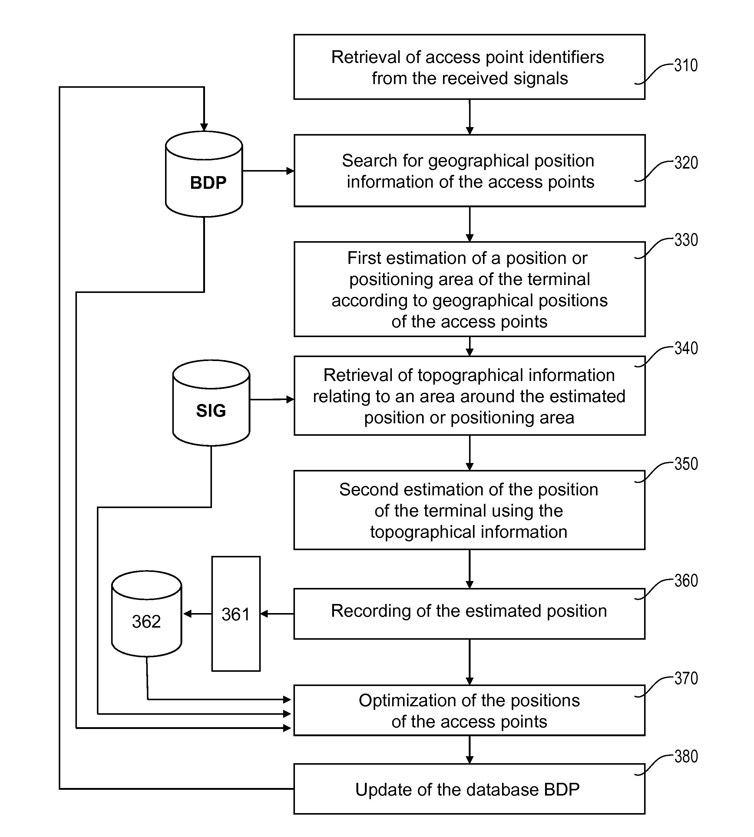
[0069]According to the invention, the topographical information from the database SIG is used to select the most appropriate positioning method from among: an access point positioning method (APPS), a satellite positioning system (SPS), or a hybrid positioning method, the latter itself being able to be broken down in the form of a so-called tight hybridization, i.e. occurring at the exploitation of the received signals (SPS and APPS) or a so-called loose hybridization, i.e. occurring at the positions obtained by said two methods. In the case where a hybrid positioning method is chosen, the topographical information from the database SIG is used to adjust the weighting coefficients applied to the positions obtained by the SPS and APPS methods in the case of loose hybridization, or applied to the measurements done using the SPS and APPS methods in the context of tight hybridization.
[0070]The selection can be done according to different criteria considered alone or in combination.
[0071...
second embodiment
[0079]According to the invention, the topographical information stored in the database SIG is used to determine the characteristics of the channel between each detected access point and the terminal, in particular the propagation coefficients and the delay times of the different paths. These characteristics make it possible to calculate the theoretical power that the terminal should receive at different points of the zone around its estimated position. Advantageously, this zone is meshed and a cost function depending on the deviations between received power and calculated power, for the different access points detected by the terminal, is minimized on the nodes of the mesh. For example, the cost function will be defined by a quadratic sum of said deviations. The second estimation of the position of the terminal is finally given by the position of the node minimizing said cost function.
third embodiment
[0080] the geographical positions of the different access points determined by the terminal are assigned uncertainty zone, determined as described in detail later. The geographical information of the database BDP then comprises, for each access point, its geographical position and the data defining the uncertainty zone for that position.
[0081]When the position of the terminal is determined by a barycentric calculation (received power, ratios between transmitted and received power), the weight coefficients can be modified by a corrective factor taking into account the size of the uncertainty zone. More specifically, the weight coefficient relative to an access point whereof the uncertainty zone is significant will be increased and that relative to an access point with a low uncertainty zone will be decreased in return. As a general rule, the weight coefficients will be defined by an increasing function of the transmission powers of the points and a decreasing function of the respecti...
PUM
 Abstract
Description
Claims
Application Information
 - R&D Engineer
- R&D Manager
- IP Professional
- Industry Leading Data Capabilities
- Powerful AI technology
- Patent DNA Extraction
Browse by: Latest US Patents, China's latest patents, Technical Efficacy Thesaurus, Application Domain, Technology Topic.
© 2024 PatSnap. All rights reserved.Legal|Privacy policy|Modern Slavery Act Transparency Statement|Sitemap