Method and system for localizing mobile communications terminals

a mobile communication terminal and geographic localization technology, applied in satellite radio beaconing, measurement devices, instruments, etc., can solve the problems of signal diffraction, gps signal received by gps receivers is highly attenuated, and gps signals are normally received at very low power levels, so as to improve the accuracy of position estimation, and accurately estimate the position of gnss receivers

Active Publication Date: 2013-10-10
TELECOM ITALIA SPA
View PDF2 Cites 21 Cited by
  • Summary
  • Abstract
  • Description
  • Claims
  • Application Information

AI Technical Summary

Benefits of technology

The technical effect of this patented technology lies with improving the performance of location determination systems used on satellites based on pseudorange measurement errors. By comparing different methods together they can make sure there are no differences or discrepancies from one another. This helps ensure good results even when combined into multiple algorithms.

Problems solved by technology

The patent text discusses the problem of accurately estimating the geographic position of mobile GPS receivers in urban environments. The text explains that the issue is caused by the obstacles that block the signals from GPS satellites, such as tall buildings and dense foliage. The text describes techniques for overcoming these obstacles by using a Gaussian model or the particle filter method. However, there are limitations in accurately estimating the error affecting the measurements. The text also discusses the importance of using an empirical model of the noise to improve accuracy. The text suggests that the accuracy of positioning in urban environments can be improved by analyzing the individual post-fit residuals and conducting statistical tests on the post-fit residuals. The text also mentions the use of the monte Carlo method and the importance of using the WLS method for assessing the quality of GPS fixes. The text also describes the use of the particle filter method for online non-linear tracking. The technical problem is to improve the accuracy of GPS positioning in urban environments.

Method used


Image

  • Method and system for localizing mobile communications terminals
  • Method and system for localizing mobile communications terminals
  • Method and system for localizing mobile communications terminals

Examples


Embodiment Construction

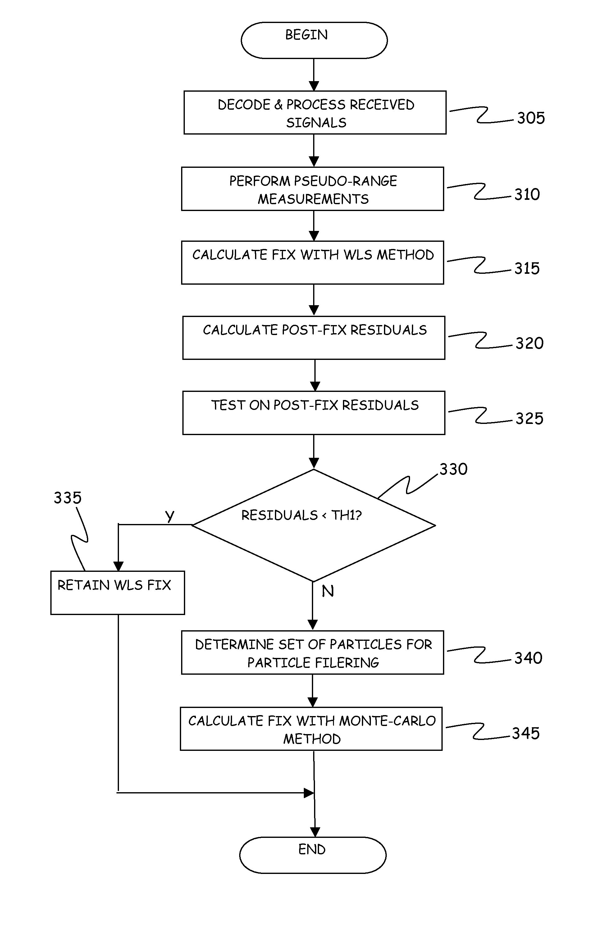
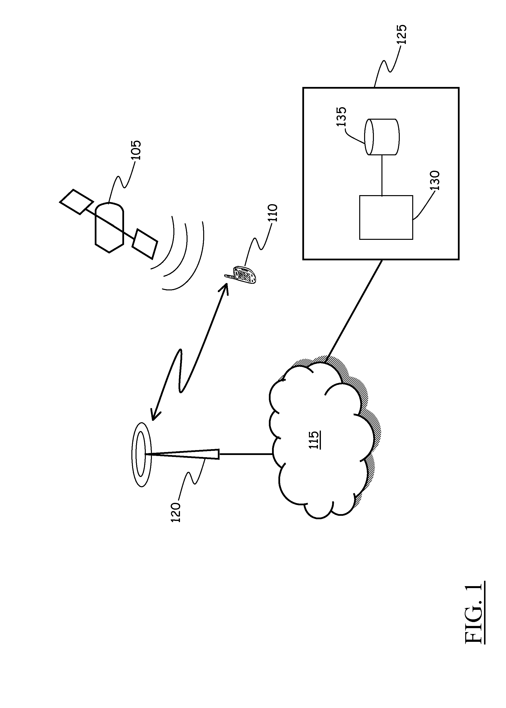
[0057]Referring to the drawings, FIG. 1 schematically shows the general architecture of a mobile communications terminal geolocation system according to an embodiment of the present invention.

[0058]Reference numeral 105 denotes a signal source, e.g. a transmitter transported by one of the plurality of satellite vehicles making up the constellation of satellite vehicles of a GNSS like the GPS. The signal source 105 is configured to transmit microwave radio carrier signals, at a prescribed frequency (e.g., the so-called “L1 frequency”), modulated (spread) by a unique scrambling code, uniquely assigned to that transmitter, and by data bits making up a navigation message. The navigation message transmitted by the generic transmitter includes inter alia the GPS satellite vehicle's orbit parameters (including the so-called “almanac” and “ephemeris”), clock corrections, and other parameters; all these data are useful for the receiver to calculate and update its location on the Earth surfac...


PUM


Abstract

A method of determining a geographic position of a user terminal including a receiver of signals of a global navigation satellite system, the method including the user terminal: performing pseudo-range measurements related to a plurality of signals received from transmitters of the global navigation satellite system; calculating a first estimated position thereof by a weighted least square method; calculating post-fit residuals for the first estimated position; comparing the calculated post-fit residuals to a first threshold and: in case the first threshold is exceeded, calculating a second estimated position using a Monte-Carlo method, otherwise retaining the first estimated position as the geographic position of the mobile communications terminal.

Description


Claims


Application Information

Patent Timeline
Owner TELECOM ITALIA SPA
Why Eureka
Try Eureka