Method, apparatus and system for mapping a course of a mobile device

a mobile device and navigation system technology, applied in the field of navigation systems, can solve the problems of difficulty in retracing, difficulty in retracing, and difficulty in retracing,

Active Publication Date: 2014-03-27
INTEL CORP
View PDF12 Cites 26 Cited by
  • Summary
  • Abstract
  • Description
  • Claims
  • Application Information

AI Technical Summary

Problems solved by technology

However, such functionality of existing navigation systems is of little or no use in certain everyday situations for users of mobile devices.
For example, people visiting large or complex buildings (e.g. shopping malls, convention centers, hospitals, etc.) quite often find it difficult to remember a course by which they came into the building and/or a course taken within the building during some period of time.
Moreover, such courses are often arbitrary—e.g. where the user does not plan the course prior to or even during traversal—and do not follow any particular predetermined route (or predetermined component route) along a road, walkway, etc.
Furthermore, people navigati

Method used


Image

  • Method, apparatus and system for mapping a course of a mobile device
  • Method, apparatus and system for mapping a course of a mobile device
  • Method, apparatus and system for mapping a course of a mobile device

Examples


Embodiment Construction

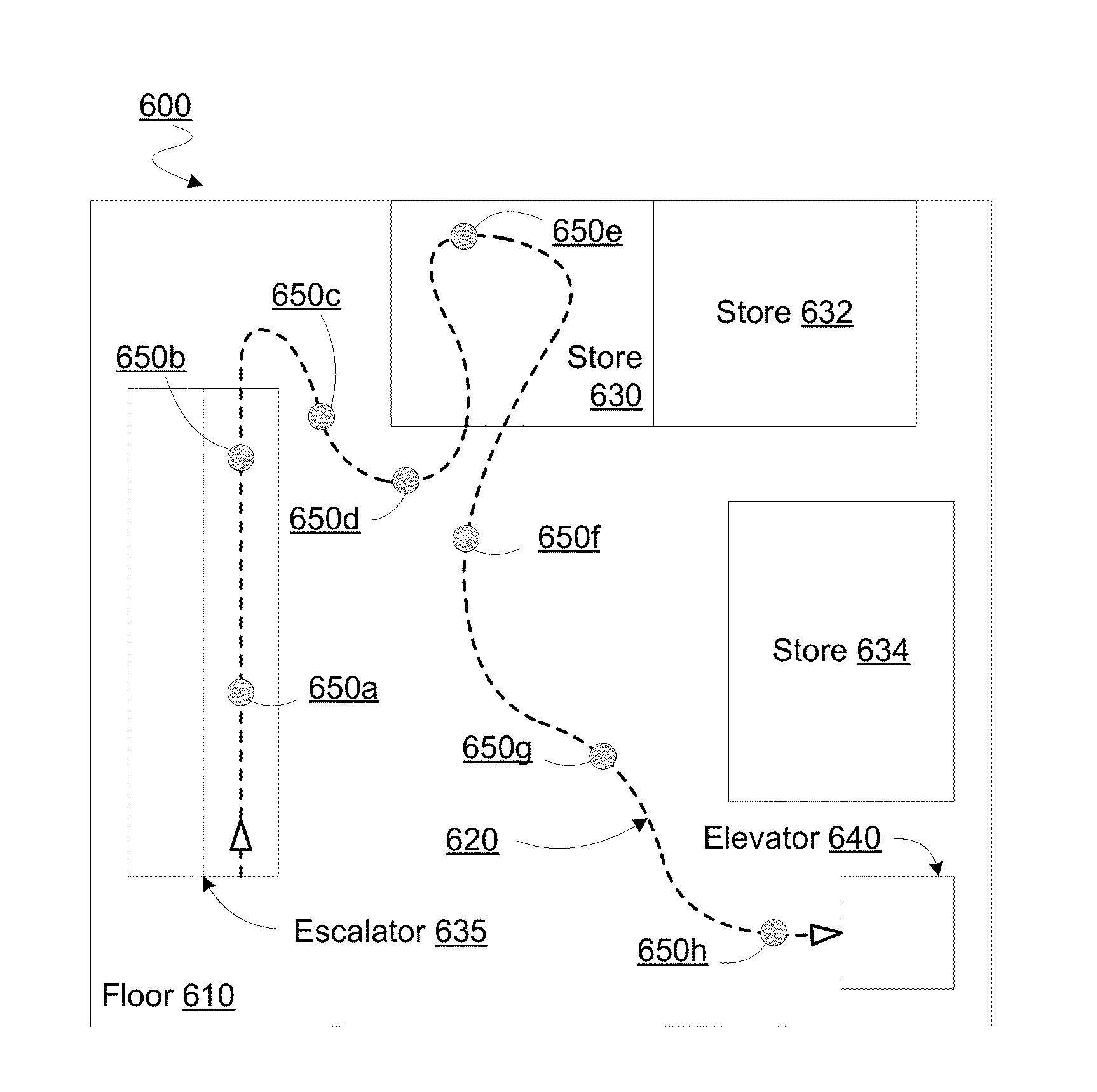
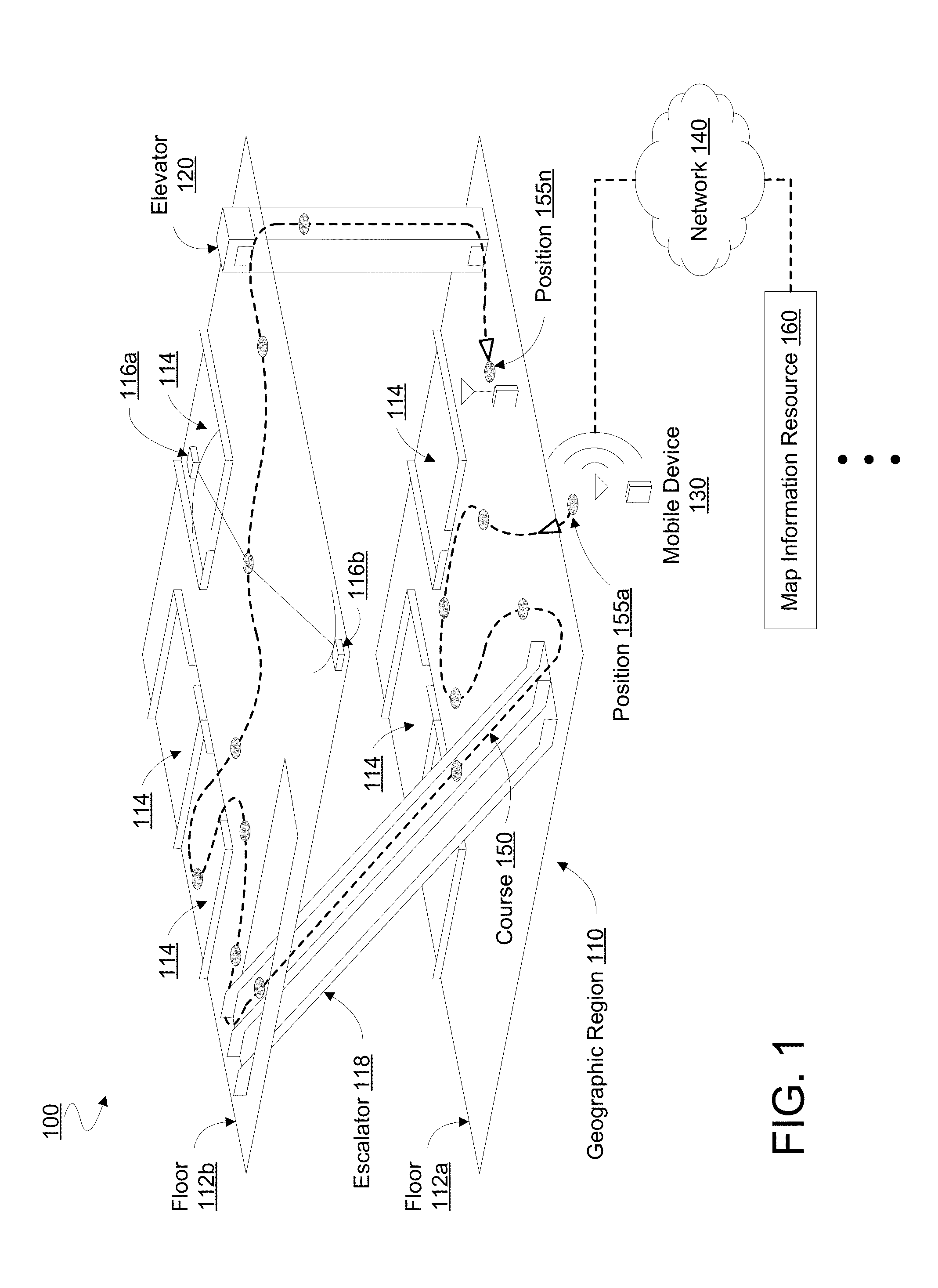
[0017]FIG. 1 illustrates elements of a system 100 for mapping a course of a mobile device according to an embodiment. To illustrate elements of various embodiments, certain elements of system 100 are shown operating in a geographic region 110. However, geographic region 110 may not itself be part of system 100. The size, geometry, location and other features of geographic region 110 are merely illustrative, and are not limiting on certain embodiments.

[0018]Geographic region 110 may include one or more man-made structures—e.g. including at least a portion of one or more floors of a commercial, residential, government or other building such as a store, office, mall, warehouse and / or the like. By way of illustration and not limitation, geographic region 110 may include floors 112a, 112b having various rooms 114 (e.g. stores, offices and / or the like) and an escalator 118 and / or elevator 120 for transportation between floors 112a, 112b. Geographic region 110 may include any of a variety ...


PUM


Abstract

Techniques and mechanisms for providing information to represent a course traversed by a mobile device. In an embodiment, navigation logic of the mobile device determines context data other than any geodetic data that specifies a position of the mobile device. With such context data, the navigation logic determines a sequence of estimates each for a respective position of the device on a course traversed by the mobile device. In another embodiment, determining the sequence of estimates includes determining a first estimate of a first position of the mobile device independent of any geodetic data that specifies the first position. Course information representing such a determined sequence includes timestamp information for the first estimate.

Description

BACKGROUND[0001]1. Technical Field[0002]Embodiments of the invention relate generally to navigation systems. Certain embodiments more particularly relate to techniques for representing a traversed course in a displayed map.[0003]2. Background Art[0004]Existing mobile devices provide navigation functionality to variously identify a current device position, to receive input from a user which specifies a desired destination, and to display to the user a map showing a proposed route from the current position to the desired destination. A mobile device's navigation system typically receives Global Positioning System (GPS) information as a user navigates toward such a desired destination. Based on such GPS information, the navigation system updates map information describing the current device position and / or the recommended route to the desired destination. Typically, the recommended route is comprised of one or more predetermined component routes along various roads, highways, bikepaths...

Claims


Application Information

Patent Timeline
IPC IPC(8): G01C21/00G01C21/16
CPCG01C21/16G01C21/206
Inventor POORNACHANDRAN, RAJESHSENGUPTA, UTTAMANDIAPPAN, RAJASEKARAN
Owner INTEL CORP
Why Eureka
Try Eureka