Techniques for Ground-Level Photo Geolocation Using Digital Elevation

a technology of digital elevation and ground-level photo, applied in the field of data analysis and mining, can solve the problems of ineffectiveness and inability to solve the geolocation problem by technology

Inactive Publication Date: 2014-07-24
IBM CORP
View PDF11 Cites 15 Cited by
  • Summary
  • Abstract
  • Description
  • Claims
  • Application Information

AI Technical Summary

Benefits of technology

[0007]In another aspect of the invention, a method for geo-locating a query ground level photo of an unknown location from combined elevation data and satellite imagery is provided. The method includes the steps of: (a) parsing the query ground level photo into one or more semantic regions; (b) assigning semantic labels to the semantic regions; (c) using cross-mod...

Problems solved by technology

The problem with these photo geolocation technologies is that they are not effective for remote regions where uniquely identifyin...

Method used


Image

  • Techniques for Ground-Level Photo Geolocation Using Digital Elevation
  • Techniques for Ground-Level Photo Geolocation Using Digital Elevation
  • Techniques for Ground-Level Photo Geolocation Using Digital Elevation

Examples


Embodiment Construction

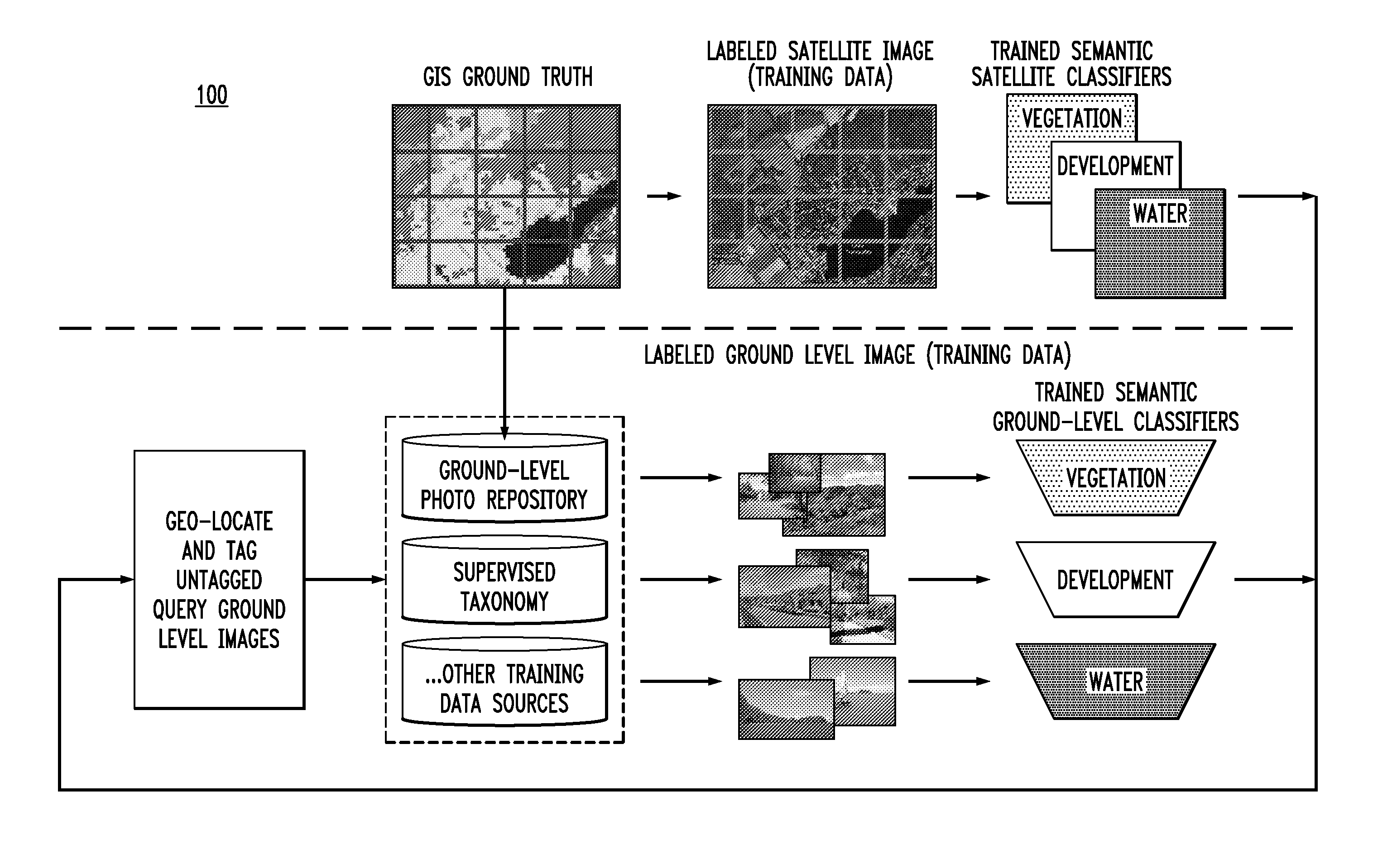
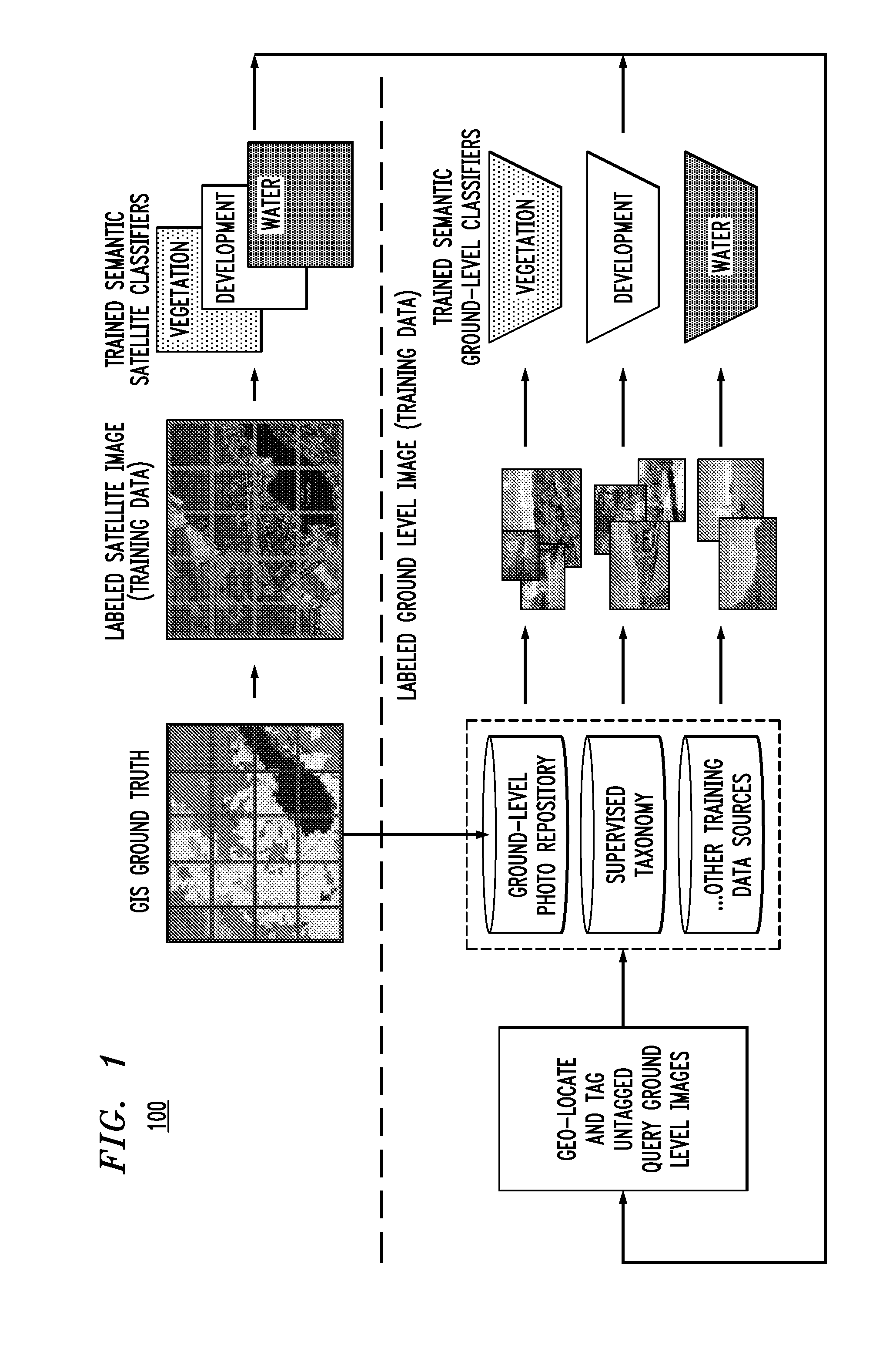
[0020]Digital elevation maps (DEMs) are an essential resource for geolocating images that have been acquired in remote regions where few distinguishing characteristics present themselves. In ground-level imagery, DEM data corresponds to the ridges and valleys in the terrain. These features are robust against illumination and seasonal changes, which makes them temporally independent: an ideal characteristic for most geolocating features, especially in remote regions. Efficiently matching ground-level photos to DEM data, however, remains an open research problem. F. Stein et al., “Map-Based Localization Using the Panoramic Horizon,” IEEE Transactions on Robotics and Automation, vol. 11, no. 6, pgs. 892-896 (December 1995) (hereinafter “Stein”), the contents of which are incorporated by reference herein, proposes a system which is able to localize a panoramic horizon against a DEM in approximately a minute. Stein presented only one example of localization, and their map region was only...


PUM


Abstract

Techniques for generating cross-modality semantic classifiers and using those cross-modality semantic classifiers for ground level photo geo-location using digital elevation are provided. In one aspect, a method for generating cross-modality semantic classifiers is provided. The method includes the steps of: (a) using Geographic Information Service (GIS) data to label satellite images; (b) using the satellite images labeled with the GIS data as training data to generate semantic classifiers for a satellite modality; (c) using the GIS data to label Global Positioning System (GPS) tagged ground level photos; (d) using the GPS tagged ground level photos labeled with the GIS data as training data to generate semantic classifiers for a ground level photo modality, wherein the semantic classifiers for the satellite modality and the ground level photo modality are the cross-modality semantic classifiers.

Description

CROSS-REFERENCE TO RELATED APPLICATION(S)[0001]This application is a continuation of U.S. application Ser. No. 13 / 744,688 filed on Jan. 18, 2013, the disclosure of which is incorporated by reference herein.FIELD OF THE INVENTION[0002]The present invention relates to data analysis and mining and more particularly, to techniques for generating cross-modality semantic classifiers and using those cross-modality semantic classifiers for ground level photo geo-location using digital elevation maps augmented with satellite imagery.BACKGROUND OF THE INVENTION[0003]Current photo geolocation processes permit geolocation in urban and well-developed areas where many unique landmarks exist and a dense amount of photographs are taken (by tourists and residents). For example, Google Goggles, available from Google Inc., allows a user to obtain information about a famous landmark using a search based on a photograph of the landmark. For instance, the user can take a photograph of the Statue of Liber...

Claims


Application Information

Patent Timeline
IPC IPC(8): G06K9/62
CPCG06K9/6256G06V20/188G06F18/214
Inventor CAO, LIANGLIANGCODELLA, NOEL C.F.HUA, GANGSMITH, JOHN R.
Owner IBM CORP
Why Eureka
Try Eureka