Method of and system for assisting a computer aided dispatch center operator with dispatching and/or locating public safety personnel

a computer aided dispatch center and computer aided technology, applied in traffic control systems, navigation instruments, instruments, etc., can solve problems such as affecting the determination of an effective response strategy to an incident, affecting the accuracy of location and time information, and affecting the accuracy of dispatching and/or locating public safety personnel

Active Publication Date: 2015-04-09
MOTOROLA SOLUTIONS INC
View PDF7 Cites 8 Cited by
  • Summary
  • Abstract
  • Description
  • Claims
  • Application Information

AI Technical Summary

Problems solved by technology

However, this location and time information may not accurately reflect the true current location of the PS device.
However, in reality, the displayed last location is only accurate as of the last time that the GPS signal was received.
Lack of true, up-to-date location information will eventually cause the CAD operator to lose confidence in the reliability and accuracy of the displayed last location and, as a result, will slow the determination of an effective response strategy to the incident and/or will slow any requested assist...

Method used


Image

  • Method of and system for assisting a computer aided dispatch center operator with dispatching and/or locating public safety personnel
  • Method of and system for assisting a computer aided dispatch center operator with dispatching and/or locating public safety personnel
  • Method of and system for assisting a computer aided dispatch center operator with dispatching and/or locating public safety personnel

Examples


Embodiment Construction

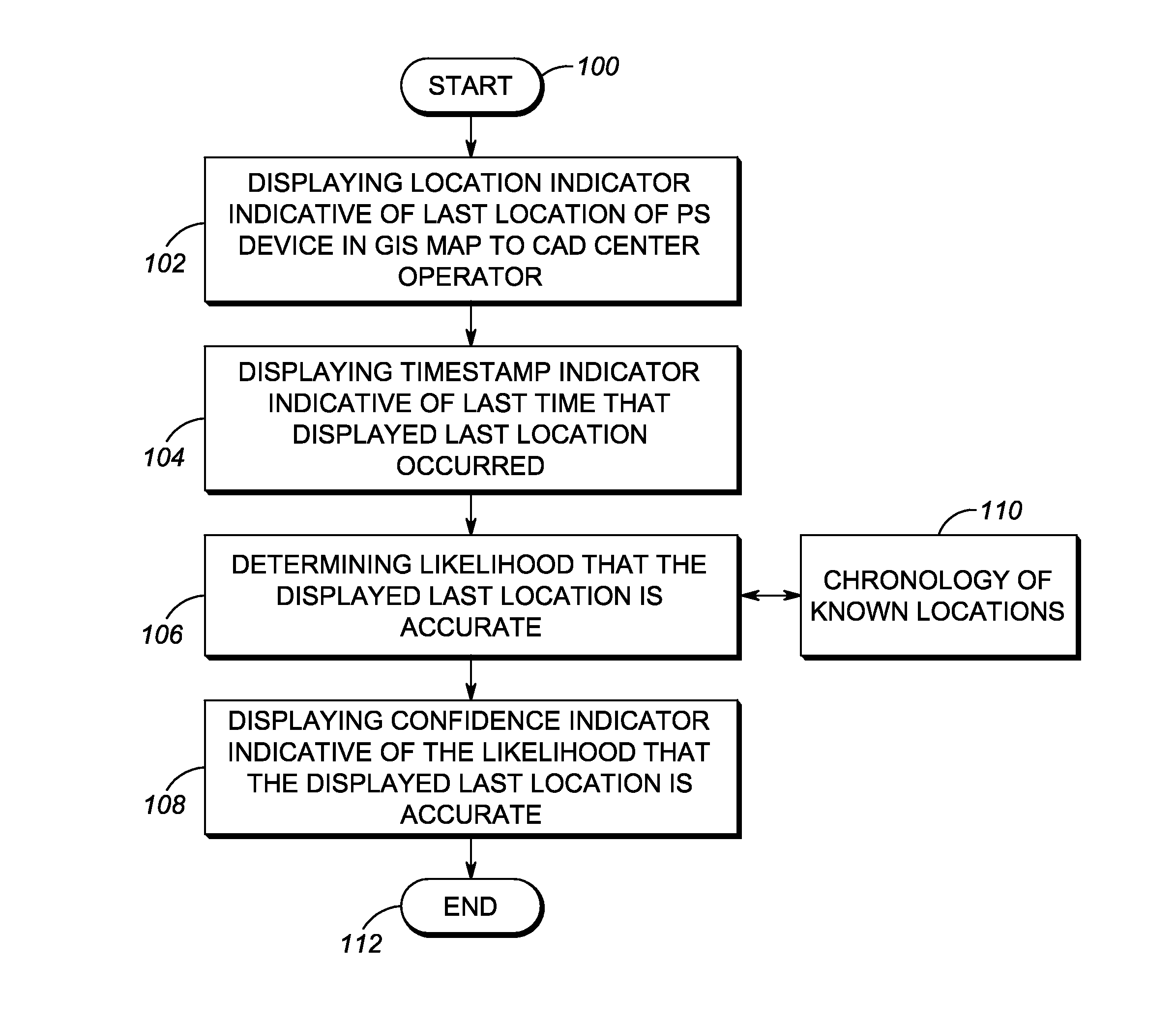
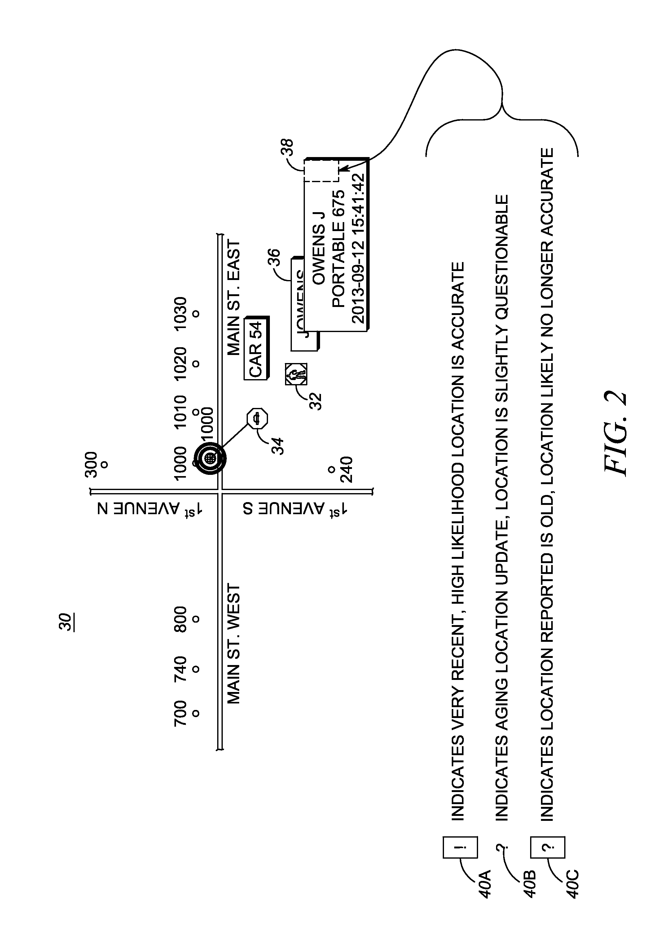
[0012]One aspect of this disclosure relates to a method of assisting an operator at a computer aided dispatch (CAD) center of a public safety (PS) network with field dispatching and / or locating at least one PS person operating a mobile PS device, e.g., a handheld land mobile radio and / or a vehicular radio, having a global positioning satellite (GPS) sensor. The method is performed by visually displaying a location indicator indicative of a last location of the PS device on a geographic information system (GIS) map to the operator at the CAD center based on a GPS signal received from the GPS sensor on the PS device, and by visually displaying on the map a timestamp indicator indicative of a last time that the GPS signal was received for the displayed last location. The method is further performed by determining a likelihood or probability that the displayed last location of the PS device on the map is accurate, and by visually displaying on the map, typically in response to a manual ...


PUM


Abstract

A computer aided dispatch (CAD) center operator can view a displayed location indicator indicative of a last location of a public safety (PS) device on a geographic information system (GIS) map, together with a displayed confidence indicator indicative of the likelihood that the displayed last location of the PS device is accurate, for use in dispatching a PS person to an incident scene, or locating the PS person.

Description

FIELD OF THE DISCLOSURE[0001]The present disclosure relates generally to a method of, and a system for, assisting an operator at a computer aided dispatch (CAD) center of a public safety (PS) network with field dispatching and / or locating a PS person operating a mobile PS device, e.g., a handheld land mobile radio and / or a vehicular radio, by visually displaying on a geographic information system (GIS) map to the operator a confidence indicator indicative of the likelihood that a last location of the PS device displayed on the map is accurate.BACKGROUND[0002]In an emergency or like incident, public safety (PS) personnel, such as police officers, firefighters, paramedics, emergency medical service technicians, disaster relief workers, military rescue personnel, and like first responders, are typically dispatched by an operator at a computer aided dispatch (CAD) center to an incident scene to respond to remedy the emergency. These PS personnel typically utilize and operate PS communic...

Claims


Application Information

Patent Timeline
IPC IPC(8): G01S19/14
CPCG01S19/14G01S19/39G06Q10/0631G06Q90/205G01S19/17G01S5/0244
Inventor PACHOLSKI, DANIEL J.METKE, ANTHONY R.
Owner MOTOROLA SOLUTIONS INC
Why Eureka
Try Eureka