Generating georeference information for aerial images

Active Publication Date: 2017-03-23
SKYCATCH
View PDF0 Cites 66 Cited by
  • Summary
  • Abstract
  • Description
  • Claims
  • Application Information

AI Technical Summary

Benefits of technology

[0014]Moreover, the disclosed systems and methods provide accurate georeference information. For instance, utilizing one or more of the disclosed systems and methods, users can correlate aerial image data to real-world geographic coordinates within centimeters of accuracy, despite the fact that aerial images were not origina

Problems solved by technology

Although systems that utilize markers permit users to relate digital image data to known ground control points with remarkable accuracy, such systems introduce their own problems.
Because placing the markers may require specialized expertise and surveying equipment, this process can result in excessive costs in both time and expense.
Moreover, in some instances, users may forget to place markers (or may inaccurately place markers) when capturing aerial image data.
Such situations may result in additional wasted time and expense, as users are required to recapture image data or proceed without ac

Method used


Image

  • Generating georeference information for aerial images
  • Generating georeference information for aerial images
  • Generating georeference information for aerial images

Examples


Example

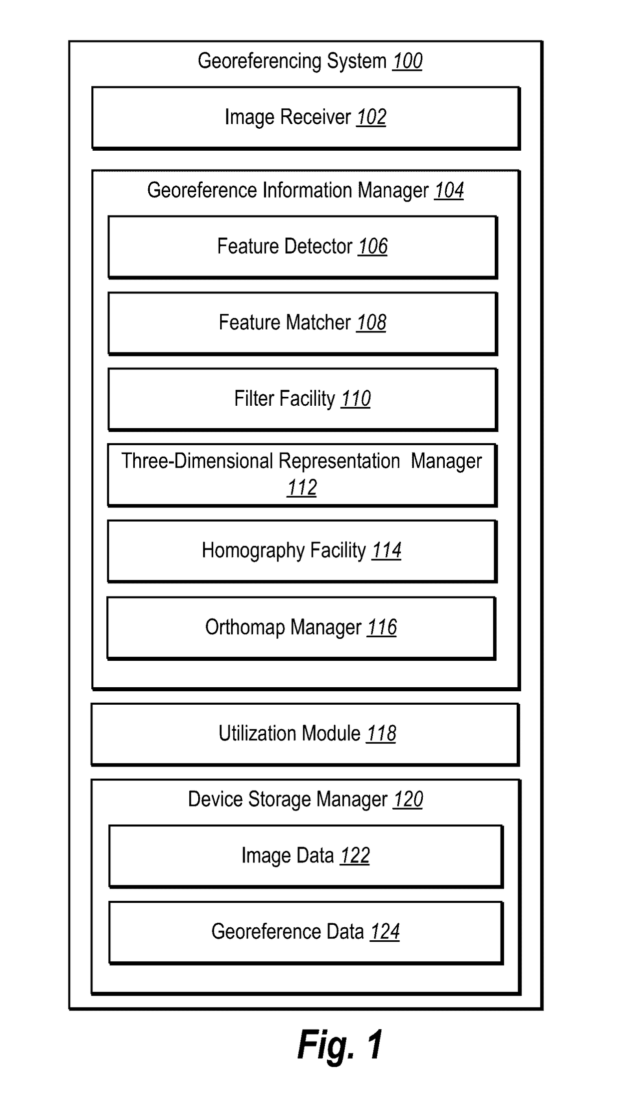
[0036]One or more embodiments of the present disclosure include an image georeferencing system that generates georeference information related to one or more aerial images. In particular, in one or more embodiments the georeferencing system utilizes existing aerial images captured with georeference information (e.g., ground control points) to generate georeference information for aerial images captured without such information. More specifically, the image georeferencing system utilizes various methods to compare features of existing aerial images with georeference information to the features of new aerial images captured without georeference information to generate georeference information related to the new aerial images.

[0037]For example, in one or more embodiments the image georeferencing system accesses a set of aerial images of a site showing known ground control points and builds an unreferenced three-dimensional representation based on the set of aerial images. The image geo...


PUM


Abstract

Systems and methods are disclosed for generating georeference information with respect to aerial images. In particular, in one or more embodiments, systems and methods generate georeference information relating to aerial images captured without ground control points based on existing aerial images. For example, systems and methods can access a new set of aerial images without ground control points and utilize existing aerial images containing ground control points to generate a georeferenced representation corresponding to the features of the new set of aerial images. Similarly, systems and methods can access a new image without ground control points and utilize an existing georeferenced orthomap to produce a georeferenced orthomap corresponding to the features of the new image. One or more embodiments of the disclosed systems and methods permit users to obtain georeference information related to new images without the need to place ground control points or collect additional georeference information.

Description

BACKGROUND[0001]1. Technical Field[0002]One or more embodiments of the present disclosure relate generally to georeference information. More specifically, one or more embodiments of the present disclosure relate to systems and methods for generating georeference information for aerial images.[0003]2. Background and Relevant Art[0004]Recent years have seen a rapid increase in the use of digital aerial images in various applications. In particular, given the recent proliferation of unmanned aerial vehicles (UAVs) in commercial and industrial applications, digital aerial photography has become more common in individual and business environments. For instance, individuals now commonly utilize UAVs to capture digital aerial images of homes, places of interest, or even recreational activities.[0005]In many applications, however, individuals and businesses find it imperative to tie digital aerial image data to precise geographic locations. For example, in a construction application, a desi...

Claims


Application Information

Patent Timeline
IPC IPC(8): G06T7/00G06K9/00G06T17/05G06K9/46
CPCG06T7/0044G06K9/4671G06K9/0063G06K9/4609G06T2207/10028G06T2207/10032G06T2207/20076G06T2207/20024G06T2207/30181G06T17/05G06T7/74G01C11/06G06T2207/30184G06T7/579G06V20/176G06V10/443G06V10/462G01C21/26G06T7/337G06T7/50
Inventor BARAJAS HERNANDEZ, MANLIO FRANCISCOMORALES, LEONARDO FELIPE ROMOCHEN, DAVIDLI, SIDA
Owner SKYCATCH
Why Eureka
Try Eureka