Three-dimensional map display system

a display system and three-dimensional map technology, applied in maps/plans/charts, instruments, computing, etc., can solve the problems of extremely high processing load of display, huge number of three-dimensional models, and high load of drawing processing of three-dimensional maps

Inactive Publication Date: 2017-10-26
GEO TECHN LAB
View PDF8 Cites 2 Cited by
  • Summary
  • Abstract
  • Description
  • Claims
  • Application Information

AI Technical Summary

Problems solved by technology

Here, the three-dimensional map includes a large number of features, and since a ground surface is represented by polygons, the number of the three-dimensional models becomes huge, and a load of drawing processing of the thre...

Method used


Image

  • Three-dimensional map display system
  • Three-dimensional map display system
  • Three-dimensional map display system

Examples


embodiment 1

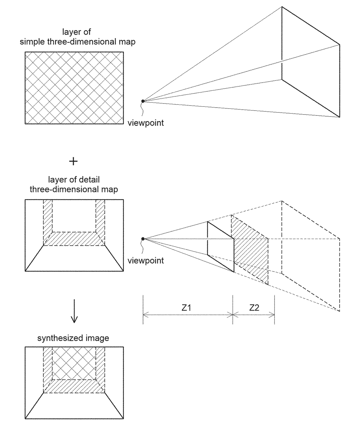
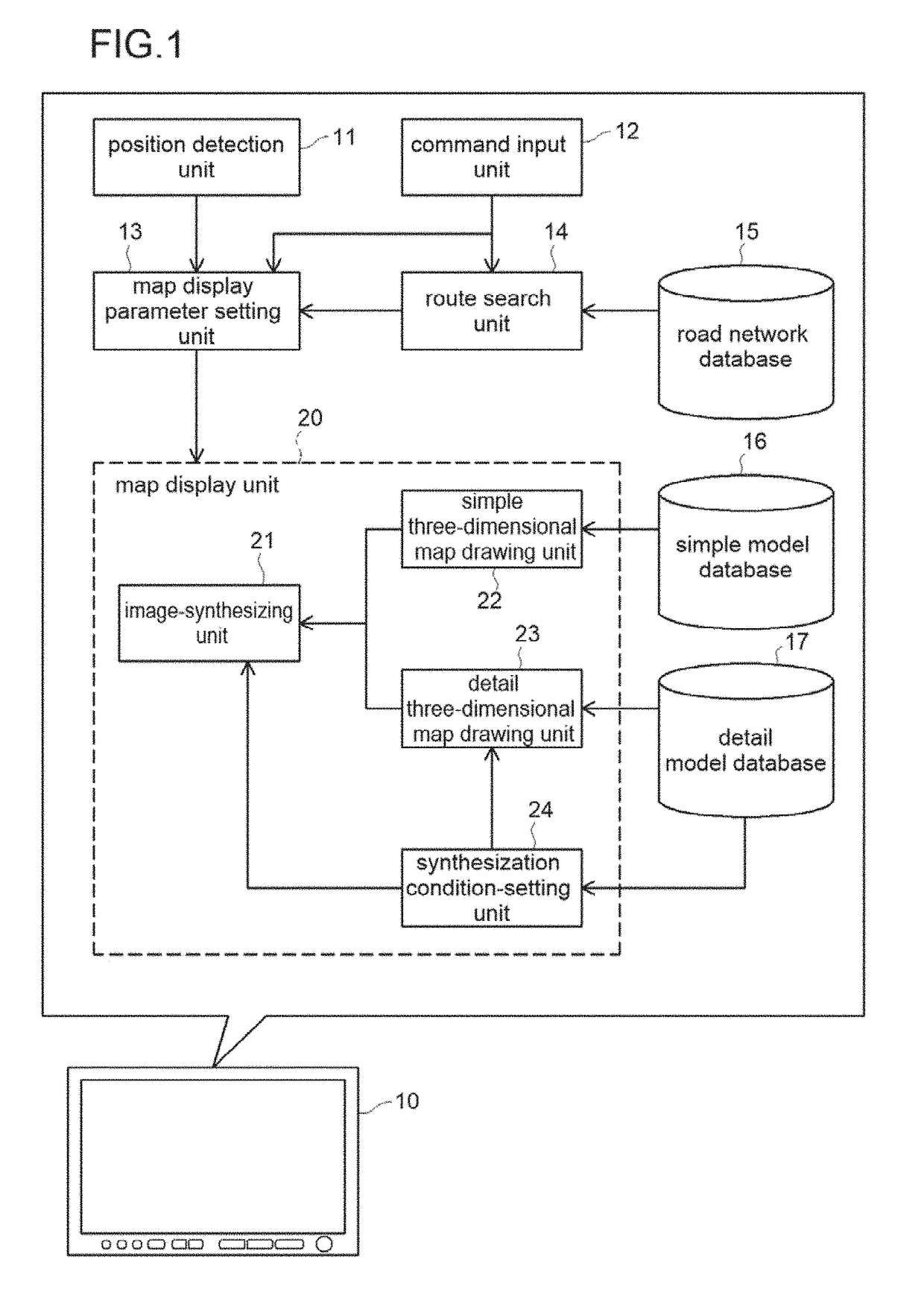
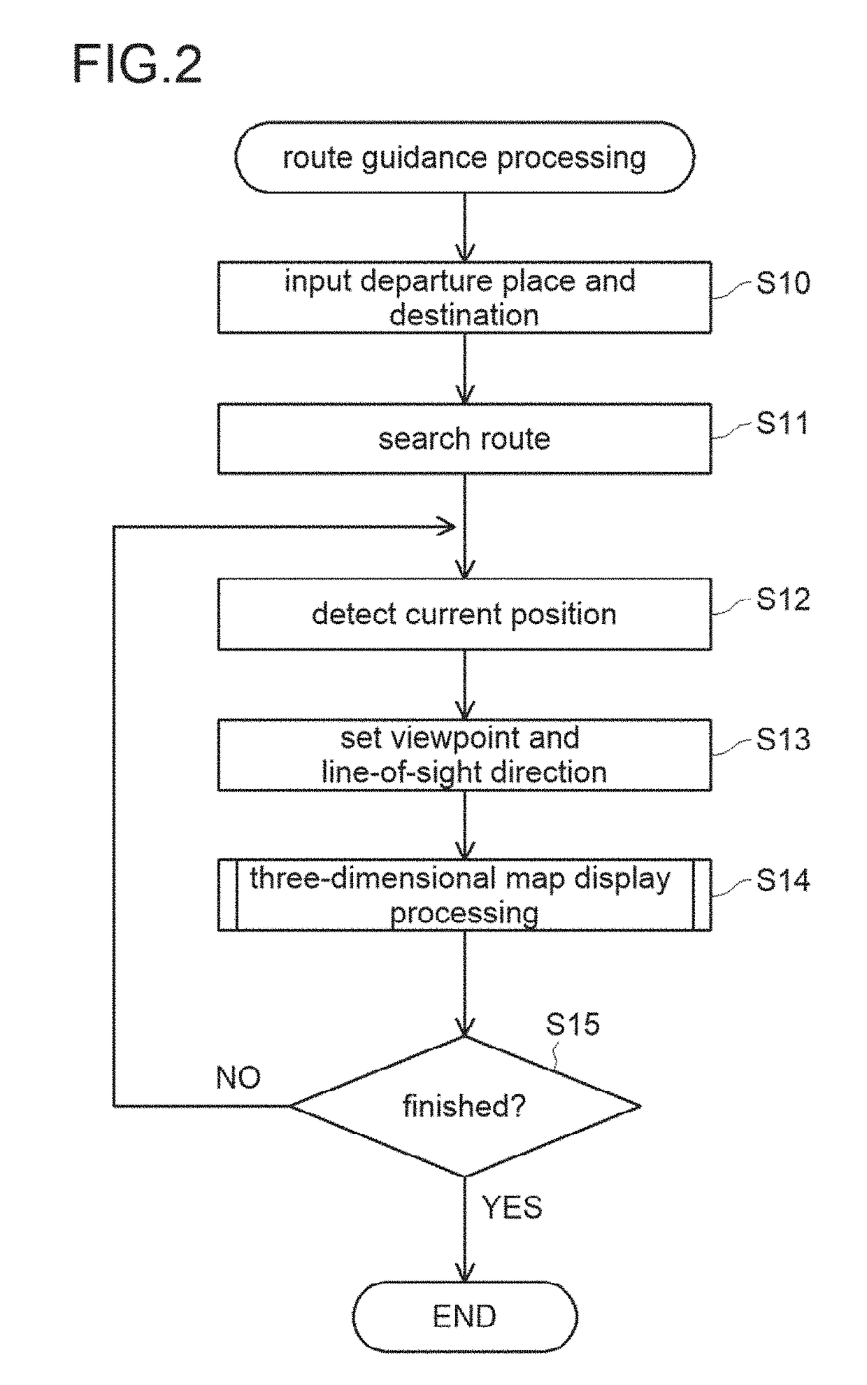
[0045]Regarding the present invention, in a navigation device, an embodiment configured as a three-dimensional map display system displaying a three-dimensional map on a display during route guidance will be described. In this embodiment, a vehicle-mount navigation device will be described as an example, but the three-dimensional map display system of the present invention can be also configured as a portable navigation device using a mobile terminal such as a smart phone, a mobile phone, and a tablet terminal in addition to that. Moreover, it can be configured as a system for displaying the three-dimensional map on a display of a computer or the like statically or dynamically regardless of route search or route guidance.

[0046]Moreover, in this embodiment, a system operating in a stand-alone manner is exemplified, but it may be configured as a system storing each database or the like illustrated in the figure in a server and connecting the server and the navigation device via a netw...


PUM


Abstract

A three-dimensional map is displayed over the whole display area with a relatively light load using a detailed model database including feature data with a higher accuracy of details and a simple model database including feature data with a lower accuracy of details. A first range is set within a predetermined distance from a view point in a line-of-sight direction as a detailed model drawing range in which a detailed three-dimensional map is drawn using the detailed model. A second range in which a simple three-dimensional map is drawn using the simple model is set to include a range where the detailed three-dimensional map is not drawn. The detailed three-dimensional map and the simple three-dimensional map are both displayed by superimposing the detailed three-dimensional map in front of the simple three-dimensional map.

Description

CLAIM OF PRIORITY[0001]This application is a Continuation of International Patent Application No. PCT / JP2015 / 085754, filed on Dec. 22, 2015, which claims priority to Japanese Patent Application No. 2015-008523, filed on Jan. 20, 2015, each of which is hereby incorporated by reference.BACKGROUND OF THE INVENTION1. Field of the Invention[0002]The present invention relates to a three-dimensional map display system which displays a three-dimensional map by combining a plurality of map models with different accuracy of features.2. Description of the Related Art[0003]A three-dimensional map representing features such as a building in a three-dimensional manner is often used as an electronic map used in a navigation device, a computer screen or the like. The three-dimensional map is generally displayed by drawing a three-dimensional model in a three-dimensional manner by means of perspective projection or the like.[0004]Here, the three-dimensional map includes a large number of features, a...

Claims


Application Information

Patent Timeline
IPC IPC(8): G06T15/00G06T17/05G09B29/00G09B29/10
CPCG06T15/00G09B29/10G09B29/00G06T17/05
Inventor UCHINOUMI, MASASHITESHIMA, EIJIFUKUSHIMA, YUKI
Owner GEO TECHN LAB
Why Eureka
Try Eureka