Check patentability & draft patents in minutes with Patsnap Eureka AI!

Systems and methods for dynamically determining activity levels in a selected geographical region

a technology of dynamic determination and activity level, applied in the field of identifying the level of human social activity in a region, can solve the problems of difficult to determine which restaurants, retail shops, or nightlife locations are popular with tourists and travelers, and it is difficult to determine which areas are more active,

Active Publication Date: 2020-01-09
MASTERCARD INT INC
View PDF3 Cites 5 Cited by
  • Summary
  • Abstract
  • Description
  • Claims
  • Application Information

AI Technical Summary

Benefits of technology

The patent describes an active locations (AL) computing device that can receive user selection of a geographical region and retrieve data related to the region, including transaction data, environmental data, merchant data, and social media data. The device can then determine the activity levels of the region based on this data and convert it into a user-interactive heat map. The heat map can be applied a user-controlled filter and transmitted to a user computing device for display. The technical effect of this patent is to provide a way for users to easily identify active locations within a geographical region by using a device that combines data from various sources, such as transaction data, environmental data, merchant data, and social media data.

Problems solved by technology

When visiting a new place, tourists and travelers often have difficulty determining which restaurants, retail shops, or nightlife locations (e.g., bars, clubs) are the most popular.
Even for a resident or a frequent visitor to an area, it may be difficult to determine which areas are more active.
Planning for visits according to these preferences can be difficult, and generally requires gathering a wide variety of data from a multitude of sources and incorporating many different factors.
Combining this information to predict whether an area is active or busy requires a sophisticated analysis, which is very difficult if not impossible to conduct in a timely manner prior to or during travel to the area.
Currently, people generally rely on word-of-mouth or personal experience to identify popular locations, which may not be reliable.

Method used


Image

  • Systems and methods for dynamically determining activity levels in a selected geographical region
  • Systems and methods for dynamically determining activity levels in a selected geographical region
  • Systems and methods for dynamically determining activity levels in a selected geographical region

Examples


Embodiment Construction

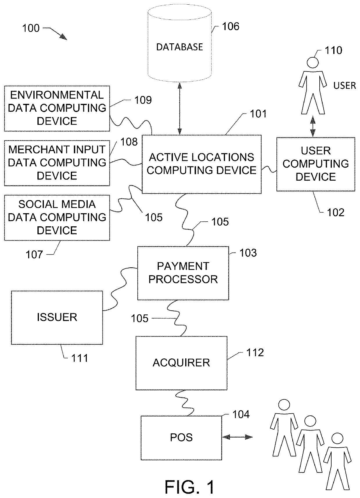
[0016]The system and methods described herein enable a user to identify active or “popular” locations (e.g., bars, restaurants, stores, entertainment areas, etc.) in a geographical region. In particular, the system collects and converts activity information using environmental data, transaction data, merchant input data, and user-generated social media data into a visually accessible format to facilitate travel and entertainment planning.

[0017]In an example embodiment, an active locations computer system includes an active locations (AL) computing device including at least one processor in communication with at least one memory device. The AL computing device is configured to receive and process transaction data and other external data sets including environmental data, merchant input data, and social media data. Transaction data may include recent or historical data associated with payment transactions, initiated by a customer at a merchant location. Environmental data may include ...


PUM


Abstract

An active locations (AL) computing device is described herein. The AL computing device is programmed to receive, from a user computing device, a selection of a geographical region. The AL computing device may retrieve transaction data from a payment processing network, environmental data representing environmental conditions at the selected geographical region, merchant data representing characteristics of one or more merchants located within the selected geographical region, social media data including events occurring within the selected geographical region, and historical data. The AL computing device is further programmed to determine activity levels for the selected geographical region based on one or more of the transaction data, environmental data, merchant data, social media data, and historical data. The AL computing device may convert the determined activity levels into an interactive heat map, apply a filter to the heat map, and transmit the heat map to the user computing device.

Description

BACKGROUND[0001]This disclosure relates generally to identifying a level of human social activity in a region and more particularly, to a network-based system and method for collecting and converting activity data in the region into an accessible format and displaying it in a user interface system having filter controls.[0002]When visiting a new place, tourists and travelers often have difficulty determining which restaurants, retail shops, or nightlife locations (e.g., bars, clubs) are the most popular. Even for a resident or a frequent visitor to an area, it may be difficult to determine which areas are more active. In some cases, people may wish to avoid extremely busy areas and plan travel times for when a desired location is less busy. In other cases, people may wish to locate and visit the active areas.[0003]Planning for visits according to these preferences can be difficult, and generally requires gathering a wide variety of data from a multitude of sources and incorporating ...

Claims


Application Information

Patent Timeline
IPC IPC(8): G06Q30/06G06Q50/00G06F17/30
CPCG06Q50/01G06F16/29G06Q30/0625H04W4/021H04W4/029H04W4/21H04W4/23H04L67/306G06Q30/0201G06Q50/10
Inventor YELDHAM, KEITH J.
Owner MASTERCARD INT INC
Features
  • R&D
  • Intellectual Property
  • Life Sciences
  • Materials
  • Tech Scout
  • Unparalleled Data Quality
  • Higher Quality Content
  • 60% Fewer Hallucinations
Learn More