System and method for automatically collecting images of objects at geographic locations and displaying same in online directories

a technology of automatic collection and geographic location, applied in the direction of television system, navigation instrument, instrument, etc., can solve the problems of lack of listings, limited value of aerial or rooftop views, and lack of an automated system and method

Active Publication Date: 2006-12-26
A9 COM INC
View PDF5 Cites 115 Cited by
  • Summary
  • Abstract
  • Description
  • Claims
  • Application Information

AI Technical Summary

Benefits of technology

[0003]The present invention provides methods and systems whereby online directories, such as online Yellow Pages, may feature listings with an associated actual image of the business taken by a camera. Thus, a user accessing an online Yellow Page directory prepared using the present invention can visually appreciate the business, i.e., its building, and also perhaps its surrounding area. From the businesses' point of view, an online Yellow Page directory that uses the present invention provides value-added media through which the businesses can visually appeal to their potential customers to hopefully attract more business.
[0009]Once the address-correlated images are prepared, they are loaded to a server system in communication with a client system for supporting an online directory, wherein the address in each listing is correlated with an image of an object taken at the geographic location of the address. In one embodiment, the server system receives selection criteria for at least one listing from a client system. The server system displays on the client system at least one listing (e.g., business name, address, phone number, etc.) meeting the selection criteria. The server system then displays on the client system an image of an object taken at the address of the at least one listing meeting the selection criteria. An image may be automatically displayed together with the listing itself. In one embodiment, the user may also be permitted to request a zoom-in view, a zoom-out view, a scrolled-to-the right view, or a scrolled-to-the-left view of the displayed image, so as to appreciate, for example, the neighborhood view of the area surrounding the listing of interest. Also, the user may be further permitted to obtain a 360-degree view in some selected locations, such as at intersections, depending on images available in the system. For example, the user may be permitted to click and drag a cursor on the displayed image itself to shift the view point in any direction. Accordingly, an online directory using the present invention may permit the user to visually appreciate not only the images of various listings (e.g., businesses) but also the neighborhood surrounding these listings.

Problems solved by technology

Current online directories, however, do not provide listings that can be displayed with an image of the physical location of the business featured in the listing.
While some aerial or rooftop images are available online in correlation with addresses, such aerial or rooftop views are of limited value because they do not show, for example, business buildings in the manner actually perceived by customers (i.e., at the ground level).
More particularly, what is lacking is an automated system and method for collecting and displaying images of objects at geographic locations, such as business storefronts, in online directories.

Method used


Image

  • System and method for automatically collecting images of objects at geographic locations and displaying same in online directories
  • System and method for automatically collecting images of objects at geographic locations and displaying same in online directories
  • System and method for automatically collecting images of objects at geographic locations and displaying same in online directories

Examples


Embodiment Construction

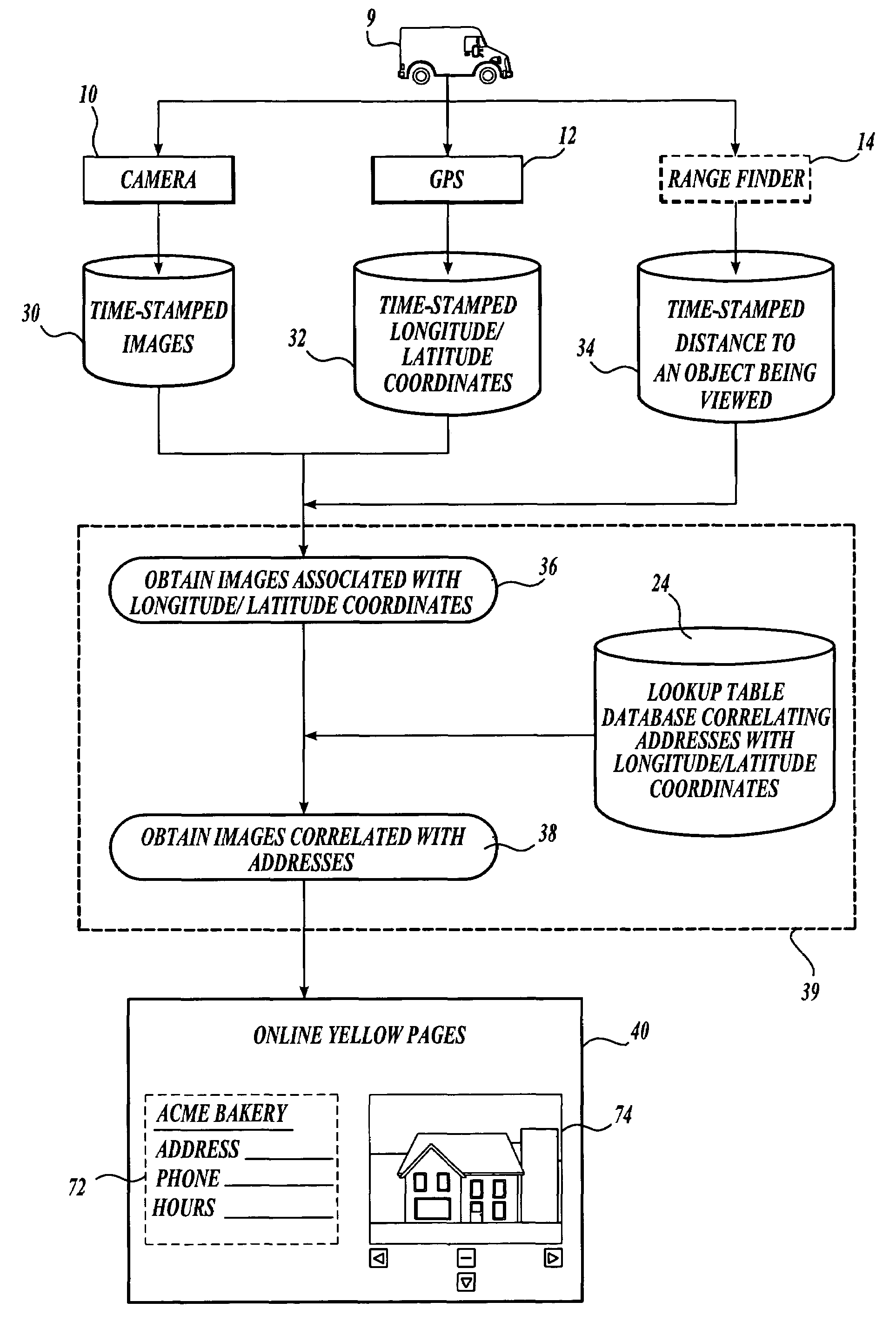
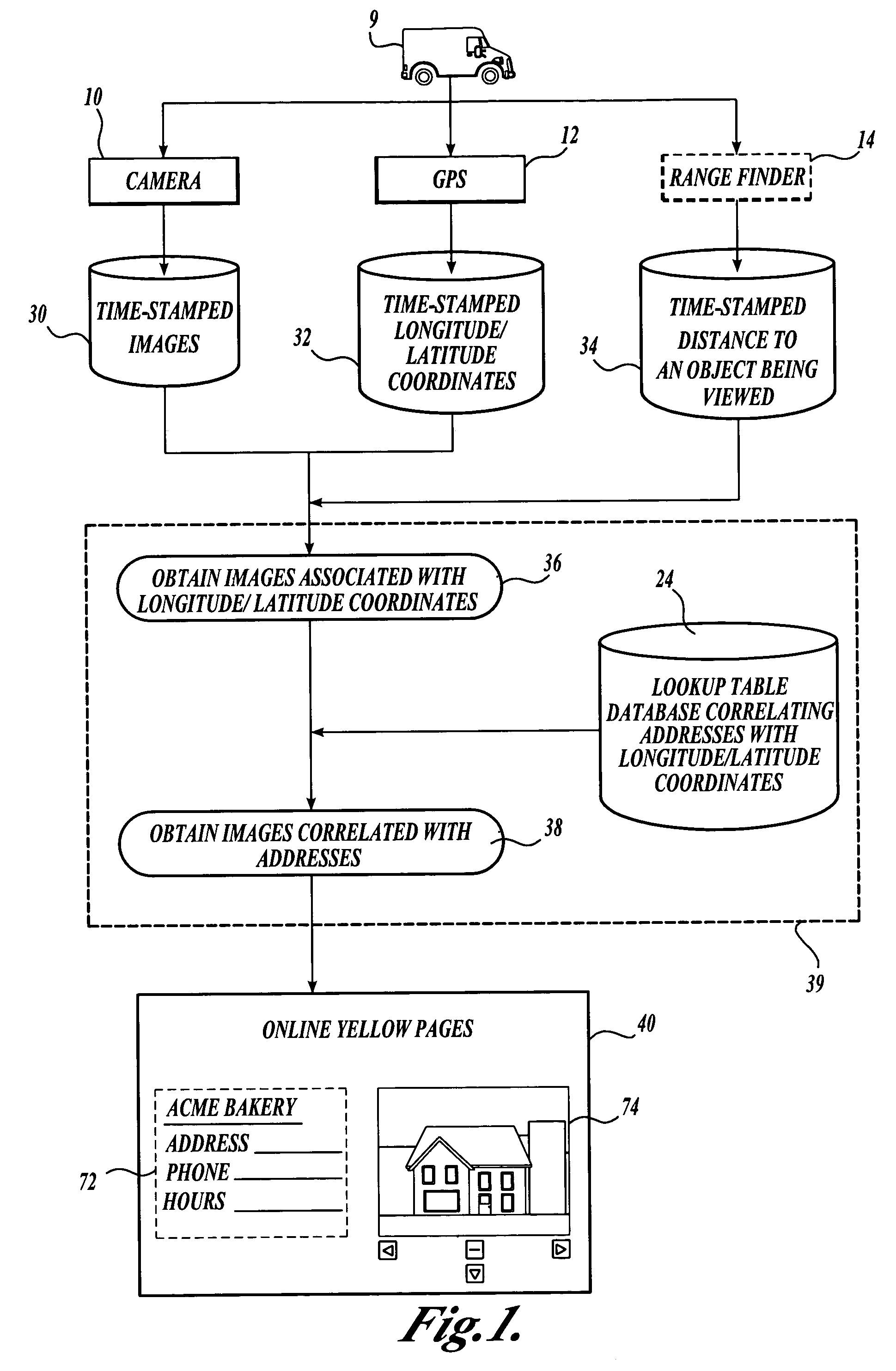
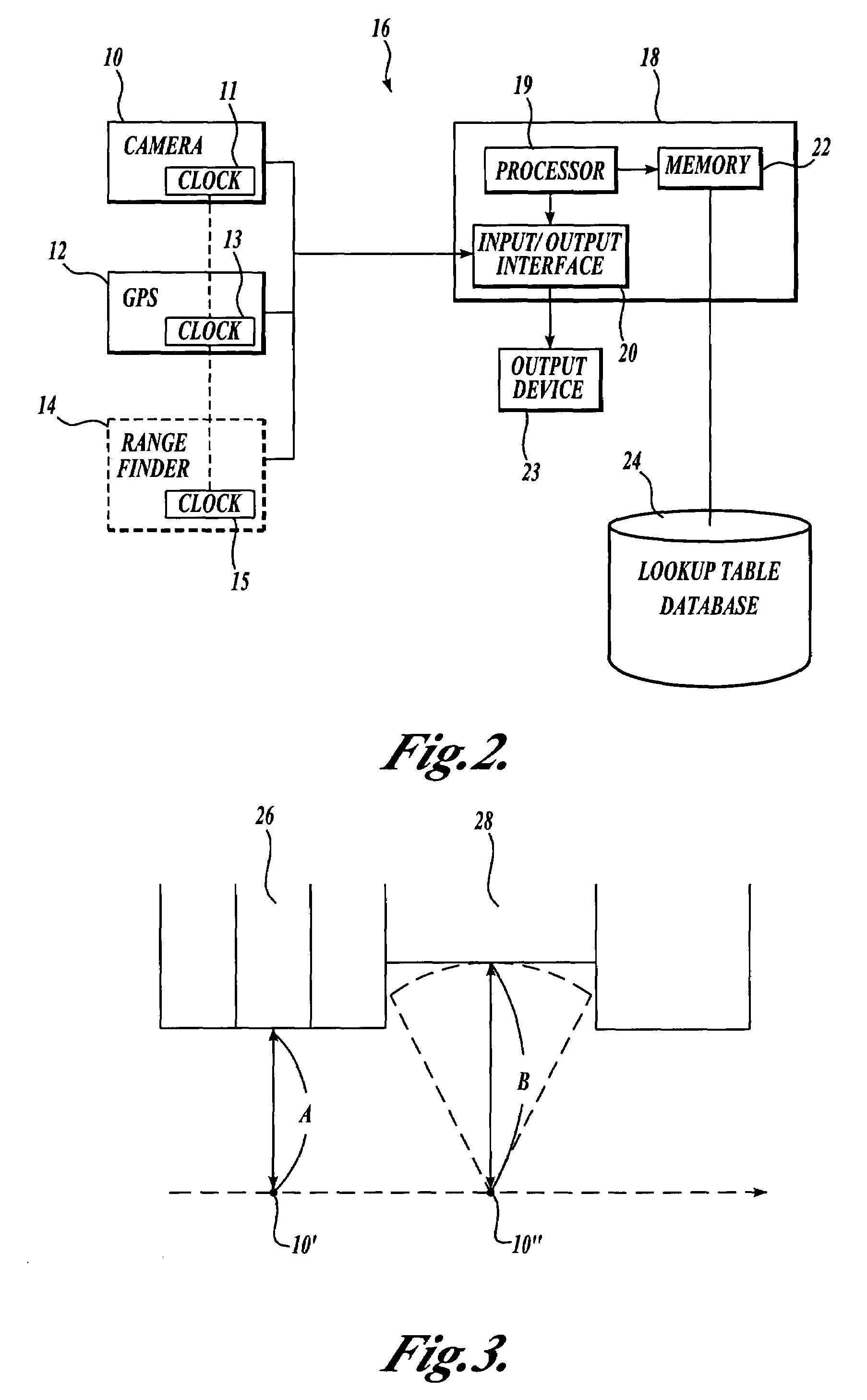
[0017]The present invention is directed to a system and method for collecting images of objects (including, without limitation, buildings and store fronts) obtained at different geographic locations. The images may be displayed in association with corresponding listings in online directories. The following detailed description provides several exemplary implementations of the invention. Although specific system configurations and flow diagrams are illustrated, it should be understood that the examples provided are not exhaustive and do not limit the invention to the precise forms disclosed. Persons having ordinary skill in the field of digital data processing will recognize that the computer components and arrangements described herein may be interchangeable with other components and arrangements, and that the process steps described herein may be interchangeable with other steps or their combinations, and still achieve the benefits and advantages of the present invention.

[0018]It s...


PUM


Abstract

A method and system are provided for collecting images of objects at geographic locations for publication in an online directory, such as online Yellow Pages. A camera and a GPS receiver, both receiving time information from a synchronized clock, are mounted on a vehicle. Time-stamped images captured by the camera and time-stamped geographic locations (e.g., longitude and latitude coordinates) determined by the GPS receiver are recorded. Each image is then associated with a geographic location based on corresponding respective time-stamps. Thereafter, each image is correlated with a street addresses based on each image's associated geographic location, for example by referring to a lookup table that correlates addresses with geographic coordinates. The address-correlated images may then be used in an online directory, where each listing (e.g., business) can be displayed with an image of an object (e.g., store front) taken at the address in the listing.

Description

FIELD OF THE INVENTION[0001]The present invention is related to production of online directories and, more specifically, to online directories, such as Yellow Pages, at which a user can view images.BACKGROUND OF THE INVENTION[0002]Various online directories, such as online Yellow Pages, are available. Typically, when searching an online business directory, a user is prompted to enter selection criteria such as the general geographic location (e.g., state and city) and the type or category of business (e.g., restaurant) that the user is looking for, or perhaps the name of the business itself, if known. In response, listings for each of the businesses that meet the user's selection criteria are displayed. Each listing typically identifies the name, address, and phone number of the listed business. Further, each listing may be associated with icons that the user may click to obtain further information about the business, such as the map of an area around the business and driving direct...

Claims


Application Information

Patent Timeline
Patent Type & Authority Patents(United States)
IPC IPC(8): G01C21/26G01C21/00G06F17/30G01S19/48G06Q30/00G09B29/00G09B29/10
CPCG06F17/30241G06Q30/018G06Q30/02G06Q30/0244G09B29/006G09B29/106G06F16/29
Inventor DORFMAN, BARNABY M.MANBER, UDIGOLD, JONATHAN A.
Owner A9 COM INC
Why Eureka
Try Eureka