Crime risk assessment system

a risk assessment and information system technology, applied in surveying and navigation, navigation instruments, instruments, etc., can solve problems such as false sense of security, information that does not always present in a form, and information that does not always provide crime risk information

Active Publication Date: 2013-08-20
TRINKO DOMINIC +1
View PDF12 Cites 14 Cited by
  • Summary
  • Abstract
  • Description
  • Claims
  • Application Information

AI Technical Summary

Benefits of technology

[0007]The present invention provides a source of proxy data derived from actual images of an area, scored according to visual features that are correlated to crime. Such images may be obtained readily from services such as Google using services such as Street View™ and Panoramio™ and may be scored automatically by image processing software or manually using Internet systems such as Mechanical Turk™ which enlist individuals.
[0017]It is thus a feature of at least one embodiment of the invention to compensate for inaccuracy in the proxy process by increasing sampling density.
[0023]It is thus a feature of at least one embodiment of the invention to provide the ability to reveal the underlying basis for the proxy to the end-user.
[0025]It is thus a feature of at least one in body meant of the invention to provide an indication to the user of the basis for the crime risk data so as to improve confidence in the system.

Problems solved by technology

A traveler with a GPS system and an updated map, however, may have a false sense of security based on a knowledge of his or her location on the map but an ignorance about the safety of that location.
A potential barrier to providing crime risk information to travelers and the like is in obtaining accurate crime data.
While many municipalities by law must make such data available, the information is not always presented in a form that may be readily collected and disseminated to the public.

Method used


Image

  • Crime risk assessment system
  • Crime risk assessment system
  • Crime risk assessment system

Examples


Embodiment Construction

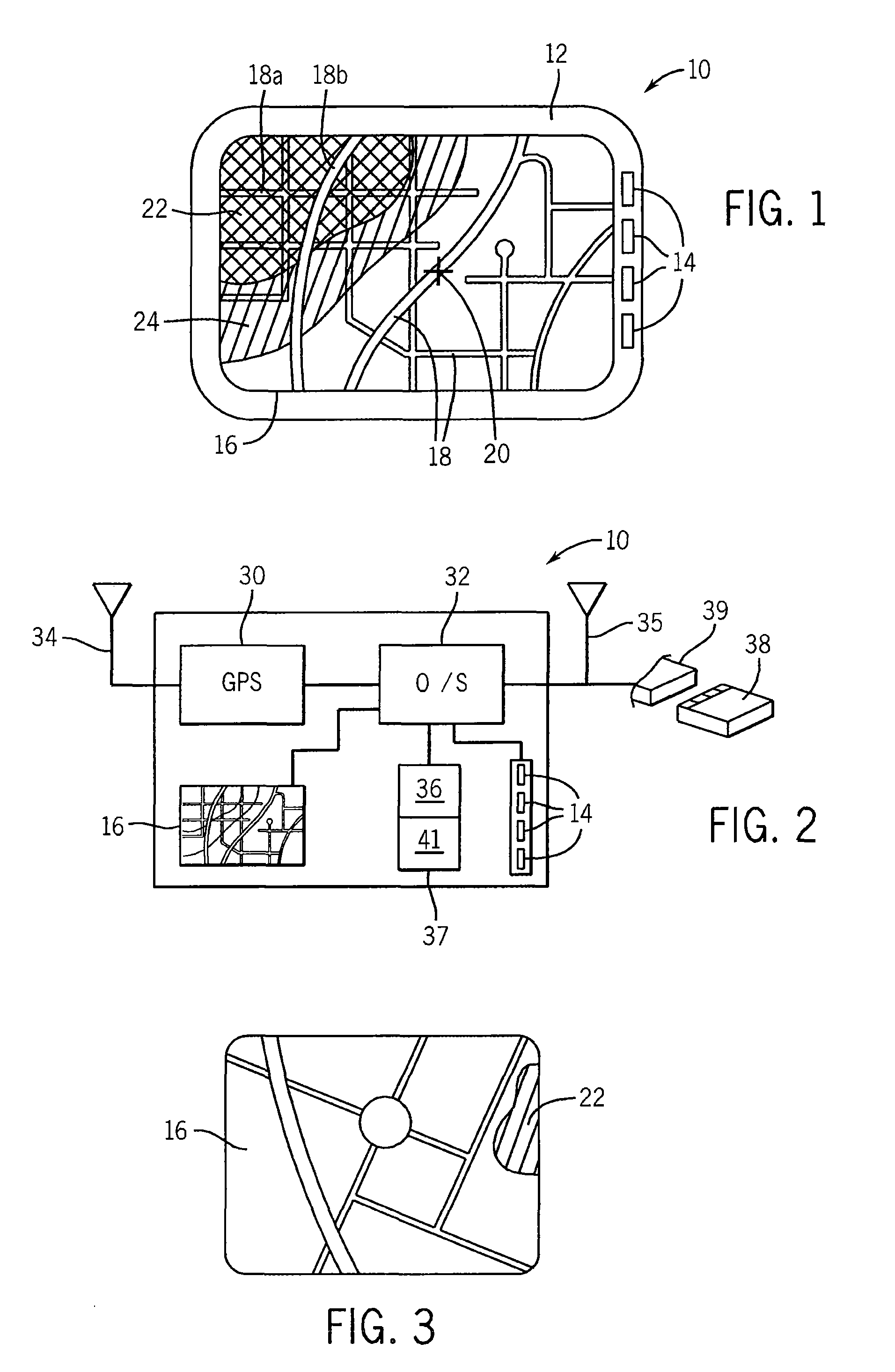
[0043]Referring now to FIG. 1, a GPS device of a type that may be mounted in a car or the like may provide a housing 12 supporting one or more user controllable buttons 14 on the side of a color graphic display 16. As is generally understood in the art, the display 16 may depict a map showing streets 18 and a cursor 20 showing the location of the vehicle. The orientation of the streets may change to show the direction of travel of the vehicle according to standard conventions, for example, the direction of travel being vertical on the display 16.

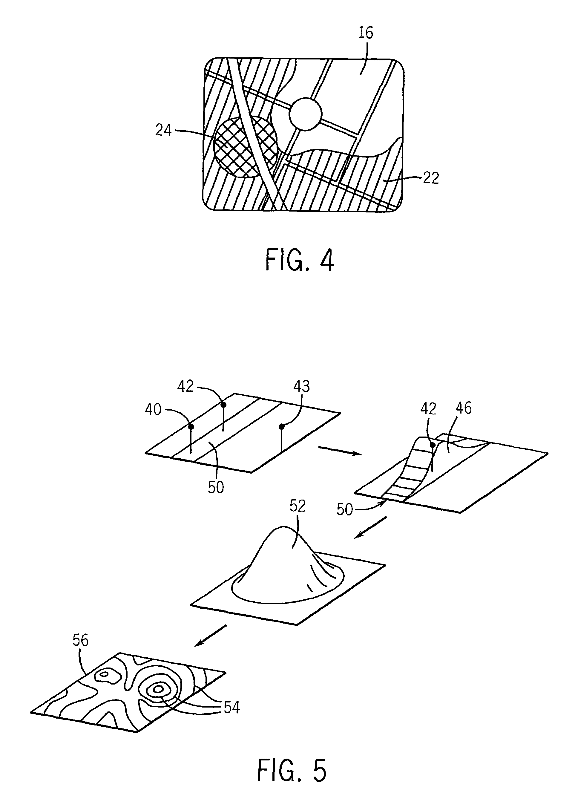
[0044]The present invention may further provide for a first and second zone of shading 22 and 24 superimposed on the map and depicting a measure of the crime in the vicinity of the cursor 20. The shading may be different brightnesses, colors, or highlighting, a density of points (either randomly placed or each indicating a crime), or simply boundary markings according to techniques well known in the art and may cover particular streets 18 (t...


PUM


Abstract

A method of providing crime risk data in the absence or partial absence of officially reported data uses a scoring system based on images of locations within particular regions where crime data is to be assessed. The collected crime data may be normalized to actual crime data were both exist to calibrate the proxy crime data derived from the images.

Description

CROSS REFERENCE TO RELATED APPLICATION[0001]This application claims the benefit of 61 / 328,786, filed Apr. 28, 2010, and is a continuation in part of U.S. patent application Ser. No. 12 / 597,425, filed Oct. 23, 2009, now U.S. Pat. No. 8,290,705 entitled “Mobile Navigation System with Graphic Crime-Risk Display”, both hereby incorporated by reference.BACKGROUND OF THE INVENTION[0002]The present invention relates to information systems for use by travelers and in particular to an information system which provides the user with an indication the crime risk of a particular location.[0003]GPS and other navigation systems for portable use may contain digital maps of specific areas and may superimpose a user's location determined by the GPS on a graphical representation of the map. While the maps used in GPS systems currently are relatively static, it is also known to provide an ability to download updated or new maps with the GPS system to keep the loaded map system current, to load new map...

Claims


Application Information

Patent Timeline
Patent Type & Authority Patents(United States)
IPC IPC(8): G01C21/00
CPCG01C21/3461G01C21/3697
Inventor TRINKO, DOMINICTRINKO, THOMAS
Owner TRINKO DOMINIC
Why Eureka
Try Eureka