Check patentability & draft patents in minutes with Patsnap Eureka AI!

Geofence prioritization

Active Publication Date: 2017-08-15
HCL TECH LTD
View PDF27 Cites 17 Cited by
  • Summary
  • Abstract
  • Description
  • Claims
  • Application Information

AI Technical Summary

Benefits of technology

This patent provides a method, computer system, and computer program product for prioritizing the transmission of geofences. The method involves querying a list of available geofences, retrieving historical data from data sources, analyzing the historical data to understand previous interactions between users and geofences, and creating a prioritized list of geofences based on the historical data. The system then transmits each geofence in order of rating up to a maximum number of allowable geofences. The technical effect of this patent is to improve the efficiency and accuracy of geofence transmissions by prioritizing the transmission of relevant geofences based on their historical interactions with users.

Problems solved by technology

Unfortunately, the platforms have limitations on the number of geofences that can be monitored.
Often this means returning only those geofences within the closest distance to the customer in combination with an expensive API call periodically to check if a big location change has occurred.

Method used


Image

  • Geofence prioritization
  • Geofence prioritization
  • Geofence prioritization

Examples


Embodiment Construction

Overview

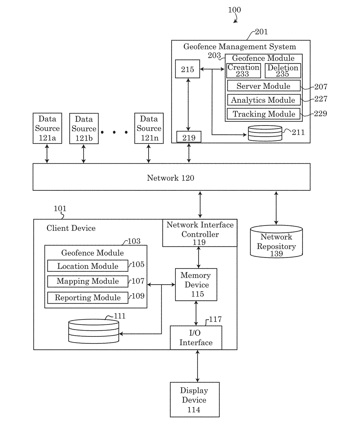
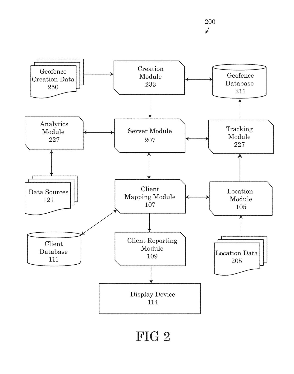
[0016]Embodiments of the present disclosure recognize that currently available geofence systems and client devices retrieving geofences may be limited to a preset number of geofences that may be loaded into the client device and / or displayed by the device. Client devices, such as mobile computing systems operating on the Android operating system may be limited to retrieving and storing 100 simultaneous geofences. Likewise, mobile computing devices equipped with an iOS operating system may be limited to merely 20 simultaneous geofences stored or accessible by the computing device. Often, the number of geofences available for retrieval and download onto the client device in a current location may exceed the maximum number of geofences that can be simultaneously stored and displayed by the client device. Accordingly, because of the limitations on the number of geofences by the operating systems of client devices, there is a need to prioritize the order in which active geofences...


PUM


Abstract

Systems, methods and tools for prioritizing the transmission of geofences based on the social influences and interactions with the geofences previously performed or discussed by associates of a user. Embodiments may search a user's social media connections and friend's lists for associates of the user that may have interacted with, commented about or used one or more of the geofences. As a function of the social influences of the user's associates, the disclosed systems, methods and tools may calculate a rating for each geofence based on the popularity of the geofence or probability that the user may enjoy interacting with the geofence. Embodiments may prioritize the transmission of the geofences being downloaded to the user's client device as a function of the ratings assigned, therefore downloading and displaying the most popular geofences and / or the geofences most likely to appeal to the user first.

Description

TECHNICAL FIELD[0001]The present disclosure relates generally to systems, methods and tools for creating, displaying and prioritizing geofences.BACKGROUND[0002]As portable devices, such as mobile communication systems, smart phones, tablet computers, laptops and navigation devices, become more advanced and powerful, these portable devices increasingly provide locational guidance to users in real time. More recently, portable devices have introduced a concept known as geo-fencing. A geofence is a virtual perimeter around a real-world location. Portable devices that implement geo-fencing functionalities may alert the user when the portable device has entered or exited an established geofence.[0003]A geofence may be a circular or polygon defined area around a point on a map that is often defined by the areas latitude and longitude. Programs that incorporate geo-fencing allow an administrator of a geofence to set up triggers so when a device enters (or exits) the boundaries of the geofe...

Claims


Application Information

Patent Timeline
IPC IPC(8): H04W24/00H04W4/02H04W4/021
CPCH04W4/021H04W4/023
Inventor DELUCA, LISA SEACATGREENBERGER, JEREMY A.
Owner HCL TECH LTD
Features
  • R&D
  • Intellectual Property
  • Life Sciences
  • Materials
  • Tech Scout
  • Unparalleled Data Quality
  • Higher Quality Content
  • 60% Fewer Hallucinations
Learn More