AI technical title is built by Patsnap AI team. It summarizes the technical point description of the patent document.
A technology of line segment and line method, applied in the field of spatial information processing, to achieve the effect of improving algorithm efficiency, improving overall performance, and improving line segment intersection performance
Active Publication Date: 2011-09-14
BEIJING SUPERMAP SOFTWARE CO LTD
View PDF0 Cites 0 Cited by
Summary
Abstract
Description
Claims
Application Information
AI Technical Summary
This helps you quickly interpret patents by identifying the three key elements:
Problems solved by technology
Method used
Benefits of technology
Problems solved by technology
[0008] The technical problem to be solved by the present invention is to provide a method and device for intersecting line segments to solve the problems existing in the existing method for intersecting line segments
Method used
Image
Click on the blue label to locate the original text in one second.
Reading with bidirectional positioning of images and text.
Examples
Embodiment 1
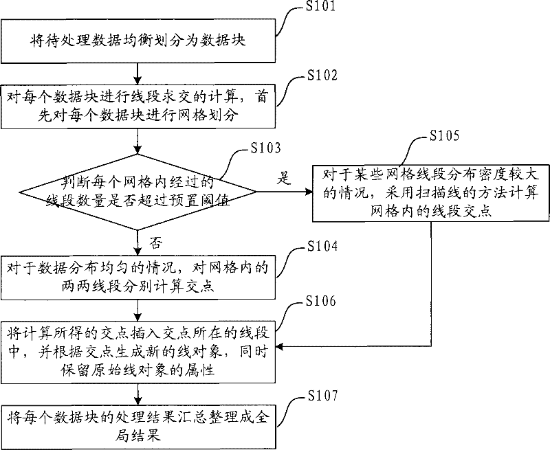
[0040] refer to figure 1 , is a flowchart of a method for intersecting line segments described in the embodiment.
[0041] S101. Evenly divide the data to be processed into data blocks, that is, logically divide the spatial data;
[0042] S102, performing line segment intersection calculation on each data block, first performing grid division on each data block;
[0043] Grid division is to divide a data block into multiple grids, that is, the line object of each line in the gridded data block, and all the line segments passing through the grid are kept in the grid. At this time, a line object in the data block Will be divided into multiple line objects.
[0044] S103, judging whether the number of passing line segments in each grid exceeds a preset threshold, if not, execute S104; if exceed, execute S105;
[0045] The judging criteria are used to measure whether the data distribution after gridding is uniform. If the data distribution is uniform, the distribution density ...
Embodiment 2
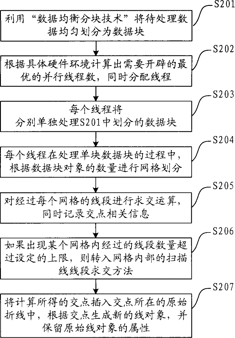
[0055] With the development of computer hardware equipment, mainstream computers have realized the transition from single-core, single-CPU to multi-core, multi-CPU. At present, most GIS spatial analysis algorithms are still based on the traditional single CPU implementation, so it is difficult to take advantage of the hardware on multi-core, multi-CPU machines, hindering performance improvement. In addition, with the rapid development of GIS technology, people have higher and higher requirements for the spatial analysis function of GIS software. It is becoming more and more difficult to adapt to the rapidly developing market demand of GIS.
[0056] Therefore, based on the above method, the present invention also provides a preferred embodiment. This embodiment makes full use of computer system resources, adopts the mode of parallel computing to simultaneously intersect the line segments of multiple data blocks, realizes the full utilization of multi-core and multi-CPU hardwar...
PUM
Abstract
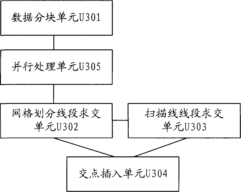
The invention discloses a method and a device for intersecting line sections, solving the problems of the prior line section intersecting method. The method comprises the following steps: the data to be processed is divided into data blocks, the intersecting calculation of the line sections of each data block is performed; each data block is meshed, whether the number of the line sections throughthe inner part of each grid is higher than the preset threshold value is judged, if not, the point of intersection of the line section inside the grid is calculated; if yes, the point of intersectionof the line section inside the grid is calculated by a scanning beam method; and the point of intersection obtained by calculating is inserted into the line section of the point of intersection. The method avoids the sharp decline of the intersecting efficiency of the line section caused by the imbalanced data distribution, and adopts the mode of parallel computation to process the intersection of the line section inside each data block, thereby further improving the calculation efficiency. The method realizes the sufficient adoption of the multi-core and multi-CPU hardware equipment, greatlyimproves the intersecting performance of the line sections, and provides the solid technical guarantee for the improvement of the whole performance of the space analysis.
Description
technical field [0001] The invention relates to spatial information processing technology, in particular to a method and device for intersecting line segments. Background technique [0002] Spatial Analysis is a spatial data analysis technology based on the location and morphological characteristics of geographic objects, and its purpose is to extract and transmit spatial information. The object of spatial analysis is spatial data, and the results of spatial analysis directly depend on the spatial location of the analysis object. Spatial analysis is the core and soul of GIS (Geographic Information System, geographic information system), and it is one of the main symbols that distinguish GIS from general information systems, CAD (Computer Aided Design, computer-aided design) or electronic map systems. [0003] Most of the functions of GIS spatial analysis involve the processing of the positional relationship between a large number of spatial objects, and these problems will ...
Claims
Application Information
Patent Timeline
Application Date:The date an application was filed.
Publication Date:The date a patent or application was officially published.
First Publication Date:The earliest publication date of a patent with the same application number.
Issue Date:Publication date of the patent grant document.
PCT Entry Date:The Entry date of PCT National Phase.
Estimated Expiry Date:The statutory expiry date of a patent right according to the Patent Law, and it is the longest term of protection that the patent right can achieve without the termination of the patent right due to other reasons(Term extension factor has been taken into account ).
Invalid Date:Actual expiry date is based on effective date or publication date of legal transaction data of invalid patent.

