Method for implementing map outline marker based on object-oriented programming language technology

A technology of object-oriented programming and map outline, which is applied in the direction of program control devices, special data processing applications, instruments, etc., can solve problems such as unclear display styles, visual confusion, and unintuitive primary and secondary information, and achieve rich information display forms, Rationalization of organization and the effect of enriching information display

Inactive Publication Date: 2009-08-05
LINKAGE SYST INTEGRATION
View PDF0 Cites 4 Cited by
  • Summary
  • Abstract
  • Description
  • Claims
  • Application Information

AI Technical Summary

Problems solved by technology

When the user repeatedly switches information, it may cause visual confusion. The primary and secondary information is not intuitive, and the display style is not clear. It is all tabular data.

Method used


Image

  • Method for implementing map outline marker based on object-oriented programming language technology
  • Method for implementing map outline marker based on object-oriented programming language technology
  • Method for implementing map outline marker based on object-oriented programming language technology

Examples


Embodiment approach

[0038] The specific implementation method is:

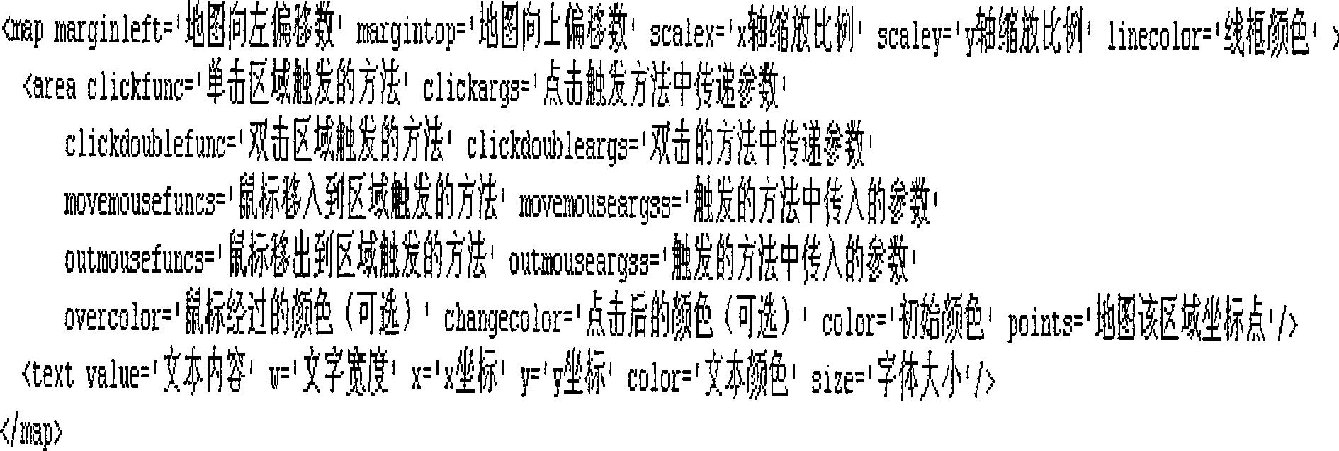
[0039] 1) The first step: write xml information and set the parameter information for map generation. The specification format of xml is defined as figure 2 .

[0040] Among them, the area and text tags can be defined repeatedly, each area represents an area, and text represents text remarks. The color property is to set the area background color. The linecolor and linewidth are to set the color and size of the line between regions. It is to set the area information description. The clickfunc, clickargs, clickdoublefunc, clickdoubleargs, movemousefuncs, movemouseeargss, outmousefuncs, outmouseeargss attributes are the trigger event information of the setting area. The points attribute is to set the outline information of the map. The marginleft, margintop, scalex, and scaley are to set the map zoom function.

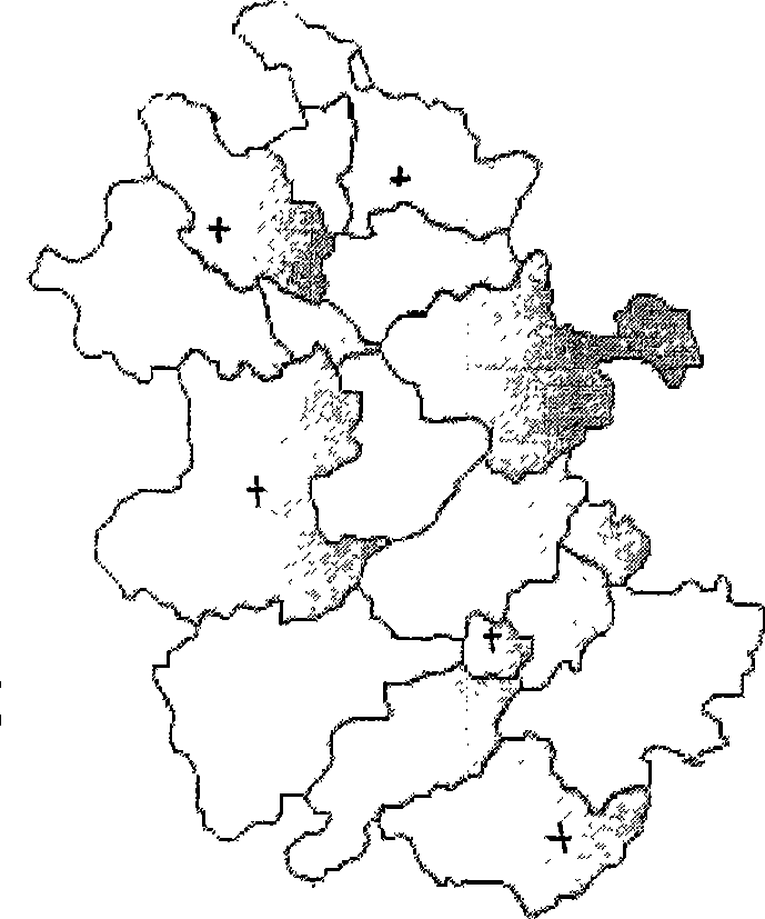
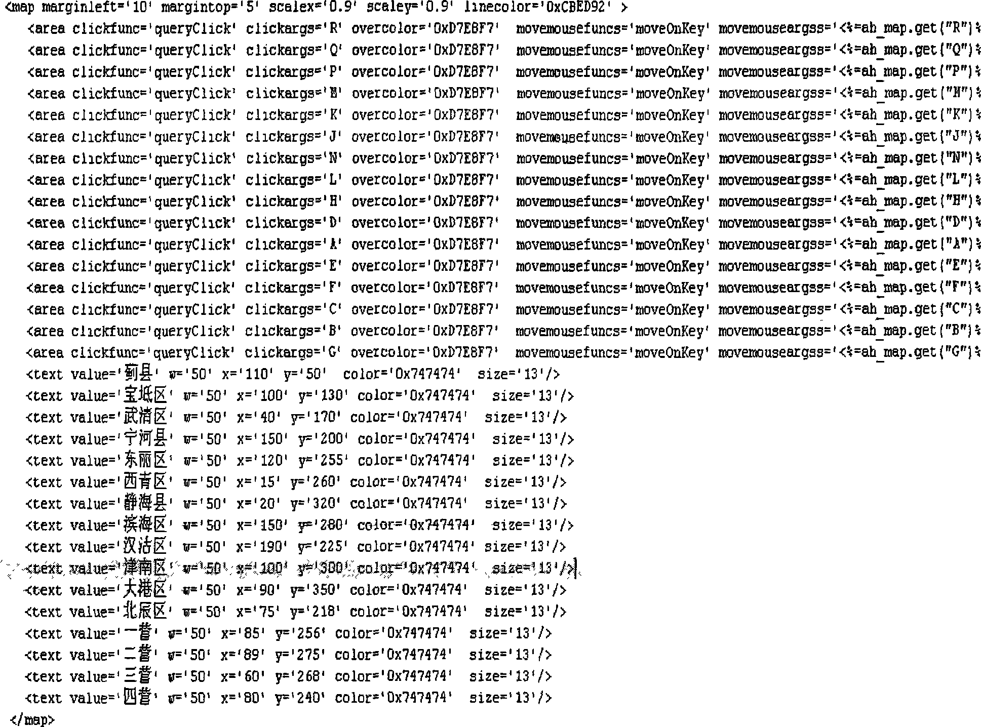
[0041] According to the needs of Anhui, the specific definition of the xml file is as follows image 3 :...


PUM


Abstract

A method for realizing map outline symbol based on a programming language technology facing to the object displays the map information by using an actionscript technology to write the map outline symbol and by means of translating and editing actionscript to form a flash, and displays the map information on a web browser, supports the application of b/s; uses an xml file mode to exchange the data, defines the displaying information of the map outline via an appointed xml file format, then uses the mode of http protocol as the parameter to transfer to a map flash to dynamically generates the map information; defines the map information via the xml mode; uses actionscript to realize the flash map and distributes the map which is better distributed to a system of b/s structure. Setting a plurality of map property information comprises background color of each region, line color and size between regions, region information description. The information displaying format is extended, and the simple mode is provided so as to display the development situation of each region.

Description

technical field [0001] The invention belongs to the technical category of displaying and applying technology of service data information of telecommunication operators, in particular to a method for realizing map contour logos based on ActionScript (object-oriented programming language) technology. Background technique [0002] Through years of development, telecom operators have become more and more mature in their business operation support systems. The current focus is gradually tilted towards the business analysis system, which needs to provide business decision-making and business analysis functions through the analysis system to enhance the operational value of telecommunications itself. Telecom leaders and analysts often log in to the business analysis system to obtain valuable information in their daily work. [0003] The current economic and sub-information display is still in the form of traditional tables and graphics. When a user visits a thematic area, he firs...

Claims


Application Information

Patent Timeline
Patent Type & Authority Applications(China)
IPC IPC(8): G06F9/44G06F17/30
Inventor 吴宏伟赵懿敏庞海东李捷曹晓华
Owner LINKAGE SYST INTEGRATION
Why Eureka
Try Eureka