Method and system for processing high-definition remote sensing image data

An image data and image technology, applied in the field of high-resolution remote sensing image data processing and its systems, can solve the problems of large-scale basic geographic information processing technology and method system lag, etc.

Inactive Publication Date: 2009-12-16
CHINESE ACAD OF SURVEYING & MAPPING
View PDF0 Cites 107 Cited by
  • Summary
  • Abstract
  • Description
  • Claims
  • Application Information

AI Technical Summary

Problems solved by technology

[0007] At present, the processing technology of medium and low-resolution remote sensing information is relatively mature, but the processing technology and method system for extracting large-scale basic geographic in

Method used


Image

  • Method and system for processing high-definition remote sensing image data
  • Method and system for processing high-definition remote sensing image data
  • Method and system for processing high-definition remote sensing image data

Examples


Embodiment Construction

[0048] In order to make the object, technical solution and advantages of the present invention clearer, the implementation manner of the present invention will be further described in detail below in conjunction with the accompanying drawings.

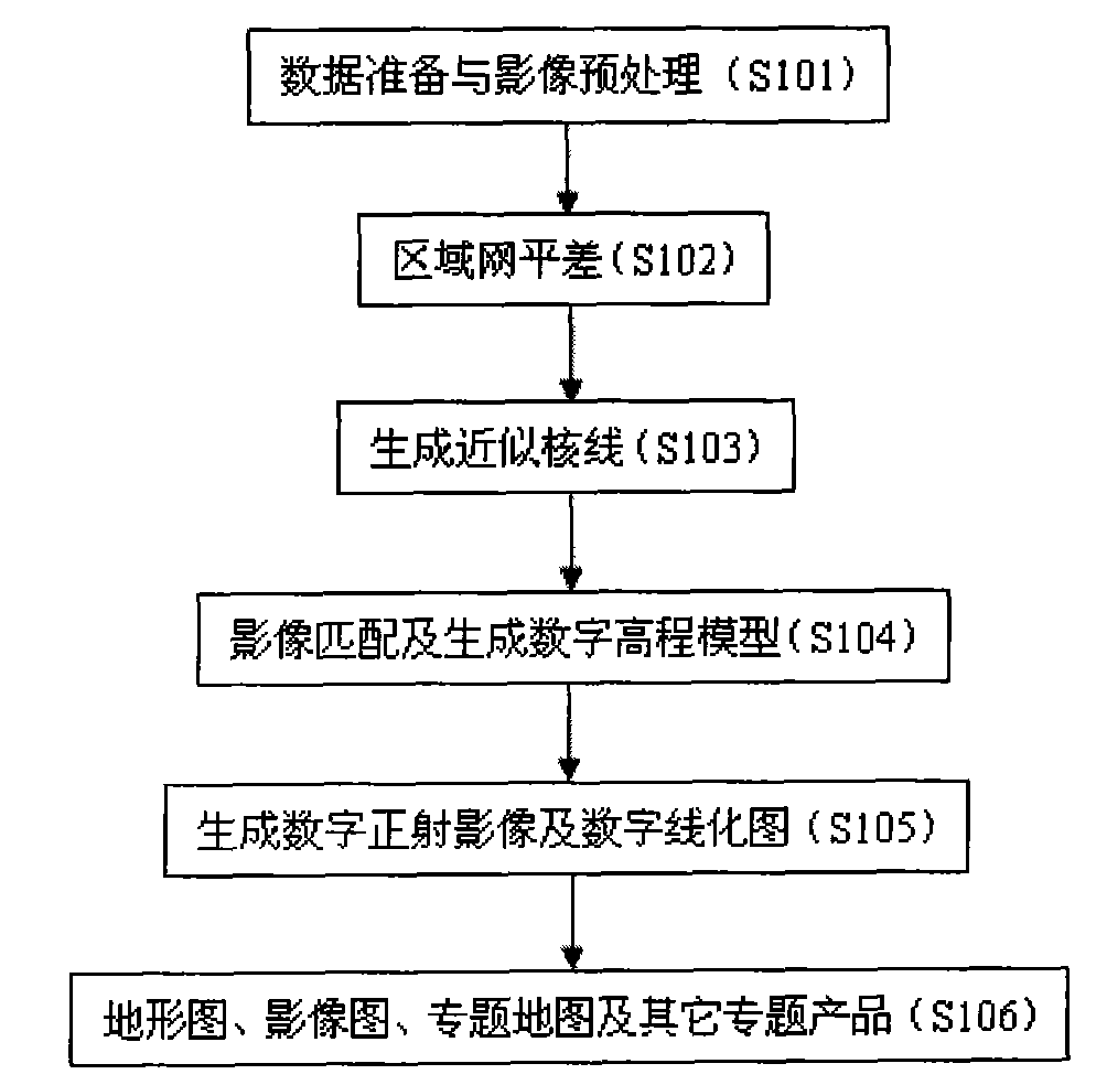
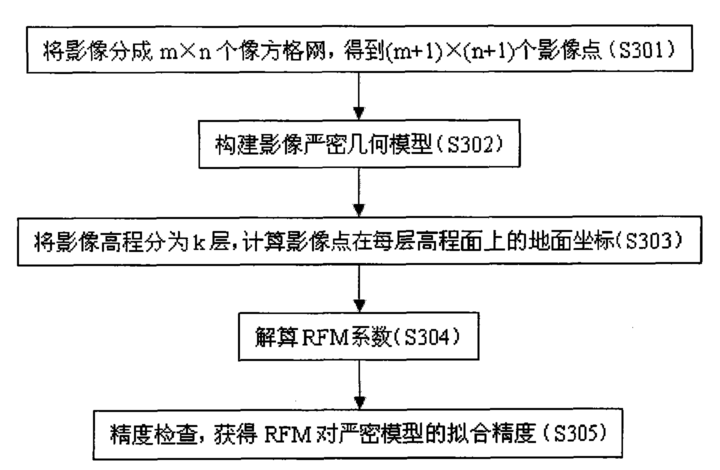
[0049] First, refer below figure 1 Describe the high-resolution remote sensing image data processing method of the present invention. figure 1 The basic flow of high-resolution remote sensing image data processing is shown. refer to figure 1 , the high-resolution remote sensing image data processing method of the present invention, in step S101, calculates rational function model (RFM) parameters for the input image by performing data analysis on the original remote sensing image (pair) directly acquired by the satellite.

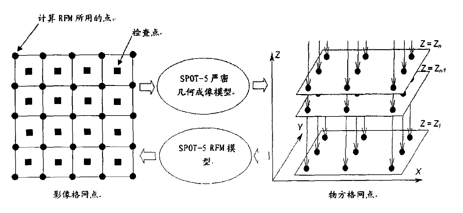
[0050] Using RFM, it is necessary to calculate the parameters of RFM, an alternative model of its strict geometric imaging model, based on the imaging mechanism of satellite images and the ephemeris parameters and...


PUM


Abstract

The invention provides a method and a system for processing high-definition remote sensing image data by applying a rational function model, a satellite image block adjustment and auto-match and distributed parallel processing technology. The method comprises the following steps: analyzing and processing input primary image data and computing parameters of the corresponding rational function model so as to obtain a stereo image pair by applying the computed rational function model; performing measurement and singlechip orientation of a control point and a connecting point on the primary image data, and performing block adjustment processing on an error between stereo image pixel data and the primary image data so as to improve the fit precision between the stereo image pixel data and the primary image data; generating an image similar to an epipolar ray, defining a matching template, measuring matched seed points and lines, performing automatic image matching and generating a digital elevation model; and respectively generating a digital orthophoto map and a digital line graph, and finishing manufacturing a product by applying the obtained data.

Description

technical field [0001] The present invention relates to a method and system for processing high-resolution remote sensing image data and a corresponding computer product program, in particular to the use of rational function models, regional network adjustment of satellite images with sparse or no ground control in large areas, and multi-baseline multi-matching features A method and system for automatic matching and high-speed network-based distributed parallel processing technology for processing high-resolution remote sensing image data, and a corresponding computer product program. Background technique [0002] Since the beginning of the 21st century, space technology and information technology have been further developed, and the demand for geographic information resources has grown rapidly. All countries in the world regard geographic information resources as important strategic information resources. With the accumulation of a large amount of geographic information dat...

Claims


Application Information

Patent Timeline
IPC IPC(8): G01S7/48
Inventor 张力张继贤燕琴谢文寒程春泉高武俊许骥袁枫孙钰珊
Owner CHINESE ACAD OF SURVEYING & MAPPING
Why Eureka
Try Eureka