Improved physical method for topographic correction of remote sensing images
A technology for terrain correction and remote sensing imagery, applied in the field of remote sensing
- Summary
- Abstract
- Description
- Claims
- Application Information
AI Technical Summary
Problems solved by technology
Method used
Image
Examples
Embodiment Construction
[0014] 1. Calculation of direct solar radiation
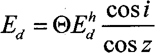
[0015] The direct solar radiation received by a pixel on a slope surface can be converted from the direct radiation received by its corresponding horizontal pixel through cosine correction. The specific conversion formula is as follows:
[0016] E d = Θ E d h cos i cisz (Formula 1)
[0017] In the formula: E d is the direct solar radiation received by the pixel on the slope, E d h is the direct solar radiation received by the pixel on the horizontal plane, obtained from the 6S model. i is the angle of incidence of the sun on the slope (the angle between the direct sunlight and the normal of the slope), and z is the zenith angle of the sun. Θ is the terrain shadow coefficient, if the slope is a shadow area (cosi<0), Θ is 0, otherwise it is 1; the sun inc...
PUM
 Abstract
Description
Claims
Application Information
 - R&D
- Intellectual Property
- Life Sciences
- Materials
- Tech Scout
- Unparalleled Data Quality
- Higher Quality Content
- 60% Fewer Hallucinations
Browse by: Latest US Patents, China's latest patents, Technical Efficacy Thesaurus, Application Domain, Technology Topic, Popular Technical Reports.
© 2025 PatSnap. All rights reserved.Legal|Privacy policy|Modern Slavery Act Transparency Statement|Sitemap|About US| Contact US: help@patsnap.com


