Constructing method for topographic correction vegetation index

A vegetation index and terrain correction technology, which is applied to the reflection/re-radiation of radio waves, the use of re-radiation, measurement devices, etc., which can solve the problem of insufficient quantitative inversion of vegetation information in mountainous areas, cannot achieve terrain correction effects, and cannot cover the entire image. and other problems, to achieve the effect of eliminating differences in vegetation information, suitable terrain correction effect, and significant terrain correction effect.

CN101561502AInactive Publication Date: 2009-10-21FUZHOU UNIV
0 Cites 32 Cited by

Patent Information

Authority / Receiving Office
CN · China
Patent Type
Applications(China)
Current Assignee / Owner
Publication Date
2009-10-21
Estimated Expiration
Not applicable · inactive patent

Smart Images

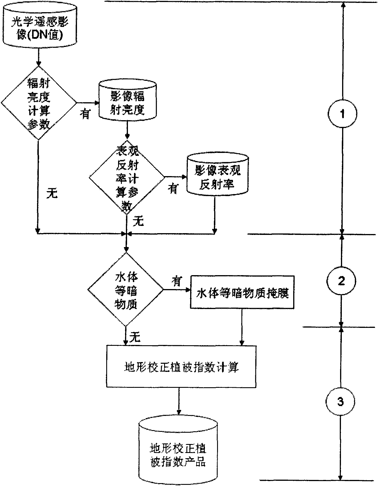
  • Figure 1
    Figure 1
Patent Text Reader

Abstract

The invention relates to a constructing method for topographic correction vegetation index, comprising the following steps of: (1) carrying out radiative correction with different degrees according to obtained optical remote sensing image data source; (2) carrying out judgment and processing to nonvegetated dark matters; and (3) carrying out calculation to topographic correction vegetation index (TCVI). The method is adopted to construct the topographic correction vegetation index, thus making up the defect that the existing vegetation index can not eliminate topographic influence and eliminating the dependence to the topographic correction method based on DEM data. The invention can quantitatively and fast reflect the vegetable information of mountain areas only by needing two wave bands of data, namely an infrared wave band and a near-infrared wave band.
Need to check novelty before this filing date? Find Prior Art

Description

technical field

[0001] The invention relates to a method for constructing terrain correction vegetation index. Background technique

[0002] Due to the influence of terrain in mountainous and hilly areas, there is a huge contrast in the band radiance information between the shady and sunny slopes of the mountain in optical remote sensing images, which seriously affects the accuracy of remote sensing quantitative inversion of vegetation information in mountainous areas.

[0003] The current inversion of vegetation information from optical remote sensing images mainly uses the method of vegetation index. The most commonly used vegetation indices are Normalized Difference Vegetation Index NDVI, Ratio Vegetation Index RVI, etc.; indices proposed to eliminate atmospheric influences include anti-atmospheric vegetation index ARVI, greenness anti-atmospheric vegetation index GARVI, visible light anti-atmospheric index VARI, etc. ; There are also indices proposed to eliminate the in...

Examples

Embodiment Construction

[0018] The construction method of terrain correction vegetation index of the present invention, this method comprises the following steps:

[0019] (1) Image radiation correction, corresponding to figure 1 In ①, according to the conditions of the obtained optical remote sensing image data source, different degrees of radiation correction are performed. If there are radiance calculation parameters, such as the Gain and Bias parameters of each band of the sensor, the radiance value of the relevant band data can be calculated from the DN value of each band data of the remote sensing image; if there are further calculation parameters about the apparent reflectance, For example, parameters such as the solar spectral irradiance of the corresponding wavelength at the top of the atmosphere can further calculate the apparent reflectance of the top of the atmosphere in the relevant band. Radiation correction can improve the final inversion accuracy of terrain-corrected vegetation index...