Ontology-driven geographic information retrieval system and method

A technology of geographic information and ontology, applied in the fields of electrical digital data processing, special data processing applications, instruments, etc.

Inactive Publication Date: 2010-08-11
CHINESE ACAD OF SURVEYING & MAPPING
View PDF3 Cites 38 Cited by
  • Summary
  • Abstract
  • Description
  • Claims
  • Application Information

AI Technical Summary

Problems solved by technology

[0007] The invention uses ontology to describe the semantic, time sequence, and spatial relationships of geospatial events, and solves the technology of geospatial event ontology construction, ontology spatial relationship and semantic relationship reasoning, and ontology-based intelligent retrieval and user-based personalized geographic services. problem, establish an ontology-driven geospatial event information retrieval mechanism, create a corresponding search engine, and realize automatic retrieval, on-demand filtering, intelligent organization and personalized display of geospatial event information

Method used


Image

  • Ontology-driven geographic information retrieval system and method
  • Ontology-driven geographic information retrieval system and method
  • Ontology-driven geographic information retrieval system and method

Examples


Embodiment Construction

[0048] In order to enable those skilled in the art to better understand the technical solution of the present invention, and to make the above-mentioned purpose, features and advantages of the present invention more obvious and understandable, the present invention will be further described in detail below in conjunction with the embodiments and accompanying drawings .

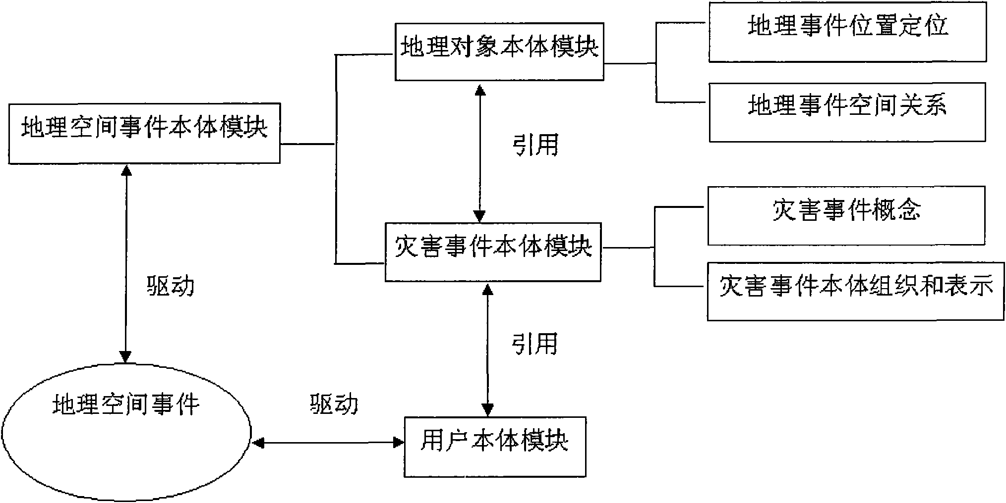
[0049] The ontology-driven geographic information retrieval system and retrieval method of the present invention are different from the traditional geographic information retrieval mechanism that only uses keywords for matching and querying. It takes geospatial events (tasks) as a link, and establishes a geospatial event ontology module ( Including two kinds of ontology sub-modules such as geographic object ontology module and disaster event ontology module), it conducts association analysis and reasoning on three types of information related to geospatial events, such as semantics, timing, and space, and under...


PUM


Abstract

The invention provides an ontology-driven geographic information retrieval system and an ontology-driven geographic information retrieval method, and a corresponding geographic space event ontology library and a construction method thereof. By utilizing an ontology to describe relationships among semantics, timing sequence, space and other aspect of a geographic space event, the technical problems of geographic space event ontology construction, ontology space relationship and semantics relationship inference and ontology-based intelligent retrieval and user-based personalized geographic service are solved; and an ontology-driven geographic space event information retrieval mechanism is established and a corresponding search engine is created, so automatic search, on-demand filtering, intelligent organization and personalized display of the geographic space event information are realized.

Description

technical field [0001] The present invention relates to a geospatial information system, and more specifically, to an ontology-driven geographic information retrieval system and retrieval method, as well as a corresponding geospatial event ontology library and a construction method thereof. Background technique [0002] At present, various application systems and databases based on spatial information are developing rapidly, and have penetrated into various fields such as resources, environment, disasters, and sustainable social development. Taking disaster events as an example, major emergencies established by the state are divided into 4 categories, 15 subcategories and 95 subcategories, including natural disasters, accident disasters, public health incidents and public safety incidents. After analysis, 97% of them are directly related to spatial location. or indirectly related. However, spatial information has the characteristics of massive, heterogeneous, and complex re...

Claims


Application Information

Patent Timeline
Patent Type & Authority Applications(China)
IPC IPC(8): G06F17/30
Inventor 栗斌
Owner CHINESE ACAD OF SURVEYING & MAPPING
Why Eureka
Try Eureka