Multi-angle map implementation method of three-dimensional simulation city

A three-dimensional simulation and three-dimensional map technology, which is applied in the field of three-dimensional simulation city map transformation, can solve the problem that users cannot observe cities and other problems, and achieve the effect of improving browsing speed.

Active Publication Date: 2010-10-27
HUAWEI TEHCHNOLOGIES CO LTD
View PDF4 Cites 54 Cited by
  • Summary
  • Abstract
  • Description
  • Claims
  • Application Information

AI Technical Summary

Problems solved by technology

[0003] However, the traditional 3D simulation city map displays data from a certa

Method used


Image

  • Multi-angle map implementation method of three-dimensional simulation city
  • Multi-angle map implementation method of three-dimensional simulation city

Examples


Embodiment Construction

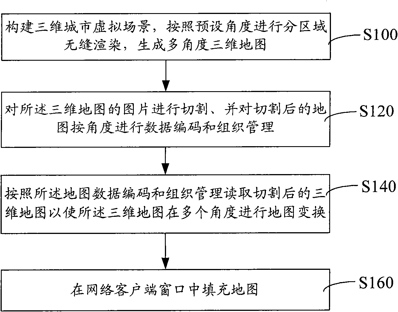
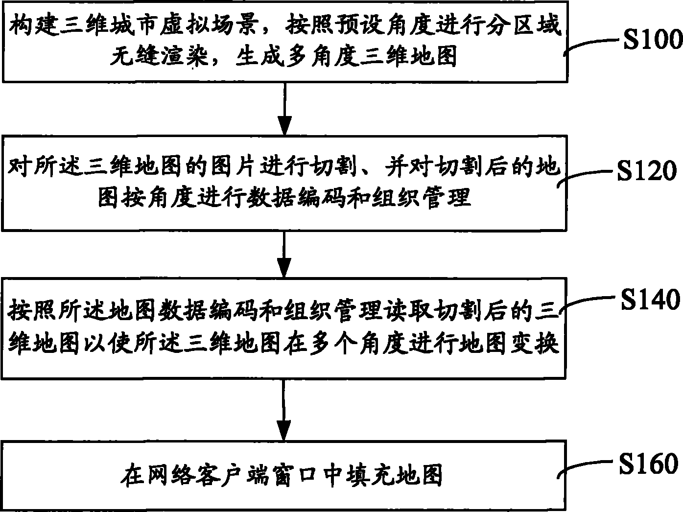
[0016] figure 1 A flowchart of a method for realizing a multi-angle map of a three-dimensional simulated city is shown. The specific process is as follows:

[0017] In step S100, a three-dimensional city virtual scene is constructed, and sub-area seamless rendering is performed according to preset angles to generate a multi-angle three-dimensional map.

[0018] First, model the 3D architectural data through 3D design software, or import 3D model data to construct a 3D urban virtual scene. For the 3D model, either the modeling method or the generated building model can be used for data production. If the remodeling method is adopted, it is necessary to conduct three-dimensional digital measurement of the existing buildings and features in the city to obtain the three-dimensional structure information of the features, and to photograph the features to obtain the texture information, so far combining the three-dimensional structure information of the features and Texture infor...


PUM


Abstract

The invention provides a multi-angle map implementation method of a three-dimensional simulation city, comprising the following steps: establishing a three-dimensional city virtual scene, and carrying out zoning seamless rendering according to a preset angle to generate a multi-angle three-dimensional map; cutting pictures of the three-dimensional map, and then carrying out data encoding and organizational management on the cut map according to the angle; reading the cut map according to data encoding and organizational management of the map so as to carry out map transformation on the three-dimensional map from multiple angles; and finally filling the map in the window of a network client. In the method, the pictures of the three-dimensional map are cut and data encoding and organizational management on the cut map are performed according to the angle, thus achieving fast loading display of a browser, improving browsing speed, and realizing browse among a two-dimensional map, a remote sensing map and the multi-angle three-dimensional map at the network client without installing a plug-in unit.

Description

【Technical field】 [0001] The invention relates to a method for transforming a three-dimensional simulated city map, in particular to a method for realizing a multi-angle map of a three-dimensional simulated city. 【Background technique】 [0002] In recent years, 3D simulation cities have become an important means for major cities to show their style. 3D simulation cities can observe city information from multiple perspectives, and present three-dimensional, colorful maps to the public. The map display mode of 3D simulation cities It has gradually replaced the fixed pattern in the two-dimensional map with simple patterns and insufficient three-dimensional and intuitive information description. [0003] However, the traditional 3D simulation city map displays data from a certain angle, which cannot satisfy users to observe the city from multiple directions. 【Content of invention】 [0004] Based on this, it is necessary to provide a method for realizing a multi-angle map of a...

Claims


Application Information

Patent Timeline
IPC IPC(8): G06T17/50G06T17/05
Inventor 马琪胡金星
Owner HUAWEI TEHCHNOLOGIES CO LTD
Why Eureka
Try Eureka