Hierarchical retrieval method for multi-source remote sensing resource heterogeneous databases

A remote sensing data and database technology, applied in the field of retrieval, can solve the problems of traditional remote sensing resources that cannot be retrieved across databases, etc.

Inactive Publication Date: 2011-06-01
HARBIN INST OF TECH
View PDF3 Cites 18 Cited by
  • Summary
  • Abstract
  • Description
  • Claims
  • Application Information

AI Technical Summary

Problems solved by technology

[0004] Aiming at the problem that traditional remote sensing resources cannot be retrieved across databases and the retrieval speed i...

Method used


Image

  • Hierarchical retrieval method for multi-source remote sensing resource heterogeneous databases
  • Hierarchical retrieval method for multi-source remote sensing resource heterogeneous databases
  • Hierarchical retrieval method for multi-source remote sensing resource heterogeneous databases

Examples


specific Embodiment approach

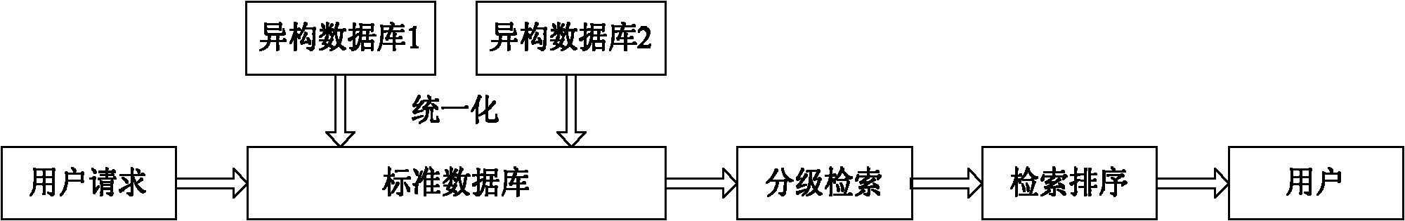
[0024] Specific implementation method: see figure 1 To illustrate this embodiment, the specific process of the multi-source remote sensing resource heterogeneous database hierarchical retrieval method described in this embodiment is as follows:

[0025] Step 1: Unify the databases in the distributed remote sensing data centers, and store all the unified data in the local database;

[0026] Step 2: perform hierarchical retrieval on all data in the local database;

[0027] Step 3: Sorting the retrieval results obtained in Step 2 to obtain the final retrieval results.

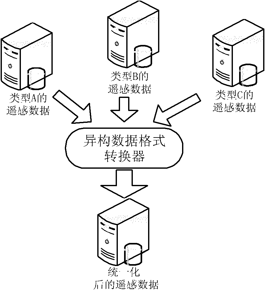
[0028] The first step is mainly to unify and standardize the format of distributed heterogeneous remote sensing resources, so as to realize the collaborative service of distributed heterogeneous remote sensing resources. The heterogeneous database of remote sensing resources is a database used to store remote sensing resources. For the unification and standardization process of all heterogeneous databases of rem...

specific Embodiment approach 2

[0050] Embodiment 2: The difference between this embodiment and Embodiment 1 is that the method further includes: regularly and periodically acquiring data from each distributed data center to update the local database.

[0051]Since the data of the distributed data centers are updated daily or weekly, in order to allow users to obtain the latest remote sensing data. In this embodiment, a step for implementing data update is added. This step is used to regularly obtain the update resources of the heterogeneous remote sensing resource database. This step is implemented by timer programming, and corresponding parameter adjustments can be performed on the update time and update time interval , so that the data of each distributed data center can be obtained at a specific time and at a specific interval to update the local database, so that the local data center can be synchronized with each distributed data center, so that users can obtain the latest data.

specific Embodiment approach 3

[0052] Specific embodiment three: The difference between this embodiment and the method described in the specific implementation of equation 1 or 2 is that the method also includes the step of performing optimal sorting on all data in the spatial filtering data set, and then the spatial filtering data after the optimal sorting The set is output as the final retrieval result.

[0053] In the actual search process, many researchers have found that users not only care about the correctness of search results, but also the ranking of search results greatly affects the user's search experience. When each document in the retrieval results is assigned a reasonable score according to its own relevance and importance as a sorting basis, the returned query results are satisfactory; on the contrary, if the scoring results of the documents in the retrieval results are not reasonable , resulting in a poor user experience.

[0054] In the step of optimizing the sorting, according to the act...


PUM


Abstract

The invention relates to a hierarchical retrieval method for multi-source remote sensing resource heterogeneous databases and solves the problem that the traditional remote sensing resource cannot be subjected to cross-database retrieval and the problem that the retrieval speed is low in the prior art. The method comprises the following steps of: firstly, unifying databases distributed in each remote sensing data center at different places, and storing all the unified data in a local database so as to unify remote sensing resource heterogeneous cataloged databases and provide basis for the subsequent retrieval; secondly, performing hierarchical retrieval on all the data in the local database, wherein the hierarchical retrieval adopts two retrieval strategies, namely primary filtration and secondary filtration so as to reduce the calculated amount; and finally, sequencing the retrieval results and preferentially presenting the retrieval result with high quality to a user. By the method, efficient and stable spatial query of the remote sensing resource heterogeneous databases is realized through the unification of cataloged data and grading of spatial query.

Description

technical field [0001] The invention relates to a retrieval method, in particular to a retrieval method of a heterogeneous database of multi-source remote sensing resources. Background technique [0002] Remote sensing generally refers to the theory, method and applied science and technology of using sensors to detect the radiation and reflection characteristics of electromagnetic waves of objects, and analyzing the properties, characteristics and states of objects according to their characteristics. Remote sensing resources generally refer to different data types (visible light, multispectral, hyperspectral, SAR and infrared, etc.), different time phases and different resolutions (including time resolution, spatial resolution, etc.) , spectral resolution) data and related description information on the data and imaging process. Remote sensing resources have been widely used in environmental monitoring, regional planning, weather forecasting, water environment governance an...

Claims


Application Information

Patent Timeline
IPC IPC(8): G06F17/30
Inventor 陈雨时龚小川
Owner HARBIN INST OF TECH
Why Eureka
Try Eureka