Remote sensing image block sorting and storing method suitable for spatial query

A technology of remote sensing image and space query, applied in special data processing applications, instruments, electrical digital data processing, etc., to achieve the effect of reducing the impact

Inactive Publication Date: 2012-11-07
INST OF GEOGRAPHICAL SCI & NATURAL RESOURCE RES CAS +2
View PDF0 Cites 2 Cited by
  • Summary
  • Abstract
  • Description
  • Claims
  • Application Information

AI Technical Summary

Problems solved by technology

However, as the amount of image data continues to increase, the number of image data blocks increases sharply. For example, in the data organization of Google Earth, a quadtree with a height of 0-17 and a total of 18 layers is used to organize global data. The number of nodes can theoretically reach 2 32 =4 294 967 296, the number of image data blocks will inevitably have a non-negligible impact on the spatial query calculation

Method used


Image

  • Remote sensing image block sorting and storing method suitable for spatial query
  • Remote sensing image block sorting and storing method suitable for spatial query
  • Remote sensing image block sorting and storing method suitable for spatial query

Examples


Embodiment Construction

[0030] The present invention will be described in detail below in conjunction with the accompanying drawings and specific embodiments.

[0031] With wide 65536 pixels, high 65536 pixels, pixel depth is 8bit, size is the grayscale remote sensing image of 4075.95 trillion tiff format as example, illustrate the specific implementation steps of the present invention (such as figure 1 shown):

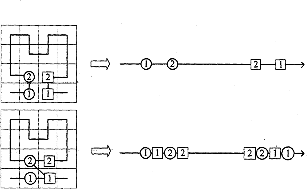
[0032] (1) Divide the entire image into 16384 image blocks according to the image block size of 512×512. Because it can be completely divided, there is no need to fill the edge block; if the image block at the edge of the image If the size is insufficient, fill it up with a null value.

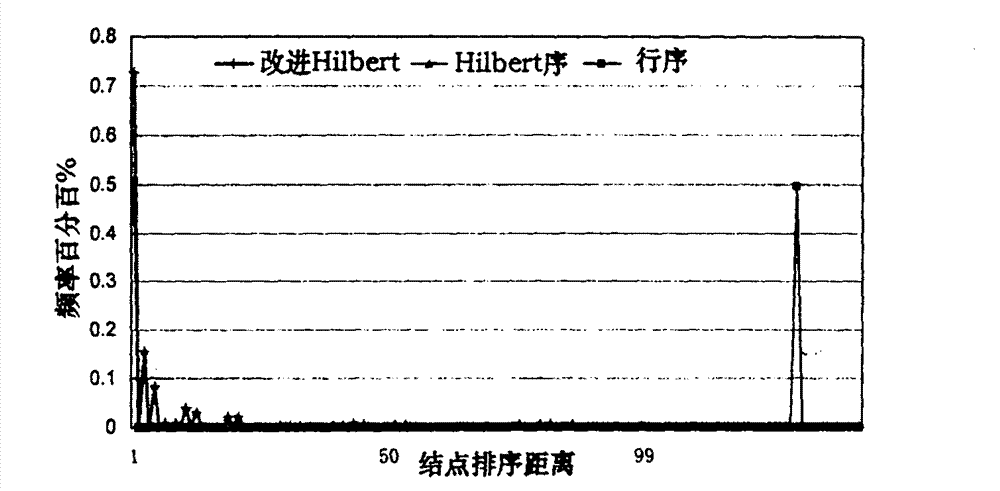
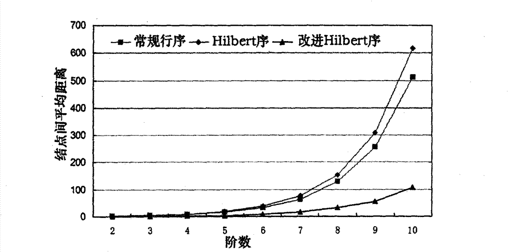
[0033] (2) Establish the Hilbert order with the upper left corner of the n=7 order as the entry point, where the Hilbert order is generated iteratively, such as figure 2 Shown is the Hilbert order of n from 1 to 3 order, until the Hilbert order of n=7 order is established. All the above 16384 image block...


PUM


Abstract

The invention relates to a remote sensing image block sorting and storing method suitable for spatial query, which comprises the following steps: regularly dividing an image into 22n image blocks from the top left corner; establishing a sorting queue for the image blocks according to the Hilbert sequence; marking front 2n-1 node pairs with maximum correlative sorting distance on the nth order of the Hilbert sequence, wherein each node pair comprises a node ai and a node bi, the ai and the bi indicate nodes in the node pair with maximum ith sorting distance, and i is greater than 0 and less than 2n-1+1, and inserting the nodes in the node pair into the sorting queue; repeating the marking and inserting operations in step 3 for n-1 orders corresponding to four quadrants of the Hilbert sequence until the mth order which is assigned by a user and meets performance requirements, and finally, generating a new sorting queue (i.e. improved Hilbert sequence); and according to the sequence in the sorting queue, storing practical image block data and minimum external frames of the blocks in an object-relational database. The invention provides an efficient method for organizing and storing alarge amount of image data on storage equipment, such as disks and the like, thereby improving the spatial query efficiency of remote sensing images.

Description

technical field [0001] The invention belongs to the technical field of spatial data query and processing, and relates to a remote sensing image segmentation and sorting storage method suitable for spatial query. The method is used to guide the optimal storage of massive remote sensing image data on storage devices such as disks. Background technique [0002] 80% of human information is related to geographical location and spatial distribution. Spatial data is widely used in many fields such as surveying and mapping, resource and environmental management. At present, due to the rapid development of remote sensing earth observation technology and communication technology, human beings have obtained more and more massive remote sensing image data. The current conventional storage methods in image data management cannot fully meet the efficient access requirements of massive remote sensing image data. The optimal storage of image data has become a difficult point in the promotio...

Claims


Application Information

Patent Timeline
Patent Type & Authority Patents(China)
IPC IPC(8): G06F17/30
Inventor 李飞陈荣国周成虎张明波程昌秀谢炯卢战伟颜勋陈应东赵彦庆景宁熊伟陈宏盛冯登国徐震张敏陈驰
Owner INST OF GEOGRAPHICAL SCI & NATURAL RESOURCE RES CAS
Why Eureka
Try Eureka