Positioning system of fire point of forest fire and using method thereof

A positioning system and fire point technology, applied in satellite radio beacon positioning systems, radio wave measurement systems, services based on location information, etc., to achieve the effect of improving plotting accuracy and saving time

Inactive Publication Date: 2012-05-23
BEIJING FORESTRY UNIVERSITY
View PDF3 Cites 6 Cited by
  • Summary
  • Abstract
  • Description
  • Claims
  • Application Information

AI Technical Summary

Problems solved by technology

[0007] In order to overcome the many troubles inevitably brought about in the existing forest fire fire spot location process, improve the positioning efficiency and accuracy, and realize the real-time transmission of t

Method used


Image

  • Positioning system of fire point of forest fire and using method thereof

Examples


Embodiment Construction

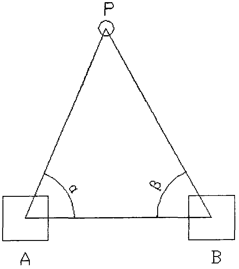
[0015] The forest fire fire point location method is different from the existing methods, and has been greatly improved, specifically: the method for forest fire fire point location measurement is as follows: set up instruments at observation points A and B, and its coordinates (X A , Y A ) and (X B , Y B ) is measured by the built-in GPS module; make A, B and fire point P form a single triangle PAB; measure the magnetic azimuth A of AP, the magnetic azimuth A1 of AB, and the magnetic azimuth B of BP through the built-in electronic compass , the magnetic azimuth angle B1 of BA, and the included angle α=|A-A1| between AP and AB, the included angle β=|B-B1| between BP and BA; through GPRS (X A , Y A ), (X B , Y B ), α, β four data are sent to the server, using the digital model ① Find the coordinates of fire point P (X P , Y P ).


PUM


Abstract

The invention discloses a positioning system of a fire point of a forest fire and a using method thereof. An electronic compass is used to measure angles; a GPS is used to collect positioning data; a PDA is used to carry out data storage; a GPRS is used to transmit the data to a server; and a model is used to carry out calculation to realize positioning of a fire point of a forest fire. According to the invention, unavoidable problems existing in a current forest fire point positioning process can be solved; positioning efficiency and precision can be improved; and real-time transmission of a fire point position can be realized.

Description

1. Technical field [0001] The invention relates to a fire point location system for forest fires, in particular to a method for using the fire point location system. 2. Technical Background [0002] So far, when plotting forest fire information, pencils and erasers are mainly used to draw on paper maps. However, in the actual field operation process, the above methods all have their shortcomings: [0003] ① When pencils and erasers are used to draw paper forest fire situation maps on paper maps, the maps are easily damaged; [0004] ② Forest fire information needs to be manually fed back to the paper map, which is slow, heavy workload, and prone to position deviation and low accuracy; [0005] ③Manual drawing is used, the plotting information is not uniform, the sharing of plotting results is poor, and the forest fire situation map cannot be transmitted in real time. [0006] Therefore, when collecting forest fire points, the traditional forest fire plotting method is slow...

Claims


Application Information

Patent Timeline
IPC IPC(8): G01S19/45H04W4/02
Inventor 冯仲科王佳
Owner BEIJING FORESTRY UNIVERSITY
Why Eureka
Try Eureka