Sparse dynamic ensemble selection-based SAR (synthetic aperture radar) image terrain classification method

A land object classification and image technology, applied in the field of image processing, can solve the problems of difficult adjustment of classifier parameters, unstable results, slow speed, etc., and achieve the effect of dynamic classifier selection algorithm and fast and improved classification effect.

Active Publication Date: 2012-08-29
XIDIAN UNIV
View PDF2 Cites 52 Cited by
  • Summary
  • Abstract
  • Description
  • Claims
  • Application Information

AI Technical Summary

Problems solved by technology

[0004] Among them, the SAR image classification method based on a single classifier is to input the training data into a single classifier. After learning, the classifier has the ability to classify and recognize. This type of method has a faster classification speed, but the adjustment of classifier parameters is difficult and the results are not good. Stable; the SAR image object classification method based on classif

Method used


Image

  • Sparse dynamic ensemble selection-based SAR (synthetic aperture radar) image terrain classification method
  • Sparse dynamic ensemble selection-based SAR (synthetic aperture radar) image terrain classification method
  • Sparse dynamic ensemble selection-based SAR (synthetic aperture radar) image terrain classification method

Examples


Embodiment Construction

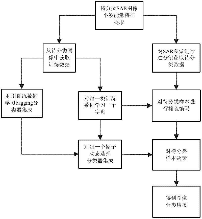
[0025] refer to figure 1 , the specific implementation steps of the present invention are as follows:

[0026] Step 1. Extract the wavelet energy features of the SAR image to be classified.

[0027] Take an M×N window for each pixel of the target SAR image and the auxiliary SAR image, and perform three-layer stationary wavelet decomposition on the window, obtain three-layer subband coefficients according to the wavelet decomposition, and calculate the wavelet energy feature of each pixel, if The total number of image pixels is n t , the 10-dimensional energy feature is extracted for each pixel by the following formula, and the size of the composition is n t ×10 input data sample E:

[0028] E = 1 M × N Σ i = 1 M Σ j = ...


PUM


Abstract

The invention discloses a sparse dynamic ensemble selection-based SAR (synthetic aperture radar) image terrain classification method, which mainly solves the problem that the speed of the conventional dynamic ensemble selection algorithm and the conventional dynamic classifier selection algorithm for terrain classification in SAR images is low. The implementation process of the sparse dynamic ensemble selection-based SAR image terrain classification method is as follows: (1) a wavelet energy feature is extracted from an SAR image to be classified; (2) training data is acquired from the SAR image to be classified; (3) the SAR image to be classified is regionalized to obtain data to be classified; (4) training samples are utilized to learn ensemble systems; (5) a dictionary is learnt for each class of training data, and a synthetic dictionary is obtained; (6) dynamic ensemble selection is carried out on each atom in the synthetic dictionary; (7) samples to be classified are sparsely coded; (8) the samples to be classified are marked according to a sparse coefficient and classifier ensembles corresponding to the atoms; (9) the marks of the samples to be classified are mapped onto pixels in the SAR image, so that a terrain classification result is obtained. The sparse dynamic ensemble selection-based SAR image terrain classification method has the advantages of high speed and good classification effect, and can be used for SAR image target identification.

Description

technical field [0001] The invention belongs to the technical field of image processing, and can be used for classification of SAR image ground objects and as a basis for further SAR image understanding and interpretation. Background technique [0002] Synthetic aperture radar (SAR) imaging technology actively emits and receives electromagnetic waves, and forms images according to the reflection and scattering characteristics of objects. It makes full use of the principle of synthetic aperture to improve azimuth resolution, and has unique advantages in the field of remote sensing. SAR has all-weather and all-weather detection and reconnaissance capabilities, and the interpretation of SAR images has received more and more attention from national defense and civilian use. As a very important step in SAR image interpretation, the classification of SAR image features becomes more and more important. [0003] The existing single-polarization SAR image object classification metho...

Claims


Application Information

Patent Timeline
IPC IPC(8): G06K9/62
Inventor 缑水平焦李成庄广安周治国刘芳杜芳芳张向荣
Owner XIDIAN UNIV
Why Eureka
Try Eureka