
Method and device for processing, abbreviating and progressively transmitting space data

一种空间数据、处理方法的技术,应用在图像数据处理、电数字数据处理、特殊数据处理应用等方向,能够解决空间信息传输数据量增长、效率和准确率低等问题

Active Publication Date: 2015-06-10
SUZHOU SUPERENGINE FOR GRAPHICS & IMASOFTWARE TECH DEV
View PDF3 Cites 0 Cited by
  • Summary
  • Abstract
  • Description
  • Claims
  • Application Information

AI Technical Summary

Problems solved by technology

Compared with the increase of the existing network bandwidth, the amount of data transmitted by spatial information is growing explosively, which is not conducive to real-time processing of spatial data, and the efficiency and accuracy of the processing process are relatively low.

Method used


Image

  • Method and device for processing, abbreviating and progressively transmitting space data
  • Method and device for processing, abbreviating and progressively transmitting space data
  • Method and device for processing, abbreviating and progressively transmitting space data

Examples


Embodiment Construction

[0124] The following will clearly and completely describe the technical solutions in the embodiments of the present invention with reference to the accompanying drawings in the embodiments of the present invention. Obviously, the described embodiments are only some, not all, embodiments of the present invention. Based on the embodiments of the present invention, all other embodiments obtained by persons of ordinary skill in the art without making creative efforts belong to the protection scope of the present invention.

[0125] For the convenience of description, in this application document, the spatial data to be processed is called the original spatial data, the coordinates of the spatial data to be processed are called the original coordinates of the original spatial data, and the coordinate points of the spatial data to be processed are called the original The original coordinate point of the spatial data, or directly called the original coordinate point.

[0126] The inv...


PUM


Abstract

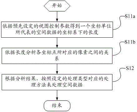
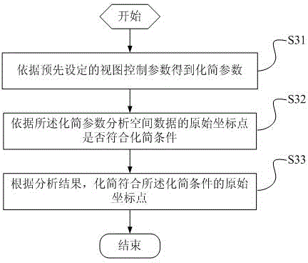
A method and a device for spatial data's processing, simplification and progressive transmission are provided, and the method comprises: analyzing the relationship of the pixels needed to be plotted when each coordinate point of the spatial data is displayed in the view window determined by the view control parameters according to preestablished view control parameters; processing the spatial data in accordance with a process method corresponding to a set process type, the processing procedure including a combination of any one or more of the spatial data's analysis, selection, simplification and progressive transmission according to the analysis result. The method makes the spatial data's processing procedure to be in accordance with the relationship of the pixels needed to be plotted when each coordinate point of the spatial data is displayed in the view window, and the method improves the efficiency and accuracy in the processing procedure.

Description

technical field [0001] The invention relates to the fields of spatial information technology, computer graphics and computer operating systems, in particular to a method and device for processing, simplifying and progressively transmitting spatial data. Background technique [0002] The view representation of spatial data is mainly displayed through an electronic map. An electronic map is a visual map that displays spatial data on an electronic screen through certain hardware and software. It is a grid of spatial data on an electronic screen (view window). display process. [0003] The view is an interface for selecting spatial data to be displayed in the view window according to the given spatial conditions. The process of displaying spatial data in the existing view is the process of rasterization of spatial data: first, the spatial data that meets the given spatial conditions is taken out through the spatial data index and transmitted to the spatial data user through the...

Claims


Application Information

Patent Timeline
Patent Type & Authority Patents(China)
IPC IPC(8): G06F17/30
CPCG06T17/05
Inventor 董福田
Owner SUZHOU SUPERENGINE FOR GRAPHICS & IMASOFTWARE TECH DEV
Learn More