Three-dimensional simulated electronic drawing for sea channels

A technology of 3D simulation and electronic diagram, applied in image data processing, 3D modeling, instruments, etc., can solve the problem of insufficient spatial cognition, restricting the progress of 3D representation technology of spatial information, 3DGIS engineering application practice, etc.

Inactive Publication Date: 2012-12-19
上海日浦信息技术有限公司
View PDF0 Cites 7 Cited by
  • Summary
  • Abstract
  • Description
  • Claims
  • Application Information

AI Technical Summary

Problems solved by technology

Existing 3D GIS researches are all focused on 3D visualization technology. The research on the more basic 3D GIS spatial cognition problem is not enough, which also restricts the progress of spatial information 3D representation technology and the engineering application practice of 3D GIS to a certain extent.

Method used


Image

  • Three-dimensional simulated electronic drawing for sea channels
  • Three-dimensional simulated electronic drawing for sea channels
  • Three-dimensional simulated electronic drawing for sea channels

Examples


Embodiment Construction

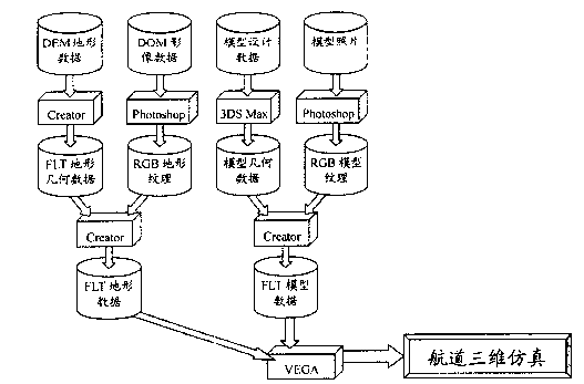
[0010] Such as figure 2 As shown, the generation of the three-dimensional simulation electronic map of the waterway is mainly formed by the real three-dimensional data provided by the spatial database through the interface graphics processing software independently developed by the front end. Using DEM terrain data to form FLT terrain geometry data through CREATOR tool, using DOM image data to form RGB terrain texture through PHOTOSHOP tool; using 3D model design data to form 3D model geometry data through 3DSMAX tool, using aerial photography model data to form RGB terrain through PHOTOSHOP tool texture. Then use FLT terrain geometry data and RGB terrain texture to form FLT terrain data through CREATOR tool; use 3D model geometry data and RGB terrain texture to form FLT terrain data through CREATOR tool; the two formed FLT terrain data form 3D simulation electronics of waterway in VEGA picture.

[0011] VEGA is a software system for developing real-time visual and audi...


PUM


Abstract

The invention discloses a three-dimensional simulated electronic drawing for sea channels. The three-dimensional simulated electronic drawing is formed by the following method: forming FLT (Fault-Locating Test) topography geometry data and RGB (Red, Green and Blue) topography texture, 3D geometry data and RGB topography data by utilizing the DEM (Digital Elevation Model) topographic data and DOM (Document Object Model) image data, editing 3D model design data and aerial photo model data through a CREATOR tool, a PHOTOSHOP tool and a 3DMAX tool; forming FLT topography data by utilizing a 3D model geometry data to lead the RGB topography texture through the CREATOPH tool; and forming three-dimensional simulated electronic drawing for sea channels in VEGA according to the two formed FLT topography data. The model of the three-dimensional simulated electronic drawing for sea channels expands the visualization concept; and through the mode, the visualization technology penetrates through the whole GIS (Geographic Information System) running process.

Description

technical field [0001] The invention belongs to electronic three-dimensional simulation technology, in particular to a three-dimensional simulation electronic map of a waterway. Background technique [0002] With the continuous development of computer three-dimensional (3D) display technology, the requirement for visualization of map symbols is becoming increasingly urgent. The contradiction between the abstraction and image of map symbols returns to three-dimensional visualization in the process of opposite and spiral development, which leads to the three-dimensional visualization of spatial information becoming one of the important features of GIS development. The 3D visualization technology makes the traditional 2D and static map representation develop towards the 3D and dynamic scene representation. With the support of the spatial database, virtual reality (VR) technology can be used to build a virtual environment. After entering this environment, people can use Comput...

Claims


Application Information

Patent Timeline
Patent Type & Authority Applications(China)
IPC IPC(8): G06F9/44G06T17/05
Inventor 不公告发明人
Owner 上海日浦信息技术有限公司
Why Eureka
Try Eureka