Load balancing method for geospatial data on cloud computing platform

A geospatial data and cloud computing platform technology, applied in the field of cloud computing, can solve problems such as not considering the unevenness of data partitioning, and the decrease in operating efficiency of the mapreduce model

Inactive Publication Date: 2013-02-13
NANJING UNIV OF POSTS & TELECOMM
View PDF2 Cites 16 Cited by
  • Summary
  • Abstract
  • Description
  • Claims
  • Application Information

AI Technical Summary

Problems solved by technology

However, this method does not consider the inhomogeneity between data blocks and the topological relationshi

Method used


Image

  • Load balancing method for geospatial data on cloud computing platform
  • Load balancing method for geospatial data on cloud computing platform
  • Load balancing method for geospatial data on cloud computing platform

Examples


Embodiment Construction

[0047] Below in conjunction with accompanying drawing, the technical scheme of invention is described in detail:

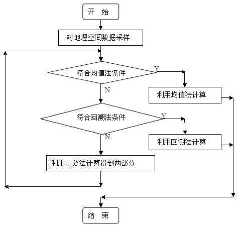
[0048] figure 1 It is the general flowchart of the load balancing method for geospatial data processing. This method considers the situation of geospatial data sampling data blocks, and comprehensively uses three algorithms (average method, backtracking method, and dichotomy method) to distribute geospatial data in a balanced manner. Process each mapping node. Specifically include the following steps:

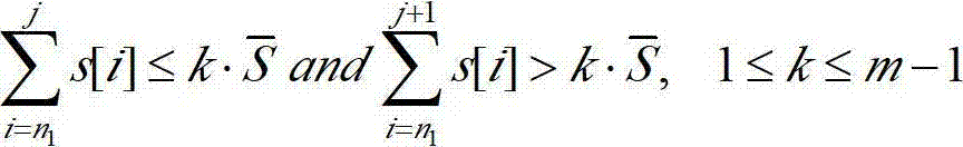
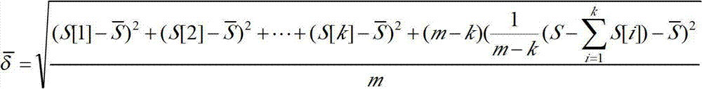
[0049] Step 1. Divide the geospatial data into a set of data blocks whose number increases according to the spatial distribution law according to the Hilbert space filling curve. Let the total number of data blocks after division be According to the sampling interval Sampling is performed to obtain the number of sampled data blocks as N, let s and p represent the data volume sequence of the sampled data block and the final position sequence to be divided respe...


PUM


Abstract

The invention discloses a load balancing method for geospatial data on a cloud computing platform. The method is characterized by comprising the following steps of: performing Hilbert space filling curve sorting on the geospatial data, sampling data blocks according to the data blocks divided by the geospatial data and number of map nodes during cloud platform processing to obtain the sampled data blocks; judging whether the sampled data blocks are suitable for a mean value method, if so, directly solving and dividing, otherwise judging whether the sampled data blocks are suitable for backtracking, if so, directly solving and dividing, otherwise dividing the sampled data blocks and the map nodes into two parts according to a bisection method, and repeating the previous operations on each part until all the sampled data blocks are correspondingly distributed to each map node; and finally, distributing an adjacent data block which corresponds to each sampled data block to each map node for processing.

Description

technical field [0001] The invention relates to a load balancing method for geospatial data on a cloud computing platform, and belongs to the technical field of cloud computing. Background technique [0002] Cloud computing is a business computing model that distributes computing tasks on a resource pool composed of a large number of computers, enabling various application systems to obtain computing power, storage space, and information services as needed. Now Google and the open source cloud computing platform Hadoop all use the map-reduce parallel computing model. This model provides a general and efficient technical framework for the processing of massive data, so it has been more and more widely used in geospatial data query processing, data mining and other fields. [0003] Geospatial data is multi-dimensional data. Geospatial data processing based on map-reduce first maps multi-dimensional spatial targets into one-dimensional targets (key / value key-value pairs). A c...

Claims


Application Information

Patent Timeline
IPC IPC(8): G06F17/30
Inventor 吴家皋周凡坤邹志强刘林峰
Owner NANJING UNIV OF POSTS & TELECOMM
Why Eureka
Try Eureka