A Road Acquisition Method of Remote Sensing Image Combining Kernel Fisher and Multi-scale Extraction

A technology of remote sensing image and acquisition method, which is applied in the field of linear surface object extraction, and can solve the problem of not fully considering the texture characteristics of the image

Active Publication Date: 2015-08-12
CHONGQING SURVEY INST
View PDF2 Cites 0 Cited by
  • Summary
  • Abstract
  • Description
  • Claims
  • Application Information

AI Technical Summary

Problems solved by technology

At present, only researchers have proposed "Hyperspectral Remote Sensing Image Classification Based on Kernel Fisher Discriminant Analysis" (Journal of Remote Sensing, 2008, 12(4): 579-585). Classification processing of remote sensing images with spatial resolution does not fully consider the texture features of images
The research on road extraction from high spatial resolution remote sensing images using kernel Fisher classification method has not been reported at home and abroad

Method used


Image

  • A Road Acquisition Method of Remote Sensing Image Combining Kernel Fisher and Multi-scale Extraction
  • A Road Acquisition Method of Remote Sensing Image Combining Kernel Fisher and Multi-scale Extraction
  • A Road Acquisition Method of Remote Sensing Image Combining Kernel Fisher and Multi-scale Extraction

Examples


Embodiment Construction

[0054] The present invention will be described in further detail below in conjunction with the accompanying drawings and specific embodiments.

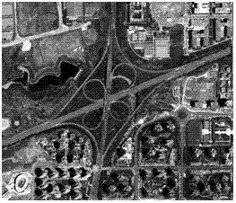
[0055] The present invention selects the size of a place as The WorldView-2 image is the research object, which provides a multispectral image with a spatial resolution of 1.88 meters including R, G, and B, such as image 3 shown. The present invention divides the features in remote sensing images into five categories: vegetation, water bodies and building shadows, bare land, buildings and roads;

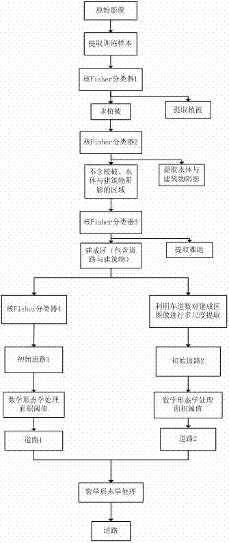
[0056] Concrete steps of the present invention are as follows, and its flow process sees figure 1 :

[0057] (1) Extraction of simple ground objects, which refer to vegetation, water bodies, shadows of buildings, and bare land;

[0058] For the vegetation, water and building shadows, and bare land, four objects with a size of The sample data of the sample data, the spectral characteristics of the sample data are normalized to obtai...


PUM


Abstract

The invention discloses a remote-sensing image road acquisition method combined with kernel Fisher and multi-scale extraction. The remote-sensing image road acquisition method combined with the kernel Fisher and the multi-scale extraction comprises the steps of extracting simple surface features (such as vegetation, shadows of water bodies and constructions, and bare lands), training a kernel Fisher classifier through spectral signature, achieving classification of the simple surface features, removing influences of the surface features on a road, to obtain a built-up area containing road and construction information, and extracting the road in the built-up area. On the one hand, the spectral signature and texture feature are simultaneously used for training the kernel Fisher classifier to divide the built-up area into the road and constructions. On the other hand, road information of common lane count is extracted in sequence according to the fact that different roads with different lane counts are different in width. Finally, road information obtained by kernel Fisher classification and road information obtained by the multi-scale extraction are combined and final road information is acquired. The remote-sensing image road acquisition method combined with the kernel Fisher and the multi-scale extraction improves effect of road extraction and improves accuracy of the road extraction.

Description

technical field [0001] The present invention relates to the extraction of linear objects, in particular to a method for obtaining road information from remote sensing images combined with kernel Fisher classification and multi-scale extraction. Spectral features, texture features and geometric features in remote sensing images effectively realize the extraction of urban road information, which belongs to the field of pattern recognition and remote sensing. Background technique [0002] As the backbone of modern urban traffic, roads have important geographical, political, and economic significance. Roads are also the main recording and identification objects in maps and geographic information systems. As basic geographic information, road information is an important part of geographic information data and the basic data of many geographic information system applications, such as vehicle navigation, traffic management, emergency response, etc. At present, with the rapid devel...

Claims


Application Information

Patent Timeline
Patent Type & Authority Patents(China)
IPC IPC(8): G06K9/46G06K9/62G06V10/44
CPCG06V20/182G06V10/44G06F18/2413
Inventor 楚恒马欢陈翰新向泽君王昌翰
Owner CHONGQING SURVEY INST
Why Eureka
Try Eureka