Geographic space lattice-based radar detection data processing method

A technology for detecting data and geographic space, which is applied in the field of meteorological detection, can solve the problems of unsatisfactory position accuracy and loss of numerical accuracy, and achieve the effect of meeting general needs

Inactive Publication Date: 2013-08-07
NANJING UNIV OF INFORMATION SCI & TECH
View PDF1 Cites 1 Cited by
  • Summary
  • Abstract
  • Description
  • Claims
  • Application Information

AI Technical Summary

Problems solved by technology

Although this method can achieve a certain matching effect, the position accuracy is often unsatisfactory, especially the image form of the data product records the color RGB value, rather than the specific numerical information such as the intensity of the radar echo, and it is difficult to integrate it based on GIS Spatial Data Analysis of Geographic Information
And these product data are given colors according to a certain range of values, which greatly loses the accuracy of the values

Method used


Image

  • Geographic space lattice-based radar detection data processing method
  • Geographic space lattice-based radar detection data processing method

Examples


Embodiment Construction

[0022] The solution of the present invention will be described in detail below with reference to the drawings.

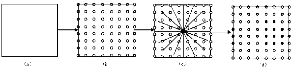
[0023] Such as figure 1 The method for processing basic reflectance product data of the first layer of radar based on the geographic space lattice provided in this embodiment includes the following steps:

[0024] (1) Within the range that can be detected by the radar, the latitude and longitude lines in the four directions of east, west, south and north are designated according to the latitude and longitude as the boundary to form a rectangular area as the geographic range of detection.

[0025] (2) In a rectangular area, according to the resolution requirements, the coordinate points are arranged according to the row and column spacing rules to form a geographical space lattice. The row and column spacing can be set to 0.01 degrees, which is approximately 1.11 kilometers from the ground.

[0026] (3) Obtain the azimuth angle and spherical distance of each point in the geog...


PUM


Abstract

The invention relates to a geographic space lattice-based radar detection data processing method, which comprises the following steps: (1) setting a rectangular geographic range to be detected; (2) in the rectangular geographic range, arranging coordinate points according to a line and row spacing rule under the requirement of resolution ratio to form a geographic space lattice; (3) acquiring an azimuth angle and a spherical distance of each point in the geographic space lattice relative to a radar; (4) clearing radar detection data corresponding to the current point to obtain a value of the point; (5) organizing values at the coordinate points in the lattice in a two-dimensional matrix storage structure, serializing data into binary data, and storing the binary data in a database; and (6) creating a data reading service interface, and calling radar product data stored in the database. The method has the advantages that a new way for processing, storing and sharing the radar detection data is provided, and a condition for counting and analyzing the radar detection data is also provided.

Description

Technical field [0001] The invention relates to the field of meteorological detection, in particular to a radar detection data processing method based on a geographical space lattice. Background technique [0002] With the development of detection technology, radar detection data has become more and more important and reliable weather detection data. However, radar product data is mostly in image format. With the development of GIS, how to match radar detection data with geographic information with precise location information for related data analysis is of great significance. At present, the "picture pulling" method is mostly adopted, that is, the boundary range of the radar detection data is first determined, and then the radar picture product data is forcibly "pulled" to the specified boundary range on the map. Although this method can achieve a certain matching effect, the position accuracy is often unsatisfactory, especially the image form of its data product records the c...

Claims


Application Information

Patent Timeline
Patent Type & Authority Applications(China)
IPC IPC(8): G01S7/02
Inventor 路明月闵锦忠范晓梅魏明尹静秋毕硕本邵一丹
Owner NANJING UNIV OF INFORMATION SCI & TECH
Why Eureka
Try Eureka