
A Remote Sensing Image Compression Method Based on Adaptive Direction Prediction Discrete Wavelet Transform

A discrete wavelet transform and direction prediction technology, which is applied in image communication, image coding, image data processing, etc., can solve the problems such as the inability to effectively use the direction information of remote sensing images, high computational complexity, and insufficient number of directions for enhanced wavelets, reaching a peak value. The effect of improving the signal-to-noise ratio, reducing the computational complexity, and improving the compression efficiency

Active Publication Date: 2016-08-10
BEIJING NORMAL UNIVERSITY
View PDF2 Cites 0 Cited by
  • Summary
  • Abstract
  • Description
  • Claims
  • Application Information

AI Technical Summary

Problems solved by technology

[0007] In order to overcome the shortcomings of the traditional lifting wavelet that cannot effectively use the direction information of remote sensing images, and the traditional direction wavelet transform has high computational complexity and insufficient number of directions, the present invention constructs a direction discrete wavelet that can make full use of the characteristics of remote sensing images and can be quickly realized transform, which can effectively concentrate the energy of various edges or texture directions in the image, relying on the new directional discrete wavelet transform designed in the present invention, a fast and efficient remote sensing image compression method is realized, thereby significantly improving the remote sensing image The compression efficiency of the reconstructed image is significantly improved in both subjective quality and objective evaluation.

Method used


Image

  • A Remote Sensing Image Compression Method Based on Adaptive Direction Prediction Discrete Wavelet Transform
  • A Remote Sensing Image Compression Method Based on Adaptive Direction Prediction Discrete Wavelet Transform
  • A Remote Sensing Image Compression Method Based on Adaptive Direction Prediction Discrete Wavelet Transform

Examples


Embodiment Construction

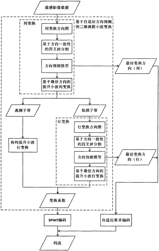
[0044] The technical solutions of the present invention will be clearly and completely described below in combination with the accompanying drawings and specific implementation methods, and specific details of implementation will be introduced. figure 1 The overall flowchart of the program.

[0045] Step 1: Pattern design;

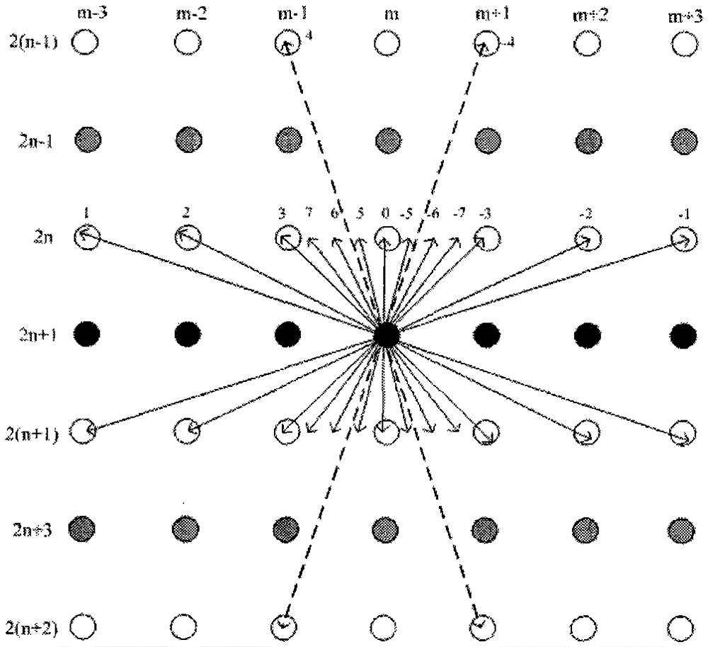
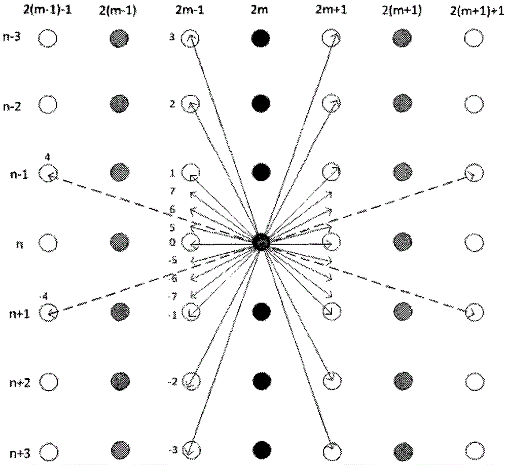
[0046] The direction map designed by the present invention not only covers near-end integer and fractional pixels, but also covers far-end integer pixels, and includes 15 selectable lifting wavelet transform directions in total.

[0047] In the vertical transformation, respectively select the horizontal direction 180°-arctan1, 180°-arctan2, 180°-arctan3, 180°-arctan4, 90°, arctan4, arctan3, arctan2, arctan1, as well as A total of 15 angle directions are used as the alternative directions of the edge or texture of the remote sensing image during vertical transformation, and these directions are marked as 1, 2, 3, 7, 6, 4, 5, 0, -5, -4, -6, -7, -3...


PUM


Abstract

The invention discloses a remote-sensing image compression method for discrete wavelet transform based on self-adaptation direction prediction and belongs to the technical field of remote-sensing image processing. The method comprises the steps that 1) 15 directions which are formed by close-end integer and fraction pixels and far-end integer pixels are considered in a combined mode, a direction graph is established; 2) remote-sensing images are subjected to two-dimensional discrete wavelet transform based on self-adaptation direction prediction, namely quadtree division based on direction consistency is used for dividing the remote-sensing images to a plurality of image blocks which are not overlapped, a new direction prediction model is used for obtaining the best transformation direction of each image block, lifting wavelet transform is completed in the direction; 3) a transformed image coefficient is subjected to SPIHT coding, direction information is subjected to self-adaptation arithmetic coding, and a final code stream is obtained. According to the method, visual quality and peak signal-to-noise ratio of the remote-sensing images are effectively improved, computing complexity of direction wavelet transform is lowered, and the method can be widely used for efficient coding compression of the aviation and satellite remote-sensing images.

Description

technical field [0001] The invention belongs to the technical field of remote sensing image compression, and relates to a remote sensing image compression method based on adaptive direction prediction discrete wavelet transform. Background technique [0002] In recent years, with the rapid development of earth observation technology, the spatial resolution of remote sensing images has been significantly improved, and the amount of remote sensing data has also increased geometrically, which has brought great challenges to data storage and transmission. In the compression technology, the existing technology for natural scene image compression is often used, but the compression effect is very limited. These technologies do not take into account the large amount of high-spatial resolution remote sensing image data, rich texture and edge information, and clear object structure. features. Therefore, it has become a key technology in the development of remote sensing to study the ...

Claims


Application Information

Patent Timeline
Patent Type & Authority Patents(China)
IPC IPC(8): H04N19/63G06T9/00
Inventor 张立保丘兵昌杨凯娜余先川
Owner BEIJING NORMAL UNIVERSITY
Learn More