Method and device for dynamically adding map labels in zoning mode

A dynamic adding and sub-area technology, applied in maps/plans/charts, geographic information databases, special data processing applications, etc., can solve problems such as time-consuming page initialization, poor user experience, and consumption of server-side network bandwidth

Active Publication Date: 2014-01-15
BEIJING TEAMSUN TECH
View PDF5 Cites 2 Cited by
  • Summary
  • Abstract
  • Description
  • Claims
  • Application Information

AI Technical Summary

Problems solved by technology

If such a large amount of data needs to be loaded in one map at one time, the initialization of the page will be very time-consuming and the user experience will be poor
At the same time, it also consumes a lot of network bandwidth on the server side.

Method used


Image

  • Method and device for dynamically adding map labels in zoning mode

Examples


Embodiment Construction

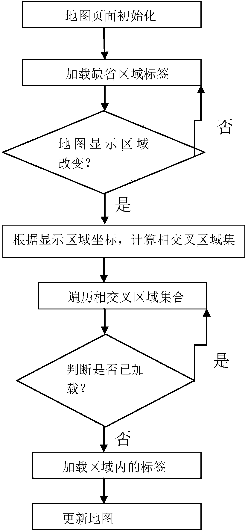
[0033] In order to make the above objects, features and advantages of the present invention more comprehensible, the present invention will be further described in detail below in conjunction with the accompanying drawings and specific embodiments.

[0034] The present invention is used for dynamic loading of label sub-regions, and there are two key technical difficulties:

[0035] 1) How to divide the area;

[0036] 2) How the tags are loaded dynamically.

[0037] Traditional web plane maps are implemented based on the Mercator projection coordinate system: specific to each city, the map of a city can be regarded as a splicing of multiple rectangles, and each rectangle can be regarded as It is a divided area. The rectangular area can be determined as long as there are two coordinate points, one is the coordinates of the upper left corner and the other is the coordinates of the lower right corner.

[0038] How to determine the coordinates of the area? This can be flexibly se...


PUM


Abstract

The invention discloses a method and device for dynamically adding map labels in a zoning mode. The method includes the steps that firstly, a map page is initialized; secondly, labels of a default zone are loaded; thirdly, whether a map display zone is changed or not is judged, if yes, intersection zone sets are calculated by page logic according to coordinates of the display zone; fourthly, the intersection zone sets are traversed, and whether the labels are loaded or not is judged; fifthly, if not, the labels in the zone are loaded; sixthly, a map is updated. According to the method and device for dynamically adding the map labels in the zoning mode, the problem of page loading delay of a large number of label data can be effectively solved, the effect of dynamic loading in the zoning mode according to requirements is achieved, the initialized speed of the page is improved, and the network bandwidth of a server is saved.

Description

technical field [0001] The invention relates to the field of electronic maps, in particular to a method and a device for realizing dynamic addition of map labels in different regions. Background technique [0002] Street view applications in traditional electronic maps generally use two-dimensional maps for navigation and add labels on the map. A label is associated with a point in Street View within a defined area. Labels represent links to Street View locations. The user clicks on the label to realize the linkage between the map and the street view image, thus playing the role of navigation. [0003] Street View applications are generally implemented on a city scale. There are many districts and streets in the city. There must be a scenic spot every 10 meters on the street. In general, a city generally has thousands or even tens of thousands of scenic spots. This is only for medium-sized cities. If it is a large city such as Beijing, Shanghai and Guangzhou, the amount ...

Claims


Application Information

Patent Timeline
Patent Type & Authority Applications(China)
IPC IPC(8): G06F17/30G09B29/00
CPCG06F16/29G06F16/9537G06F16/9574
Inventor 刘兆喜王湛宇邵文韬刘兴辉张志武
Owner BEIJING TEAMSUN TECH
Why Eureka
Try Eureka