A Method of Information Extraction and Hierarchical Cataloging of UAV Reconnaissance Video

A technology of video information and cataloging method, which is applied in the field of unmanned aerial vehicle reconnaissance video information extraction and hierarchical cataloging, which can solve problems such as the combination of unformed systems, improve retrieval efficiency, meet the needs of automation and human-computer interaction, and improve video quality. The effect of retrieval efficiency

Active Publication Date: 2017-02-08
北京北航天宇长鹰无人机科技有限公司
View PDF4 Cites 0 Cited by
  • Summary
  • Abstract
  • Description
  • Claims
  • Application Information

AI Technical Summary

Problems solved by technology

[0005] But so far, the above-mentioned text metadata cataloging and video content-based technology have not yet formed a systematic combination

Method used


Image

  • A Method of Information Extraction and Hierarchical Cataloging of UAV Reconnaissance Video
  • A Method of Information Extraction and Hierarchical Cataloging of UAV Reconnaissance Video
  • A Method of Information Extraction and Hierarchical Cataloging of UAV Reconnaissance Video

Examples


Embodiment Construction

[0021] The specific implementation method of the present invention will be described in detail below in conjunction with the accompanying drawings.

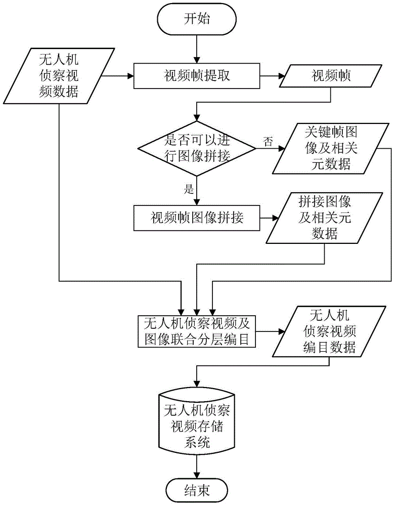
[0022] The overall flow chart of the UAV reconnaissance video information extraction and hierarchical cataloging method of the present invention is as follows figure 1 shown, including the following steps:

[0023] The first step is to extract the key frames of the UAV reconnaissance video and stitch the UAV reconnaissance video.

[0024] This step includes extracting video frames from the UAV reconnaissance video data, and judging whether the extracted video frames can be spliced ​​or are key frames.

[0025] The extracted key frame content mainly includes key transition frames of scene transition and related auxiliary information, and the spliced ​​video mosaic is mainly a panorama that can be spliced ​​after scene transition:

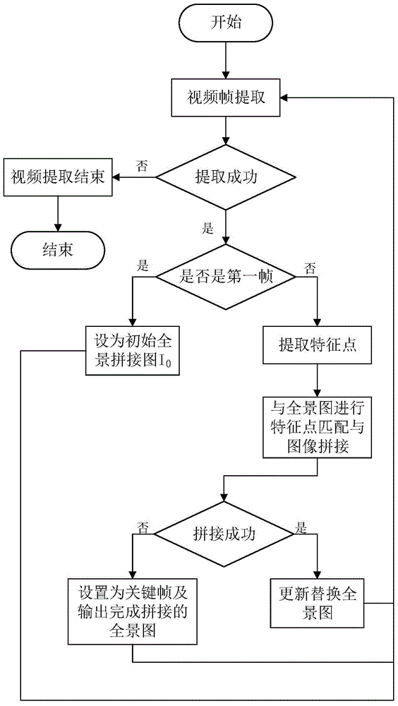
[0026] The first step of the process is as follows figure 2 as shown,

[0027] Step 1.1, extrac...


PUM


Abstract

The invention discloses an unmanned aerial vehicle surveillance video information extracting and layered cataloguing method, and belongs to the technical field of video retrieval. The method comprises the steps that firstly, key frame extraction and video panorama stitching are carried out on unmanned aerial vehicle surveillance video, the main content of the video is extracted, and then layered cataloguing capable of being based on application expansion is carried out according to the extracted image and auxiliary data of the video. The method can be used for unmanned aerial vehicle surveillance video retrieval, and can achieve efficient and comprehensive retrieval based on the video content.

Description

technical field [0001] The invention belongs to the technical field of video retrieval, and in particular relates to a method for extracting and hierarchically cataloging unmanned aerial vehicle reconnaissance video information. Background technique [0002] The existing cataloging standards based on remote sensing image data, the US Federal Geographic Data Committee has formulated a series of US national geospatial data standards, including digital geospatial metadata content standards, remote sensing strip data content standards, digital geospatial metadata content standards Standards - remote sensing metadata extension, etc., the purpose of which is to facilitate data sharing between data producers and data users, so as to support the construction of national spatial data infrastructure. China has also formulated a cataloging and retrieval method for aerospace remote sensing data, including cataloging satellite classification, sensor classification, date classification, c...

Claims


Application Information

Patent Timeline
Patent Type & Authority Patents(China)
IPC IPC(8): G06F17/30
CPCG06F16/739G06F16/7847
Inventor 丁文锐黎盈婷向锦武李红光刘硕
Owner 北京北航天宇长鹰无人机科技有限公司
Why Eureka
Try Eureka