High-resolution remote sensing image scene classifying method based on unsupervised feature learning

A high-resolution, feature learning technology, applied in the field of intelligent analysis of remote sensing images, can solve the problems of high computational cost, failure to mine intrinsic structure and information, and achieve the effect of saving system resources and reducing computational cost

Inactive Publication Date: 2014-07-23
WUHAN UNIV
View PDF3 Cites 25 Cited by
  • Summary
  • Abstract
  • Description
  • Claims
  • Application Information

AI Technical Summary

Problems solved by technology

However, these algorithms directly use the original form of the data as the training data, and do not mine the intrinsic structure and information of the training data in the original data space, making it too computationally expensive in the training and encoding process

Method used


Image

  • High-resolution remote sensing image scene classifying method based on unsupervised feature learning
  • High-resolution remote sensing image scene classifying method based on unsupervised feature learning
  • High-resolution remote sensing image scene classifying method based on unsupervised feature learning

Examples


Embodiment Construction

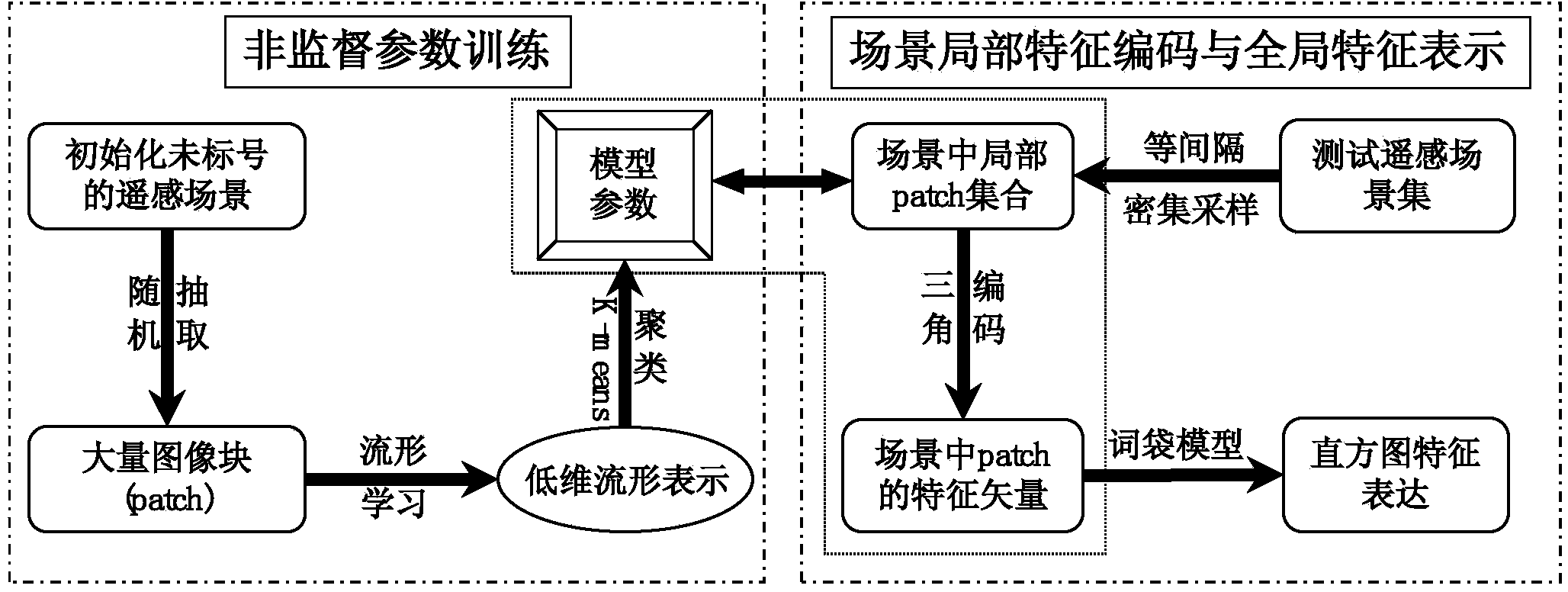
[0043] The technical scheme of the invention can adopt computer software to support the automatic operation process. The technical solution of the present invention will be described in detail below in conjunction with the drawings and embodiments.

[0044] see figure 1 , the embodiment of the present invention includes the following steps:

[0045] Step 1: Scene division of remote sensing images

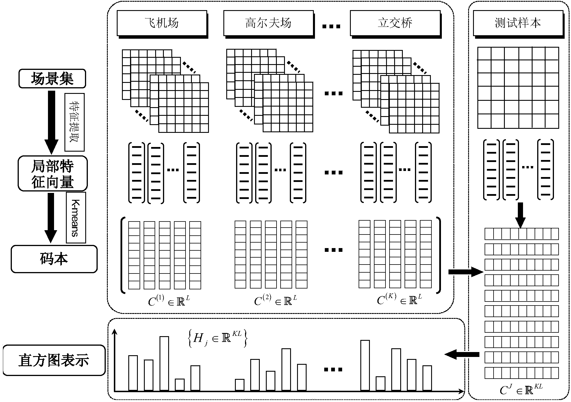
[0046] To classify remote sensing images, the number of scene units and scene categories must first be defined. In the embodiment, a rectangular area of ​​a suitable size is selected as a scene in a large-scale remote sensing image. The ultimate goal is to give all The scene of the scene is assigned a scene category label, and each type of scene is distinguished by a different color. In the specific implementation process, a uniform grid is used to divide the large-scale remote sensing image, and each sub-grid represents a scene, and there is no overlap between adjacent scenes. ...


PUM


Abstract

A high-resolution remote sensing image scene classifying method based on unsupervised feature learning comprises the steps that original input high-resolution remote sensing images are divided to obtain scenes, a plurality of training image blocks are randomly extracted from each scene, and the training image blocks are gathered for conducting preprocessing operation; the low dimension manifold representation of all the training image blocks is calculated, and a set of clustering center is obtained by clustering; intensive sampling is conducted on each scene to obtain local image blocks, each local image block is subjected to preprocessing operation and then is mapped to the same low dimension manifold space, and then encoding is conducted to obtain all local features of the scenes; the local features of all the scenes are gathered to conduct feature quantization, the local feature column diagrams of all the scenes are counted to obtain the global feature representation of the scenes; a plurality of scenes are randomly selected to be used as training samples, the predicted class labels of all the scenes are obtained through a classifier, and thus the labeling task of the original high-resolution remote sensing scenes is achieved.

Description

technical field [0001] The invention belongs to the field of intelligent analysis of remote sensing images, in particular to scene classification for high-resolution remote sensing images, and is a remote sensing scene classification method based on non-supervised feature learning. Background technique [0002] With the rapid development of photogrammetry and remote sensing imaging technology, the number of high-resolution remote sensing images has also increased rapidly, and the demand for remote sensing image interpretation has become more and more urgent. The scene classification of remote sensing images is an important task in the field of intelligent remote sensing information processing, so the rapid understanding and automatic labeling of high-resolution remote sensing image scenes have also received more attention. [0003] A remote sensing scene usually refers to a local area with semantic information in a remote sensing image. For example, a remote sensing image of...

Claims


Application Information

Patent Timeline
Patent Type & Authority Applications(China)
IPC IPC(8): G06K9/62
Inventor 夏桂松胡凡张良培
Owner WUHAN UNIV
Why Eureka
Try Eureka