Geographical-tag-oriented hot spot area event detection system applied to LBSN

A technology of geotag and hotspot area, applied in the field of event detection system for hotspot area based on geotag, can solve the problems of not considering time factor, unable to reflect hotspot area, large area, etc.

Active Publication Date: 2014-08-20
北京中实信息技术有限公司
View PDF3 Cites 14 Cited by
  • Summary
  • Abstract
  • Description
  • Claims
  • Application Information

AI Technical Summary

Problems solved by technology

There are three problems in this method. (1) First, the pre-divided area may divide the actual area into different grids, which cannot reflect the actual hotspot area
(2) The criterion for judging a hotspot area is whether the total number of check-ins in the pre

Method used


Image

  • Geographical-tag-oriented hot spot area event detection system applied to LBSN
  • Geographical-tag-oriented hot spot area event detection system applied to LBSN
  • Geographical-tag-oriented hot spot area event detection system applied to LBSN

Examples


Example Embodiment

[0241] Example

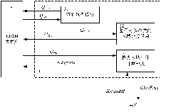
[0242] see figure 1 , figure 2 As shown, assuming that the geo-tagged user check-in information Q is satisfied in the LBSN database 31-2 =R_POI p (x, y), if there are multiple POI search results, apply the clustering interval kcluster-span to perform k-means clustering method to obtain the area block information Q 31-32 ={regX 1 ,regX 2 ,...,regX y}. The Q 31-2 =R_POI p (x, y), POI is just the original record, and has not been clustered yet.

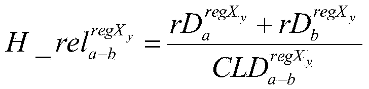
[0243] Hypothesis Q 31-32 ={regX 1 ,regX 2 ,...,regX y} There are 6 coarse-grained geographical regions after clustering, then the number of regional blocks y=6, that is, Q 31-32 ={regX 1 ,regX 2 ,regX 3 ,regX 4 ,regX 5 ,regX 6}.

[0244] in Q 31-32 The distance relationship between the regions is as follows:

[0245]

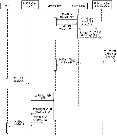
[0246] Assuming that when the user is requested to issue a query request for a local hotspot area, the operation process of the system is as follows:

[0247] Step 1: Request...


PUM


Abstract

The invention discloses a geographical-tag-oriented hot spot area event detection system applied to an LBSN, and belongs to the technical field of network data processing. The detection system is operated in the LBSN and is composed of a sign-in clustering module, an area calculation module based on tag clustering and a hot-spot area event calculation module. The sign-in clustering module is used for performing clustering processing on sign-in information to obtain a geographical area corresponding to the sign-in information, a geographical tag clustering algorithm is adopted by the area calculation module based on tag clustering to obtain an in-cluster area set from the geographical area corresponding to the sign-in information, the sign-in frequency in a time window is applied by the hot spot area event calculation module to obtain a hot spot area event from the in-cluster area set, and therefore the obtained hot spot area event is provided for a user. The cluster is utilized by the geographical-tag-oriented hot spot area event detection system to perform further clustering on points in the cluster within the smaller range, and the system has the advantages of being capable of greatly reducing the calculated data volume in the LBSN and improving the calculation efficiency.

Description

technical field [0001] The present invention relates to the technical field of geotag check-in, more particularly, refers to a geotag-based event detection system for hotspot areas applied to LBSN networks, wherein the hotspots are clustered based on tags and geographic locations divided. Background technique [0002] Geographic tags (Geo Tags) refer to data information used to describe the geographical location of a point of interest, and its information content includes address information of the point of interest, longitude and latitude information of the point of interest. Geographical tags can better digitize the geographic location information of points of interest, which is conducive to global data positioning and geographic location information traceability. Geotags are also known as geo-identifications. Check-in records refer to the data information obtained by social subjects signing in at points of interest. [0003] Currently, location-based social networking ...

Claims


Application Information

Patent Timeline
IPC IPC(8): G06F17/30H04W4/02
CPCG06F16/9537H04W4/02
Inventor 李巍李国君李云春蒋江涛
Owner 北京中实信息技术有限公司
Why Eureka
Try Eureka